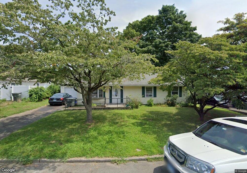
148 Corn Tassel Rd Bridgeport, CT 06606
North End NeighborhoodEstimated Value: $343,000 - $415,000
3
Beds
1
Bath
1,100
Sq Ft
$353/Sq Ft
Est. Value
About This Home
This home is located at 148 Corn Tassel Rd, Bridgeport, CT 06606 and is currently estimated at $388,796, approximately $353 per square foot. 148 Corn Tassel Rd is a home located in Fairfield County with nearby schools including John Winthrop School, Central High School, and St Andrew School.
Ownership History
Date
Name
Owned For
Owner Type
Purchase Details
Closed on
Aug 9, 1993
Sold by
Pulley Anna and Pekar Adaline
Bought by
Delponte Fausto
Current Estimated Value
Create a Home Valuation Report for This Property
The Home Valuation Report is an in-depth analysis detailing your home's value as well as a comparison with similar homes in the area
Home Values in the Area
Average Home Value in this Area
Purchase History
| Date | Buyer | Sale Price | Title Company |
|---|---|---|---|
| Delponte Fausto | $80,000 | -- | |
| Delponte Fausto | $80,000 | -- |
Source: Public Records
Mortgage History
| Date | Status | Borrower | Loan Amount |
|---|---|---|---|
| Open | Delponte Fausto | $185,000 | |
| Closed | Delponte Fausto | $103,946 | |
| Closed | Delponte Fausto | $15,000 | |
| Closed | Delponte Fausto | $70,551 |
Source: Public Records
Tax History Compared to Growth
Tax History
| Year | Tax Paid | Tax Assessment Tax Assessment Total Assessment is a certain percentage of the fair market value that is determined by local assessors to be the total taxable value of land and additions on the property. | Land | Improvement |
|---|---|---|---|---|
| 2025 | $6,352 | $146,200 | $77,800 | $68,400 |
| 2024 | $6,352 | $146,200 | $77,800 | $68,400 |
| 2023 | $6,352 | $146,200 | $77,800 | $68,400 |
| 2022 | $6,352 | $146,200 | $77,800 | $68,400 |
| 2021 | $6,352 | $146,200 | $77,800 | $68,400 |
| 2020 | $6,280 | $116,320 | $60,960 | $55,360 |
| 2019 | $6,280 | $116,320 | $60,960 | $55,360 |
| 2018 | $6,324 | $116,320 | $60,960 | $55,360 |
| 2017 | $6,324 | $116,320 | $60,960 | $55,360 |
| 2016 | $6,324 | $116,320 | $60,960 | $55,360 |
| 2015 | $5,285 | $125,230 | $60,020 | $65,210 |
| 2014 | $5,285 | $125,230 | $60,020 | $65,210 |
Source: Public Records
Map
Nearby Homes
- 64 Dobson St
- 65 Dobson St
- 50 Greenhouse Rd Unit 65D
- 50 Greenhouse Rd Unit 42C
- 173 Anton Dr
- 394 Anton Dr
- 236 Edgemoor Rd Unit D
- 9 Patricia Rd Unit C
- 2851 Old Town Rd
- 2998 Madison Ave Unit C
- 87 Oliver St
- 153 Seaver Cir
- 72 Herald Ave
- 15 Cherry Hill Dr Unit 2A
- 230 Cherry Hill Dr Unit 2B
- 2800 Madison Ave Unit 1B
- 265 Vincellette St
- 114 Oxford St
- 2955 Madison Ave Unit 40
- 344 Cambridge St
- 132 Corn Tassel Rd
- 193 Indian Field Rd
- 145 Corn Tassel Rd
- 131 Corn Tassel Rd
- 175 Sunburst Rd
- 161 Sunburst Rd
- 116 Corn Tassel Rd
- 157 Corn Tassel Rd
- 181 Indian Field Rd
- 145 Sunburst Rd
- 184 Sunburst Rd
- 94 Corn Tassel Rd
- 111 Corn Tassel Rd
- 196 Indian Field Rd
- 241 Indian Field Rd
- 170 Sunburst Rd
- 278 Bear Paw Rd
- 150 Sunburst Rd
- 130 Sunburst Rd