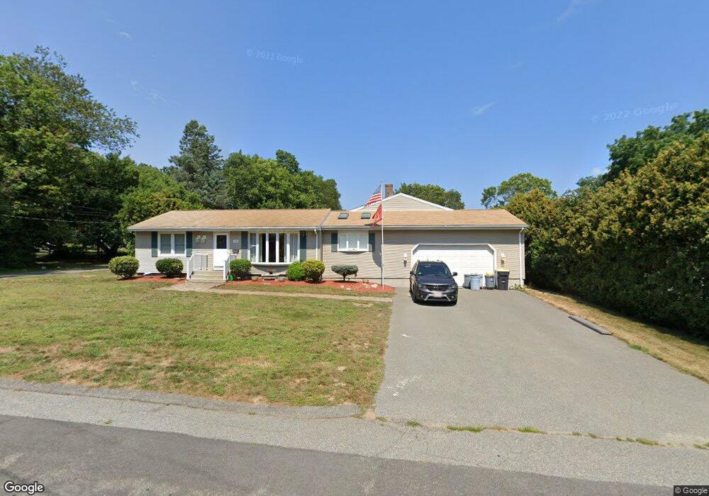
148 Grove Ave Somerset, MA 02726
Pottersville NeighborhoodEstimated Value: $541,481 - $645,000
About This Home
This home is located at 148 Grove Ave, Somerset, MA 02726 and is currently estimated at $597,120, approximately $297 per square foot. 148 Grove Ave is a home located in Bristol County with nearby schools including North Elementary School, Somerset Middle School, and St. Michael's School.
Ownership History
We collect this data history from publicly available records. To have your information removed, we recommend requesting removal directly through your county’s website.
Purchase Details
Home Values in the Area
Average Home Value in this Area
Purchase History
We collect this data history from publicly available records. To have your information removed, we recommend requesting removal directly through your county’s website.
| Date | Buyer | Sale Price | Title Company |
|---|---|---|---|
| $126,500 | -- | ||
| $126,500 | -- |
Mortgage History
We collect this data history from publicly available records. To have your information removed, we recommend requesting removal directly through your county’s website.
| Date | Status | Borrower | Loan Amount |
|---|---|---|---|
| Open | $188,000 | ||
| Closed | $195,000 |
Tax History
We collect this data history from publicly available records. To have your information removed, we recommend requesting removal directly through your county’s website.
| Year | Tax Paid | Tax Assessment Tax Assessment Total Assessment is a certain percentage of the fair market value that is determined by local assessors to be the total taxable value of land and additions on the property. | Land | Improvement |
|---|---|---|---|---|
| 2025 | $6,554 | $492,800 | $184,300 | $308,500 |
| 2024 | $6,157 | $481,400 | $184,300 | $297,100 |
| 2023 | $5,423 | $427,700 | $160,200 | $267,500 |
| 2022 | $5,040 | $379,200 | $138,800 | $240,400 |
| 2021 | $5,103 | $347,600 | $125,800 | $221,800 |
| 2020 | $5,185 | $340,700 | $127,000 | $213,700 |
| 2019 | $5,836 | $319,800 | $127,000 | $192,800 |
| 2018 | $5,091 | $300,200 | $123,400 | $176,800 |
| 2017 | $4,969 | $285,600 | $117,700 | $167,900 |
| 2016 | $5,001 | $285,600 | $117,700 | $167,900 |
| 2015 | $4,731 | $272,700 | $115,800 | $156,900 |
| 2014 | $6,540 | $270,800 | $115,800 | $155,000 |
Map
- 194 Grove Ave
- 126 Grove Ave
- 92 Everett St
- 2714 Riverside Ave
- 8 Deer St
- 372 Buffinton St
- 30 Gray St
- 46 Lilac Ave
- 4234 N Main St Unit 208
- 26 Robin Ln
- 146 Colonial Dr
- 50 Clark St Unit 22
- 205 Eastview Ave
- 120 Millard St
- 74 South St
- 244 Connecticut Ave
- 503 Bark St
- 79 Highview Ave
- 4700 N Main St Unit 1
- 175 High St
- 177 Grove Ave
- 147 Grove Ave
- 199 Grove Ave
- 174 Grove Ave
- 171 Seymour Ave
- 226 Grove Ave
- 121 Grove Ave
- 49 Winter St
- 147 Seymour Ave
- 1592 County St
- 1592 County St Unit 1
- 36 Winter St
- 118 Seymour Ave
- 1570 County St
- 133 Seymour Ave
- 1576 County St
- 188 Centre St
- 188 Centre St Unit 2
- 188 Centre St Unit 1
- 52 Winter St
Ask me questions while you tour the home.