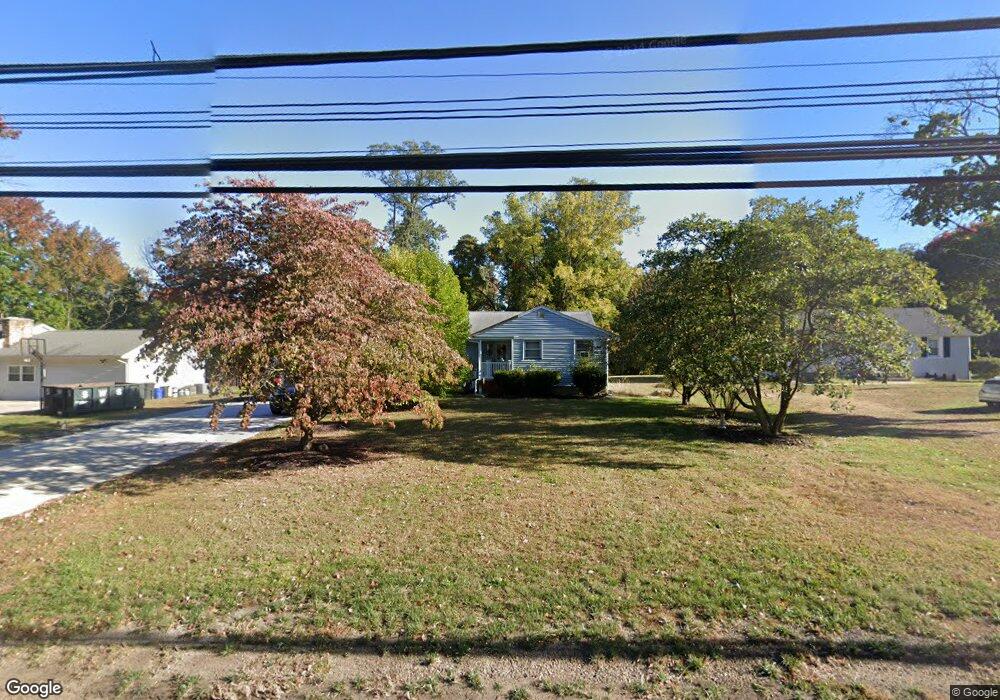
148 Millhurst Rd Manalapan, NJ 07726
Estimated Value: $429,000 - $563,000
3
Beds
1
Bath
1,310
Sq Ft
$368/Sq Ft
Est. Value
About This Home
This home is located at 148 Millhurst Rd, Manalapan, NJ 07726 and is currently estimated at $482,000, approximately $367 per square foot. 148 Millhurst Rd is a home located in Monmouth County with nearby schools including Wemrock Brook School, Manalapan-Englishtown Middle School, and Pine Brook Elementary School.
Ownership History
Date
Name
Owned For
Owner Type
Purchase Details
Closed on
Mar 23, 2017
Sold by
Ham Alma L and Ham Michael Ham
Bought by
Ham Heritage Llc
Current Estimated Value
Home Financials for this Owner
Home Financials are based on the most recent Mortgage that was taken out on this home.
Interest Rate
4.23%
Create a Home Valuation Report for This Property
The Home Valuation Report is an in-depth analysis detailing your home's value as well as a comparison with similar homes in the area
Home Values in the Area
Average Home Value in this Area
Purchase History
| Date | Buyer | Sale Price | Title Company |
|---|---|---|---|
| Ham Heritage Llc | -- | -- |
Source: Public Records
Mortgage History
| Date | Status | Borrower | Loan Amount |
|---|---|---|---|
| Closed | Ham Heritage Llc | -- |
Source: Public Records
Tax History Compared to Growth
Tax History
| Year | Tax Paid | Tax Assessment Tax Assessment Total Assessment is a certain percentage of the fair market value that is determined by local assessors to be the total taxable value of land and additions on the property. | Land | Improvement |
|---|---|---|---|---|
| 2025 | $4,946 | $320,300 | $169,500 | $150,800 |
| 2024 | $4,824 | $293,000 | $169,500 | $123,500 |
| 2023 | $4,824 | $290,100 | $169,500 | $120,600 |
| 2022 | $4,884 | $280,500 | $165,700 | $114,800 |
| 2021 | $4,884 | $234,600 | $132,500 | $102,100 |
| 2020 | $4,822 | $234,100 | $132,500 | $101,600 |
| 2019 | $4,780 | $231,700 | $132,500 | $99,200 |
| 2018 | $4,787 | $230,600 | $145,800 | $84,800 |
| 2017 | $4,733 | $228,100 | $145,800 | $82,300 |
| 2016 | $4,956 | $241,300 | $150,500 | $90,800 |
| 2015 | $4,924 | $237,200 | $148,800 | $88,400 |
| 2014 | $4,430 | $208,000 | $94,500 | $113,500 |
Source: Public Records
Map
Nearby Homes
- 132 Millhurst Rd
- 11 Weamaconk Dr
- 33 Tennent Ave
- 9 Tennent Ave
- 17 Tennent Ave
- 21 Harrison Ave
- 45 McCaffery Rd
- 136 Iron Ore Rd
- 53 McCaffery Rd
- 10 Milton Ave
- 1213 Auburn Terrace Unit 1203
- 1212 Auburn Terrace Unit 1202
- 1214 Auburn Terrace Unit 1204
- 1213 Auburn Terrace
- 1212 Auburn Terrace
- 2013 Wander Ln Unit 2003
- 2014 Wander Ln Unit 2004
- 2011 Wander Ln Unit 2001
- 2013 Wander Ln
- 148 McCaffery Rd
- 150 Millhurst Rd
- 146 Millhurst Rd
- 144 Millhurst Rd
- 29 Station St
- 27 Station St
- 142 Millhurst Rd
- 2 Millhurst Rd
- 25 Station St
- 138 Millhurst Rd
- 136 Millhurst Rd
- 134 Millhurst Rd
- 24 Station St
- 167 Millhurst Rd
- 600 Gold Ct
- 22 Station St
- 21 Conover St
- 171 Millhurst Rd
- 20 Station St
- 18 Station St
- 19 Conover St