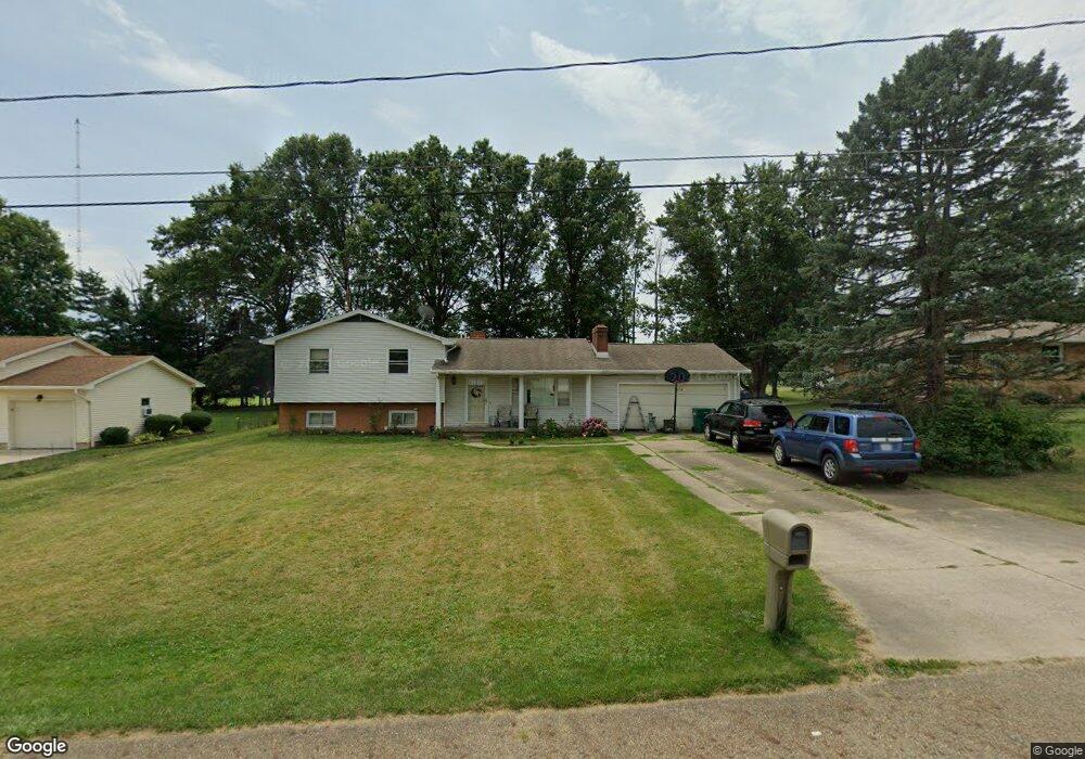
1484 Mishler Ave Alliance, OH 44601
Estimated Value: $197,000 - $252,000
3
Beds
2
Baths
1,480
Sq Ft
$151/Sq Ft
Est. Value
About This Home
This home is located at 1484 Mishler Ave, Alliance, OH 44601 and is currently estimated at $224,168, approximately $151 per square foot. 1484 Mishler Ave is a home located in Stark County with nearby schools including Marlington High School and Regina Coeli/St Joseph School.
Ownership History
Date
Name
Owned For
Owner Type
Purchase Details
Closed on
Aug 26, 2016
Bought by
Julie A Cain
Current Estimated Value
Home Financials for this Owner
Home Financials are based on the most recent Mortgage that was taken out on this home.
Interest Rate
3.43%
Purchase Details
Closed on
Nov 25, 2008
Sold by
Marshall Ralph A
Bought by
Marshall Ralph A
Create a Home Valuation Report for This Property
The Home Valuation Report is an in-depth analysis detailing your home's value as well as a comparison with similar homes in the area
Purchase History
| Date | Buyer | Sale Price | Title Company |
|---|---|---|---|
| Julie A Cain | -- | -- | |
| Marshall Ralph A | -- | Attorney |
Source: Public Records
Mortgage History
| Date | Status | Borrower | Loan Amount |
|---|---|---|---|
| Closed | Julie A Cain | -- |
Source: Public Records
Tax History
| Year | Tax Paid | Tax Assessment Tax Assessment Total Assessment is a certain percentage of the fair market value that is determined by local assessors to be the total taxable value of land and additions on the property. | Land | Improvement |
|---|---|---|---|---|
| 2025 | -- | $71,790 | $22,090 | $49,700 |
| 2024 | -- | $71,790 | $22,090 | $49,700 |
| 2023 | $1,821 | $51,700 | $15,580 | $36,120 |
| 2022 | $1,827 | $51,700 | $15,580 | $36,120 |
| 2021 | $1,833 | $51,700 | $15,580 | $36,120 |
| 2020 | $1,808 | $45,440 | $13,410 | $32,030 |
| 2019 | $1,796 | $45,440 | $13,410 | $32,030 |
Source: Public Records
Map
Nearby Homes
- 550 Johnson Ave
- 347 Buckeye Ave
- 432 Johnson Ave
- 000 Meadowbrook Ave
- 0 W Main St Unit 5090123
- 0 Meadowbrook Ave
- 160 Bonnieview Ave
- 11335 Meadowbrook Ave NE
- 10580 Heltman Ave NE
- 0 Homestead Ave NE
- 0 Meadow St NE
- 664 Fairview Place
- 479 W High St
- 118 S Mckinley Ave
- 717 Garfield Ave
- 264 W Market St
- 535 S Mckinley Ave
- 171 1/2 W Main St
- 163 W Market St
- 1044 Glamorgan St
- 1488 Mishler St NE
- 1496 Mishler Ave
- 1485 Mishler Ave
- 1489 Mishler Ave
- 1489 Mishler St NE
- 537 Smyth Ave
- 1451 Mishler Ave
- 1470 Mishler St NE
- 459 Smyth Ave
- 1471 Mishler St NE
- 520 Smyth Ave
- 540 Smyth Ave
- 1488 Lambert St
- 600 Smyth Ave
- 1484 Lambert St
- 452 Smyth Ave
- 1451 Mishler St NE
- 630 Smyth Ave
- 442 Smyth Ave
- 1470 Lambert St
Your Personal Tour Guide
Ask me questions while you tour the home.