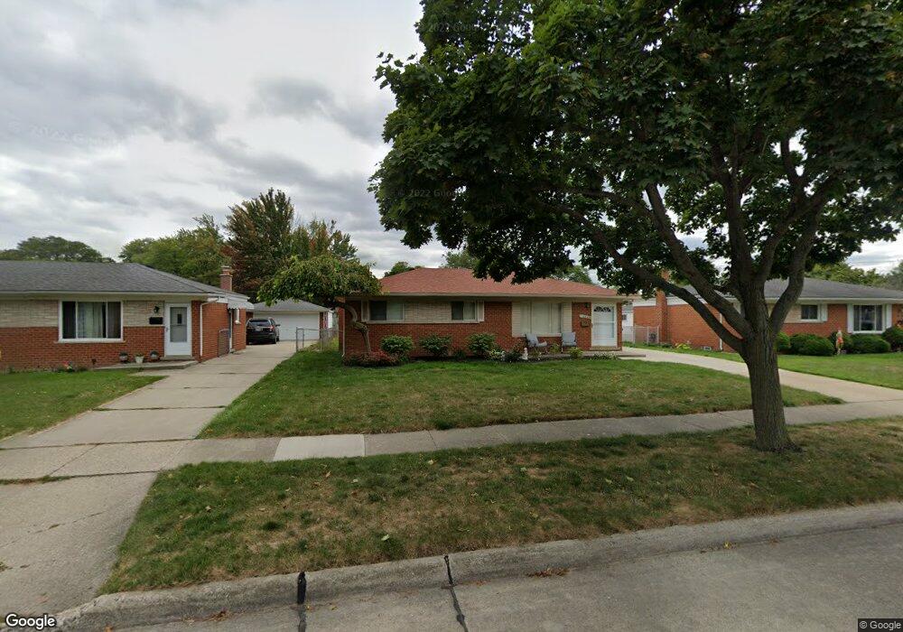
14840 Colpaert Dr Warren, MI 48088
Northeast Warren NeighborhoodEstimated Value: $204,649 - $280,000
--
Bed
2
Baths
1,183
Sq Ft
$207/Sq Ft
Est. Value
About This Home
This home is located at 14840 Colpaert Dr, Warren, MI 48088 and is currently estimated at $245,162, approximately $207 per square foot. 14840 Colpaert Dr is a home located in Macomb County with nearby schools including Wilde Elementary School, Carter Middle School, and Paul K. Cousino High School.
Ownership History
Date
Name
Owned For
Owner Type
Purchase Details
Closed on
Mar 24, 2018
Sold by
Lince Donna and Dezern Grace
Bought by
Murphy Frances and Mordell Ronald
Current Estimated Value
Home Financials for this Owner
Home Financials are based on the most recent Mortgage that was taken out on this home.
Original Mortgage
$93,500
Outstanding Balance
$67,672
Interest Rate
4.45%
Mortgage Type
New Conventional
Estimated Equity
$177,490
Purchase Details
Closed on
Mar 8, 2005
Sold by
Murphy Frances and Mordell Frances
Bought by
Murphy Frances and Lince Donna
Create a Home Valuation Report for This Property
The Home Valuation Report is an in-depth analysis detailing your home's value as well as a comparison with similar homes in the area
Home Values in the Area
Average Home Value in this Area
Purchase History
| Date | Buyer | Sale Price | Title Company |
|---|---|---|---|
| Murphy Frances | -- | None Available | |
| Murphy Frances | -- | -- |
Source: Public Records
Mortgage History
| Date | Status | Borrower | Loan Amount |
|---|---|---|---|
| Open | Murphy Frances | $93,500 |
Source: Public Records
Tax History Compared to Growth
Tax History
| Year | Tax Paid | Tax Assessment Tax Assessment Total Assessment is a certain percentage of the fair market value that is determined by local assessors to be the total taxable value of land and additions on the property. | Land | Improvement |
|---|---|---|---|---|
| 2025 | $2,683 | $102,510 | $0 | $0 |
| 2024 | $2,607 | $94,240 | $0 | $0 |
| 2023 | $2,471 | $85,600 | $0 | $0 |
| 2022 | $2,388 | $74,480 | $0 | $0 |
| 2021 | $2,430 | $70,490 | $0 | $0 |
| 2020 | $2,343 | $68,440 | $0 | $0 |
| 2019 | $2,259 | $64,200 | $0 | $0 |
| 2018 | $2,295 | $59,240 | $0 | $0 |
| 2017 | $2,265 | $54,410 | $9,830 | $44,580 |
| 2016 | $2,263 | $54,410 | $0 | $0 |
| 2015 | -- | $48,020 | $0 | $0 |
| 2012 | -- | $39,320 | $0 | $0 |
Source: Public Records
Map
Nearby Homes
- 14717 Colpaert Dr
- 14646 Murthum Ave
- 31707 Gloede Dr
- 32334 Gloede Dr
- 31341 Hayes Rd
- 32717 Beechwood Dr
- 31263 Hayes Rd
- 15621 Lauren
- 14514 Peck Dr
- 31070 Hayes Rd
- 15668 Masonic
- 13842 Jenny Dr
- 13863 Colpaert Dr
- 13738 Jenny Dr
- 33333 Groth Dr
- 30644 Hayes Rd
- 15801 Toulouse Unit 6
- 15958 Kingston Dr
- 33125 Mazara
- 33042 Mccoy Dr
- 14852 Colpaert Dr
- 14828 Colpaert Dr
- 14864 Colpaert Dr
- 14873 Masonic Blvd
- 14885 Masonic Blvd
- 14861 Masonic Blvd Unit Bldg-Unit
- 14861 Masonic Blvd
- 32048 Gloede Dr
- 32036 Gloede Dr
- 14907 Masonic Blvd
- 32024 Gloede Dr
- 14906 Colpaert Dr
- 14839 Colpaert Dr
- 14851 Colpaert Dr
- 14827 Colpaert Dr
- 14863 Colpaert Dr
- 32012 Gloede Dr
- 14815 Colpaert Dr
- 14918 Colpaert Dr
- 14905 Colpaert Dr