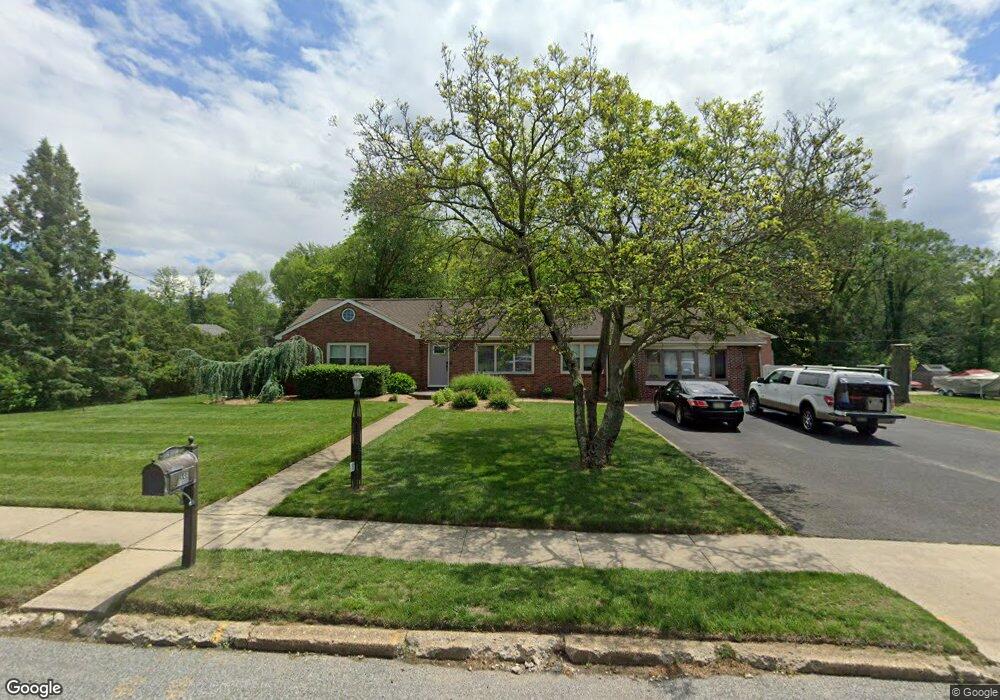
1485 Crown Point Rd West Deptford, NJ 08093
West Deptford Township NeighborhoodEstimated Value: $402,280 - $479,000
--
Bed
--
Bath
2,340
Sq Ft
$186/Sq Ft
Est. Value
About This Home
This home is located at 1485 Crown Point Rd, West Deptford, NJ 08093 and is currently estimated at $435,320, approximately $186 per square foot. 1485 Crown Point Rd is a home located in Gloucester County with nearby schools including Oakview Elementary School, Red Bank Elementary School, and Green-Fields Elementary School.
Ownership History
Date
Name
Owned For
Owner Type
Purchase Details
Closed on
Sep 15, 2014
Sold by
Hesser Jeffrey M and Hesser Sabrina W
Bought by
Hesser Jeffrey M and Hesser Sabrina W
Current Estimated Value
Home Financials for this Owner
Home Financials are based on the most recent Mortgage that was taken out on this home.
Original Mortgage
$132,500
Outstanding Balance
$41,833
Interest Rate
3.24%
Mortgage Type
New Conventional
Estimated Equity
$393,487
Purchase Details
Closed on
Mar 26, 2004
Sold by
Mikulski Christopher and Mikulski Noreen
Bought by
Hesser Jeffery M and Walker Sabrina
Home Financials for this Owner
Home Financials are based on the most recent Mortgage that was taken out on this home.
Original Mortgage
$175,000
Interest Rate
5.88%
Mortgage Type
Purchase Money Mortgage
Purchase Details
Closed on
Oct 29, 1999
Sold by
Mikulski John N and Mikulski Patricia M
Bought by
Mikulski Christopher and Mikulski Noreen
Create a Home Valuation Report for This Property
The Home Valuation Report is an in-depth analysis detailing your home's value as well as a comparison with similar homes in the area
Home Values in the Area
Average Home Value in this Area
Purchase History
| Date | Buyer | Sale Price | Title Company |
|---|---|---|---|
| Hesser Jeffrey M | -- | Attorney | |
| Hesser Jeffery M | $225,400 | -- | |
| Mikulski Christopher | $75,000 | -- |
Source: Public Records
Mortgage History
| Date | Status | Borrower | Loan Amount |
|---|---|---|---|
| Open | Hesser Jeffrey M | $132,500 | |
| Previous Owner | Hesser Jeffery M | $175,000 |
Source: Public Records
Tax History Compared to Growth
Tax History
| Year | Tax Paid | Tax Assessment Tax Assessment Total Assessment is a certain percentage of the fair market value that is determined by local assessors to be the total taxable value of land and additions on the property. | Land | Improvement |
|---|---|---|---|---|
| 2025 | $9,603 | $275,000 | $75,000 | $200,000 |
| 2024 | $9,479 | $275,000 | $75,000 | $200,000 |
| 2023 | $9,479 | $275,000 | $75,000 | $200,000 |
| 2022 | $9,435 | $275,000 | $75,000 | $200,000 |
| 2021 | $9,402 | $275,000 | $75,000 | $200,000 |
| 2020 | $9,380 | $275,000 | $75,000 | $200,000 |
| 2019 | $9,119 | $275,000 | $75,000 | $200,000 |
| 2018 | $8,872 | $275,000 | $75,000 | $200,000 |
| 2017 | $8,665 | $275,000 | $75,000 | $200,000 |
| 2016 | $8,423 | $275,000 | $75,000 | $200,000 |
| 2015 | $8,025 | $275,000 | $75,000 | $200,000 |
| 2014 | $7,626 | $275,000 | $75,000 | $200,000 |
Source: Public Records
Map
Nearby Homes
- 1009 Hessian Ave
- 1448 Victory Ave
- 1372 Riley Ave
- 1156 Hessian Ave
- 1346 Verga Ave
- 321 May Ave
- 1174 Harker Ave
- 210 Lawnton Ave
- 541 Elberne Ave
- 1676 Miller Ave
- 193 Dubois Ave
- 2 Victorian Way
- 3 Victorian Way
- 7 Victorian Way
- 120 Progress Ave
- 131 Watkins Ave
- 121 Crescent Ave
- 1029 Tatum St
- 654 Frances Ave
- 66 Hessian Ave
- 1491 Crown Point Rd
- 1482 Crown Point Rd
- 1465 Crown Point Rd
- 1492 Crown Point Rd
- 1476 Crown Point Rd
- 1470 Crown Point Rd
- 1424 Woodlane Dr
- 1498 Crown Point Rd
- 1422 Woodlane Dr
- 1458 Crown Point Rd
- 1420 Woodlane Dr
- 1504 Crown Point Rd
- 1454 Crown Point Rd
- 1411 Woodlane Dr
- 37 Birchly Ct
- 1418 Woodlane Dr
- 1450 Crown Point Rd
- 1409 Woodlane Dr
- 1516 Crown Point Rd
- 1446 Crown Point Rd