NOT LISTED FOR SALE

14867 Malico Mountain Rd West Fork, AR 72774

Estimated Value: $203,511 - $253,000

15 Acres
$15,243 Price per Acre
659,063 Sq Ft Lot

Last Sold June 20, 2023

Last sale price $235,000

Est. 2% decrease in value since last sale

Current estimated payment $1,306/month

24 Days on Market

Highlights

  • Partially Wooded Lot
  • Creek or Stream
  • Open Lot

About This Lot

As of June 2023

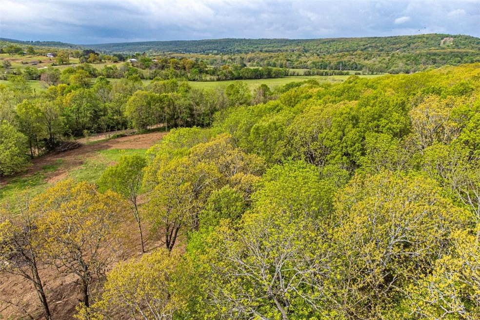
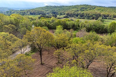
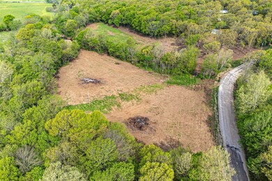
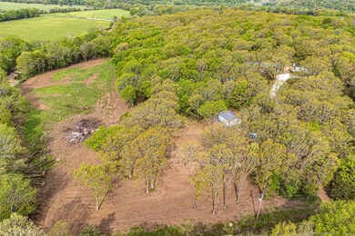
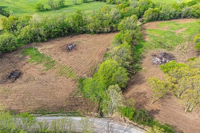
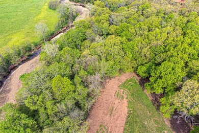
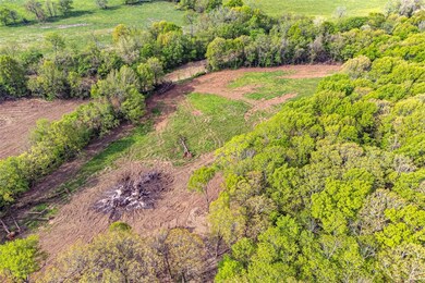
OPPORTUNITY GALORE! This 15.13 acres +/- is partially cleared and partially wooded on a gentle slope with a GORGEOUS CREEK on the property perfect for enjoying the upcoming summer months! Whether your looking for something recreational, a place for a shop, or to build your dream home and small hobby farm this is just what you have been waiting for! Property has electric on-site and well water, and rural water on site! Property also includes a garage/shop building perfect for additional storage or to work from while you work on projects! Located 10 minutes away from 1-49 and downtown West Fork and 15 minutes from Devils Den State Park! This opportunity won't last for long! Act now!

Last Agent to Sell the Property

Terri McNaughton

McNaughton Real Estate License #PB00001140 Listed on: 04/20/2023

Last Buyer's Agent

Hunt Homes Homes

Roots Real Estate Group

Property Details

Property Type

  • Land

Est. Annual Taxes

  • $449

Lot Details

  • 15.13 Acre Lot
  • Property fronts a county road
  • Creek or Stream
  • Rural Setting
  • Open Lot
  • Sloped Lot
  • Partially Wooded Lot

Home Design

  • Mixed Use

Location

  • Outside City Limits

Utilities

  • Water Tap Fee Is Paid
  • Well
  • Septic Needed

Community Details

  • Donnybrook Farms Subdivision

Listing and Financial Details

  • Tax Lot 3

Property Details

Property Type

Land

Est. Annual Taxes

$449

Lot Details

0

Listing Details

  • Property Sub Type: Mixed Use
  • Prop. Type: Land
  • Lot Size Acres: 15.13
  • Road Frontage Type: County Road, Public Road
  • Road Surface Type: Paved
  • Subdivision Name: Donnybrook Farms
  • Directions: Heading south on I-49, exit 53, right at the fork, Turn right onto AR-156 W (4.2 mi), left to stay on AR-265 S (1.5 mi), Slight left onto Malico Mountain Rd, in 0.4 miles, property will be on the left
  • ResoPropertyType: Land
  • Property Sub Type Additional: Mixed Use
  • Special Features: VirtualTour

Exterior Features

  • Fencing: None
  • Lot Features: None, Outside City Limits, Open Lot, Rural Lot, Wooded, Stream/Creek
  • Topography: Sloping

Utilities

  • Electricity On Property: Yes
  • Sewer: Septic Needed
  • Utilities: Electricity Available
  • Water Source: Rural, Well, Water Tap Paid

Schools

  • Junior High Dist: West Fork

Lot Info

  • Zoning: N
  • ResoLotSizeUnits: Acres

Tax Info

  • Tax Annual Amount: 449.0
  • Tax Block: 0
  • Tax Lot: 3

Ownership History

Date Name Owned For Owner Type

Purchase Details

Closed on
Jul 25, 1990
Bought by
Springer Charles and Springer Jeanine J
Current Estimated Value
$230,628

Purchase Details

Closed on
Jan 1, 1985
Bought by
Boyd Gerald Lee and Boyd Catherine C

Purchase Details

Closed on
Mar 1, 1983
Bought by
Scogin David H and Scogin Bobbi R
Source: Public Records

Similar Property in West Fork, AR

  • 13.32 acres Delgado Rd, West Fork, AR 72774

    $270,000

    • Land
    • 13 Acres
    • $20,270 per Acre
    • 13.32 acres Delgado Rd
    • West Fork, AR

    15 miles south of the University of Arkansas, 13+/- acres with incredible mountain top views! You can enjoy nature, peace and privacy in the Boston Mountains without sacrificing reasonable commute times. Multiple building sites w/soil test, notable outcroppings, beautiful native stone, and abundant wildlife. 19 miles to Devil's Den State Park. 17 miles to Lake Fork Smith State Park. Only 2 miles

    Angela Thompson Fathom Realty

    Section Image

Range of Values:

Collateral Analytics

Collateral Analytics Collateral Analytics AVMs (Automated Valuation Model) employ a number of statistical approaches combined with neighborhood-specific comparable selection guarantees the most up-to-date and precise valuations.

Not Available

Collateral Analytics does not have data for the current month. Please view the chart for historical values.

ICE

ICE Mortgage Technology ICE Mortgage Technology’s AVM (Automated Valuation Model) is a state-of-the-art online residential property valuation tool that provides a quick and accurate estimate of the value of almost any home in the U.S.

Not Available

ICE Mortgage Technology does not have data for the current month. Please view the chart for historical values.

First American

First American First American Data & Analytics’ next-generation AVM combines unrivaled data assets with a blended ensemble of valuation models to produce highly accurate, reliable valuations you can trust.

Not Available

First American does not have data for the current month. Please view the chart for historical values.

Quantarium

Quantarium Quantarium’s valuation service, repeatedly proven the industry’s most accurate and comprehensive, is supercharged with a self-learning and auto-tuning AI engine that continually becomes smarter and more accurate as it processes daily inputs from the industry’s leading RE data lake.

Not Available

Quantarium does not have data for the current month. Please view the chart for historical values.

Average Value
Not Available
List Price
Sold Price
Create a Home Valuation Report for This Property
The Home Valuation Report is an in-depth analysis detailing your home's value as well as a comparison with similar homes in the area

Home Values in the Area

Source: Public Records

Average Home Value in this Area


Source: Public Records

Purchase History

Date Buyer Sale Price Title Company
Springer Charles $26,000 --
Boyd Gerald Lee -- --
Scogin David H $32,000 --
Source: Public Records

Property History

Date Event Price Change Sq Ft Price
06/20/2023 06/20/23 Sold $235,000 -4.1% --
05/15/2023 05/15/23 Pending -- -- --
04/20/2023 04/20/23 For Sale $245,000 +28.9% --
08/30/2022 08/30/22 Sold $190,000 -3.3% --
08/17/2022 08/17/22 Pending -- -- --
08/10/2022 08/10/22 For Sale $196,500 -- --
Source: Northwest Arkansas Board of REALTORS®

Tax History Compared to Growth

Source: Public Records

Tax History

Year Tax Paid Tax Assessment Tax Assessment Total Assessment is a certain percentage of the fair market value that is determined by local assessors to be the total taxable value of land and additions on the property. Land Improvement
2024 $450 $9,400 $9,400 $0
2023 $452 $9,400 $9,400 $0
2022 $141 $2,890 $2,890 $0
2021 $449 $8,820 $2,890 $5,930
2020 $416 $8,820 $2,890 $5,930
2019 $383 $6,890 $2,410 $4,480
2018 $383 $6,890 $2,410 $4,480
2017 $321 $6,890 $2,410 $4,480
2016 $373 $6,890 $2,410 $4,480
2015 $373 $6,890 $2,410 $4,480
2014 $351 $6,420 $2,200 $4,220
Source: Public Records

Agents Affiliated with this Home

  • Section Image
  • Section Image
  • Section Image
See All Agents

Map

Source: Northwest Arkansas Board of REALTORS®

MLS Number: 1244023

Northwest Arkansas Board of REALTORS®

APN: 168-00812-000