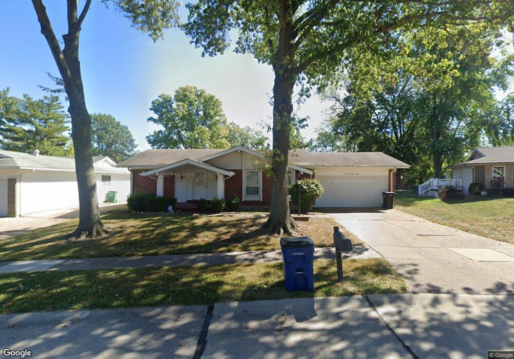
1489 Matlock Dr Florissant, MO 63031
Estimated Value: $196,000 - $207,000
3
Beds
2
Baths
1,300
Sq Ft
$155/Sq Ft
Est. Value
About This Home
This home is located at 1489 Matlock Dr, Florissant, MO 63031 and is currently estimated at $201,322, approximately $154 per square foot. 1489 Matlock Dr is a home located in St. Louis County with nearby schools including North Middle School, Hazelwood Central High School, and Oak Bridge.
Ownership History
Date
Name
Owned For
Owner Type
Purchase Details
Closed on
Apr 13, 2021
Sold by
Bgi Investment Llc
Bought by
Ivanov Borislav
Current Estimated Value
Home Financials for this Owner
Home Financials are based on the most recent Mortgage that was taken out on this home.
Original Mortgage
$108,750
Outstanding Balance
$98,188
Interest Rate
3%
Mortgage Type
New Conventional
Estimated Equity
$103,134
Purchase Details
Closed on
May 6, 2013
Sold by
Federal National Mortgage Association and Fannie Mae
Bought by
Bgi Investment Llc
Home Financials for this Owner
Home Financials are based on the most recent Mortgage that was taken out on this home.
Original Mortgage
$88,000
Interest Rate
3.61%
Mortgage Type
New Conventional
Purchase Details
Closed on
Feb 6, 2013
Sold by
Fischer Jamie J and Fischer Natalie K
Bought by
Federal National Mortgage Association
Purchase Details
Closed on
Mar 31, 2005
Sold by
Henry Patrick D and Henry Anne H
Bought by
Fischer Jamie J and Fischer Natalie K
Home Financials for this Owner
Home Financials are based on the most recent Mortgage that was taken out on this home.
Original Mortgage
$149,900
Interest Rate
5.71%
Mortgage Type
Purchase Money Mortgage
Purchase Details
Closed on
Mar 21, 2003
Sold by
Loeschner Frank L and Loeschner Janie S
Bought by
Henry Patrick D and Henry Anne M
Home Financials for this Owner
Home Financials are based on the most recent Mortgage that was taken out on this home.
Original Mortgage
$75,000
Interest Rate
8.1%
Mortgage Type
Purchase Money Mortgage
Purchase Details
Closed on
Jan 21, 2000
Sold by
Crowder Alvin B and Crowder Barbara
Bought by
Loeschner Frank L and Loeschner Janie S
Home Financials for this Owner
Home Financials are based on the most recent Mortgage that was taken out on this home.
Original Mortgage
$77,200
Interest Rate
7.87%
Purchase Details
Closed on
Nov 3, 1999
Sold by
Anderson Linda C
Bought by
Crowder Alvin B and Crowder Barbara
Create a Home Valuation Report for This Property
The Home Valuation Report is an in-depth analysis detailing your home's value as well as a comparison with similar homes in the area
Home Values in the Area
Average Home Value in this Area
Purchase History
| Date | Buyer | Sale Price | Title Company |
|---|---|---|---|
| Ivanov Borislav | -- | Investors Title Co Clayton | |
| Bgi Investment Llc | -- | -- | |
| Bgi Investment Llc | -- | -- | |
| Federal National Mortgage Association | $99,952 | None Available | |
| Fischer Jamie J | $149,900 | -- | |
| Henry Patrick D | $122,000 | -- | |
| Loeschner Frank L | $96,700 | First American Title | |
| Crowder Alvin B | $65,000 | First American Title |
Source: Public Records
Mortgage History
| Date | Status | Borrower | Loan Amount |
|---|---|---|---|
| Open | Ivanov Borislav | $108,750 | |
| Previous Owner | Bgi Investment Llc | $88,000 | |
| Previous Owner | Fischer Jamie J | $149,900 | |
| Previous Owner | Henry Patrick D | $75,000 | |
| Previous Owner | Loeschner Frank L | $77,200 |
Source: Public Records
Tax History Compared to Growth
Tax History
| Year | Tax Paid | Tax Assessment Tax Assessment Total Assessment is a certain percentage of the fair market value that is determined by local assessors to be the total taxable value of land and additions on the property. | Land | Improvement |
|---|---|---|---|---|
| 2025 | $2,731 | $32,050 | $6,860 | $25,190 |
| 2024 | $2,731 | $31,260 | $2,740 | $28,520 |
| 2023 | $2,728 | $31,260 | $2,740 | $28,520 |
| 2022 | $2,380 | $24,280 | $4,480 | $19,800 |
| 2021 | $2,346 | $24,280 | $4,480 | $19,800 |
| 2020 | $2,399 | $23,120 | $6,860 | $16,260 |
| 2019 | $2,363 | $23,120 | $6,860 | $16,260 |
| 2018 | $2,071 | $18,610 | $2,170 | $16,440 |
| 2017 | $2,068 | $18,610 | $2,170 | $16,440 |
| 2016 | $1,895 | $16,800 | $2,550 | $14,250 |
| 2015 | $1,855 | $16,800 | $2,550 | $14,250 |
| 2014 | $2,059 | $19,250 | $4,180 | $15,070 |
Source: Public Records
Map
Nearby Homes
- 1455 Burnside Ct
- 1522 Sherwood Forest Dr
- 1638 Matlock Dr
- 1641 Sherwood Forest Dr
- 3035 Matlock Dr
- 3213 Yvette Ct
- 1807 Kilmory Dr
- 1114 Ransome Ct
- 1323 Woodpath Dr
- 2906 Russet Ct
- 2916 Corn Silk Ct
- 3645 Woodman Dr
- 3660 Woodman Dr
- 985 Brookfield Chase Ct
- 733 Mediterranean Dr
- 2932 Sherwood Dr
- 3870 Hope Haven Dr
- 3849 Secretariat Dr
- 2 Aspen II at Riverstone
- 16787 River Stone Dr
- 1479 Matlock Dr
- 1529 Matlock Dr
- 3225 Greenway Chase Dr
- 3235 Greenway Chase Dr
- 1469 Matlock Dr
- 1539 Matlock Dr
- 3215 Greenway Chase Dr
- 1538 Matlock Dr
- 3255 Greenway Chase Dr
- 1459 Matlock Dr
- 1549 Matlock Dr
- 1446 Somerset Shire Dr
- 1456 Somerset Shire Dr
- 3265 Greenway Chase Dr
- 1415 Burnside Ct
- 1436 Somerset Shire Dr
- 1476 Somerset Shire Dr
- 1558 Matlock Dr
- 1449 Matlock Dr
- 1486 Somerset Shire Dr