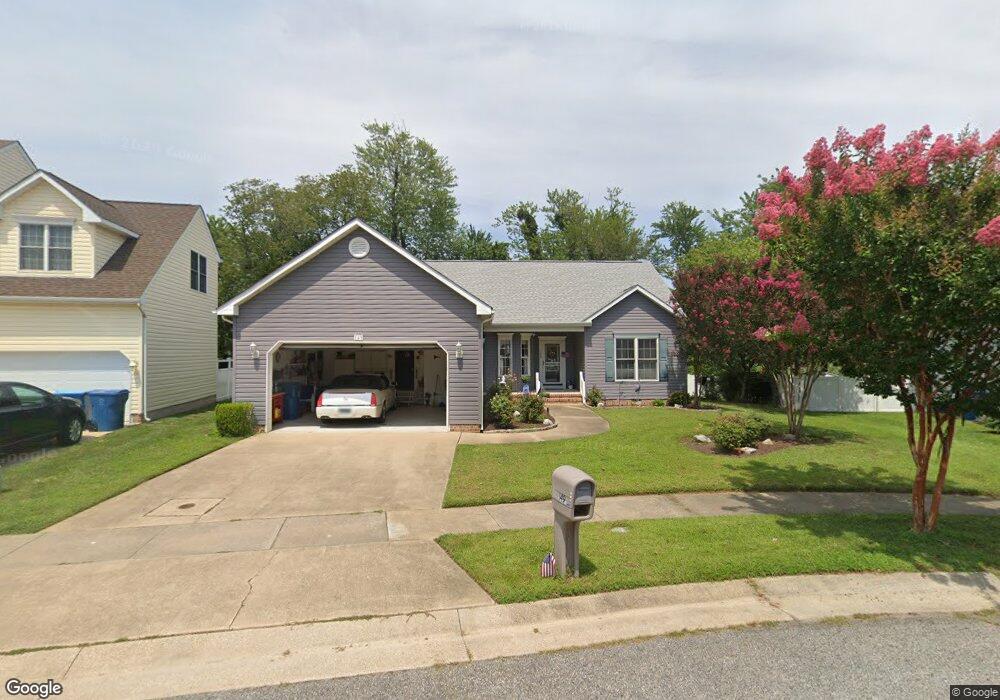
149 Mainsail Dr Stevensville, MD 21666
Estimated Value: $514,450 - $580,000
3
Beds
2
Baths
1,881
Sq Ft
$296/Sq Ft
Est. Value
About This Home
This home is located at 149 Mainsail Dr, Stevensville, MD 21666 and is currently estimated at $556,863, approximately $296 per square foot. 149 Mainsail Dr is a home located in Queen Anne's County with nearby schools including Kent Island Elementary School, Bayside Elementary School, and Matapeake Middle School.
Ownership History
Date
Name
Owned For
Owner Type
Purchase Details
Closed on
Apr 28, 2025
Sold by
Waterman Realty Company
Bought by
Solis Evelyn M and Turner Sherri
Current Estimated Value
Purchase Details
Closed on
Feb 27, 2024
Sold by
Solis Evelyn M and Solis Marin
Bought by
Solis Evelyn M and Turner Sherri L
Purchase Details
Closed on
Nov 8, 2010
Sold by
Lee Peter B and Lee Phyllis A
Bought by
Solis Marin and Solis Evelyn M
Home Financials for this Owner
Home Financials are based on the most recent Mortgage that was taken out on this home.
Original Mortgage
$90,000
Interest Rate
4.39%
Mortgage Type
New Conventional
Purchase Details
Closed on
Dec 30, 2002
Sold by
Davidson Development Inc
Bought by
Lee Peter B and Lee Phyllis A
Create a Home Valuation Report for This Property
The Home Valuation Report is an in-depth analysis detailing your home's value as well as a comparison with similar homes in the area
Home Values in the Area
Average Home Value in this Area
Purchase History
| Date | Buyer | Sale Price | Title Company |
|---|---|---|---|
| Solis Evelyn M | -- | None Listed On Document | |
| Solis Evelyn M | -- | None Listed On Document | |
| Solis Evelyn M | -- | None Listed On Document | |
| Solis Marin | $355,000 | -- | |
| Lee Peter B | $257,395 | -- |
Source: Public Records
Mortgage History
| Date | Status | Borrower | Loan Amount |
|---|---|---|---|
| Previous Owner | Solis Marin | $90,000 | |
| Closed | Lee Peter B | -- |
Source: Public Records
Tax History Compared to Growth
Tax History
| Year | Tax Paid | Tax Assessment Tax Assessment Total Assessment is a certain percentage of the fair market value that is determined by local assessors to be the total taxable value of land and additions on the property. | Land | Improvement |
|---|---|---|---|---|
| 2025 | $2,207 | $408,967 | $0 | $0 |
| 2024 | $3,600 | $386,233 | $0 | $0 |
| 2023 | $3,424 | $363,500 | $165,400 | $198,100 |
| 2022 | $3,424 | $363,500 | $165,400 | $198,100 |
| 2021 | $2,951 | $363,500 | $165,400 | $198,100 |
| 2020 | $3,533 | $368,400 | $160,400 | $208,000 |
| 2019 | $3,407 | $355,267 | $0 | $0 |
| 2018 | $3,281 | $342,133 | $0 | $0 |
| 2017 | $3,155 | $329,000 | $0 | $0 |
| 2016 | -- | $317,033 | $0 | $0 |
| 2015 | $1,541 | $305,067 | $0 | $0 |
| 2014 | $1,541 | $293,100 | $0 | $0 |
Source: Public Records
Map
Nearby Homes
- 1 UNIT 2 Compass Cir
- 1839 Harbor Dr
- 122 E Main St
- 1757 Harbor Dr
- 241 Jessica Lyn Ave
- 515 Love Point Rd
- 1870 Harbor Dr
- 111 Keenan Way
- 119 Keenan Way
- 1906 Harbor Dr
- 0 Harbor Dr
- 102 Bobbitt Ct
- 619 Love Point Rd
- 858 Moorings Cir Unit 11
- 736 Moorings Cir Unit 35
- 1916 Stevens Dr
- 349 Topside Dr
- 2653 Cox Neck Rd
- 298 Moorings Cir
- 312 Topside Dr Unit 223
- 145 Mainsail Dr
- 155 Mainsail Dr
- 139 Mainsail Dr
- 203 Mainsail Dr
- 204 Mainsail Dr
- 135 Mainsail Dr
- 207 Mainsail Dr
- 208 Mainsail Dr
- 134 Mainsail Dr
- 213 Mainsail Dr
- 127 Mainsail Dr
- 112 Mainsail Dr
- 216 Mainsail Dr
- 106 Mainsail Dr
- 219 Mainsail Dr
- 222 Mainsail Dr
- 425 Thompson Creek Rd
- 117 Mainsail Dr
- 419 Thompson Creek Rd
- 102 Mainsail Dr