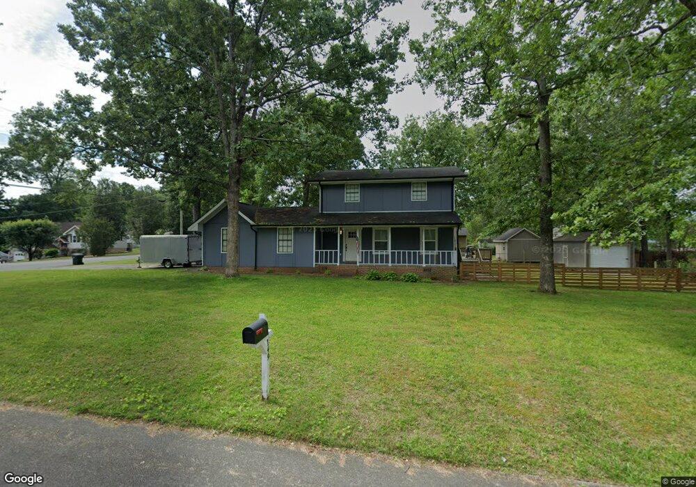
149 Pinewood Ln Fort Oglethorpe, GA 30742
Estimated Value: $207,000 - $296,000
3
Beds
2
Baths
1,550
Sq Ft
$169/Sq Ft
Est. Value
About This Home
This home is located at 149 Pinewood Ln, Fort Oglethorpe, GA 30742 and is currently estimated at $261,402, approximately $168 per square foot. 149 Pinewood Ln is a home located in Catoosa County with nearby schools including Battlefield Primary School, Battlefield Elementary School, and Lakeview Middle School.
Ownership History
Date
Name
Owned For
Owner Type
Purchase Details
Closed on
Feb 25, 2008
Sold by
Shrum Ronald
Bought by
Condroski Victor A and Condroski Charity A
Current Estimated Value
Home Financials for this Owner
Home Financials are based on the most recent Mortgage that was taken out on this home.
Original Mortgage
$125,000
Outstanding Balance
$76,696
Interest Rate
5.46%
Mortgage Type
New Conventional
Estimated Equity
$184,706
Create a Home Valuation Report for This Property
The Home Valuation Report is an in-depth analysis detailing your home's value as well as a comparison with similar homes in the area
Home Values in the Area
Average Home Value in this Area
Purchase History
| Date | Buyer | Sale Price | Title Company |
|---|---|---|---|
| Condroski Victor A | $125,000 | -- |
Source: Public Records
Mortgage History
| Date | Status | Borrower | Loan Amount |
|---|---|---|---|
| Open | Condroski Victor A | $125,000 |
Source: Public Records
Tax History Compared to Growth
Tax History
| Year | Tax Paid | Tax Assessment Tax Assessment Total Assessment is a certain percentage of the fair market value that is determined by local assessors to be the total taxable value of land and additions on the property. | Land | Improvement |
|---|---|---|---|---|
| 2024 | $2,389 | $94,310 | $10,882 | $83,428 |
| 2023 | $1,992 | $74,529 | $10,882 | $63,647 |
| 2022 | $1,446 | $55,092 | $10,882 | $44,210 |
| 2021 | $1,334 | $53,813 | $10,882 | $42,931 |
| 2020 | $1,307 | $44,277 | $9,893 | $34,384 |
| 2019 | $1,210 | $44,277 | $9,893 | $34,384 |
| 2018 | $1,388 | $44,277 | $9,893 | $34,384 |
| 2017 | $1,264 | $44,028 | $9,893 | $34,135 |
| 2016 | $1,243 | $41,624 | $9,893 | $31,731 |
| 2015 | -- | $41,624 | $9,893 | $31,731 |
| 2014 | -- | $41,624 | $9,893 | $31,731 |
| 2013 | -- | $41,624 | $9,893 | $31,731 |
Source: Public Records
Map
Nearby Homes
- 129 Cedar Grove Ln
- 300 Dogwood Ln
- 301 Dogwood Ln
- 325 Mockingbird Ln
- 2 Janet Ln
- 2237 Cloud Springs Rd
- 17 Southshore Dr
- 1305 Park Forrest Dr
- 0 Battlefield Pkwy Unit 129870
- 199 Mitchell Ln
- 6 Rocky Ford Rd
- 351 Franklin Cir
- 124 Colony Cir
- 114 Clara Lee Dr
- 17 Evergreen Cir
- 64 Stovall St
- 18 Evergreen Cir
- 14 Evergreen Cir
- 518 Winchester Dr
- 458 Winchester Dr
- 3021 Westside Country Dr
- 0 Westside Country Dr Unit 975472
- 0 Westside Country Dr Unit RTC2709798
- 0 Westside Country Dr Unit 10337332
- 0 Westside Country Dr Unit 7419885
- 0 Westside Country Dr Unit RTC2663738
- 0 Westside Country Dr Unit 1390886
- 0 Westside Country Dr Unit 1367566
- 0 Westside Country Dr Unit 1367564
- 0 Westside Country Dr Unit 1367560
- 0 Westside Country Dr Unit 8065114
- 147 Pinewood Ln
- 3017 Westside Country Dr
- 201 Primrose Ln
- 1808 Honeysuckle Ln
- 1806 Honeysuckle Ln
- 20 Primrose Ln
- 0 Primrose Ln
- 0 Primrose Ln Unit 1367572
- 0 Primrose Ln Unit 1367571