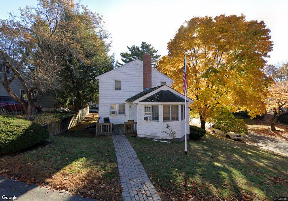
149 Woodside Ln Arlington, MA 02474
Arlington Heights NeighborhoodEstimated Value: $1,004,000 - $1,164,000
3
Beds
2
Baths
1,790
Sq Ft
$620/Sq Ft
Est. Value
About This Home
This home is located at 149 Woodside Ln, Arlington, MA 02474 and is currently estimated at $1,109,476, approximately $619 per square foot. 149 Woodside Ln is a home located in Middlesex County with nearby schools including M. Norcross Stratton Elementary School, Ottoson Middle School, and Arlington High School.
Ownership History
Date
Name
Owned For
Owner Type
Purchase Details
Closed on
Jun 26, 2025
Sold by
Flaherty Francis X
Bought by
149 Woodside Lane Rt and Flaherty
Current Estimated Value
Purchase Details
Closed on
Sep 17, 2007
Sold by
Flaherty M Maureen
Bought by
Flaherty Francis X and Flaherty Maureen M
Create a Home Valuation Report for This Property
The Home Valuation Report is an in-depth analysis detailing your home's value as well as a comparison with similar homes in the area
Home Values in the Area
Average Home Value in this Area
Purchase History
| Date | Buyer | Sale Price | Title Company |
|---|---|---|---|
| 149 Woodside Lane Rt | -- | -- | |
| 149 Woodside Lane Rt | -- | -- | |
| Flaherty Francis X | -- | -- | |
| Flaherty Francis X | -- | -- |
Source: Public Records
Mortgage History
| Date | Status | Borrower | Loan Amount |
|---|---|---|---|
| Previous Owner | Flaherty Francis X | $117,000 | |
| Previous Owner | Flaherty Francis X | $80,000 | |
| Previous Owner | Flaherty Francis X | $65,853 |
Source: Public Records
Tax History Compared to Growth
Tax History
| Year | Tax Paid | Tax Assessment Tax Assessment Total Assessment is a certain percentage of the fair market value that is determined by local assessors to be the total taxable value of land and additions on the property. | Land | Improvement |
|---|---|---|---|---|
| 2025 | $10,024 | $930,700 | $504,200 | $426,500 |
| 2024 | $9,443 | $891,700 | $498,100 | $393,600 |
| 2023 | $9,062 | $808,400 | $448,900 | $359,500 |
| 2022 | $8,757 | $766,800 | $430,400 | $336,400 |
| 2021 | $8,586 | $757,100 | $430,400 | $326,700 |
| 2020 | $8,374 | $757,100 | $430,400 | $326,700 |
| 2019 | $7,656 | $679,900 | $436,600 | $243,300 |
| 2018 | $6,904 | $569,200 | $325,900 | $243,300 |
| 2017 | $6,762 | $538,400 | $295,100 | $243,300 |
| 2016 | $6,734 | $526,100 | $282,800 | $243,300 |
| 2015 | $6,465 | $477,100 | $239,800 | $237,300 |
Source: Public Records
Map
Nearby Homes
- 37 Pine St
- 12 Longmeadow Rd
- 52-56 Dudley St
- 18-20 Brattle St
- 455 Summer St Unit 455
- 975 Mass Ave Unit 106
- 975 Massachusetts Ave Unit 307
- 335 Mystic St
- 995 Massachusetts Ave Unit 404
- 1025 Massachusetts Ave Unit 204
- 204 Plan at Majestic Mill Brook
- 1025 Massachusetts Ave Unit 404
- 1025 Massachusetts Ave Unit 506
- 1025 Massachusetts Ave Unit 401
- 1025 Massachusetts Ave Unit 210
- 1025 Massachusetts Ave Unit 402
- 1025 Massachusetts Ave Unit 308
- 1025 Massachusetts Ave Unit 411
- 1025 Massachusetts Ave Unit 313
- 1025 Massachusetts Ave Unit 304
- 157 Woodside Ln
- 143 Woodside Ln
- 146 Woodside Ln
- 154 Woodside Ln
- 142 Woodside Ln
- 158 Woodside Ln
- 163 Woodside Ln
- 150 Woodside Ln
- 139 Woodside Ln
- 162 Woodside Ln
- 138 Woodside Ln
- 70 Lansdowne Rd
- 57 Lansdowne Rd
- 167 Woodside Ln
- 46 Rockland Ave
- 135 Woodside Ln
- 134 Woodside Ln
- 166 Woodside Ln
- 19 Jeffrey Rd
- 49 Rockland Ave