Estimated Value: $534,878 - $547,000
3
Beds
2
Baths
1,657
Sq Ft
$328/Sq Ft
Est. Value
About This Home
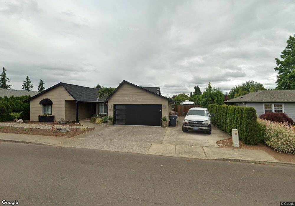
This home is located at 1490 N Locust St, Canby, OR 97013 and is currently estimated at $543,220, approximately $327 per square foot. 1490 N Locust St is a home located in Clackamas County with nearby schools including Howard Eccles Elementary School, Baker Prairie Middle School, and Canby High School.
Ownership History
Date
Name
Owned For
Owner Type
Purchase Details
Closed on
Sep 29, 2015
Sold by
Goergens Merlene E
Bought by
Theim Gregory C and Theim Kimberli A
Current Estimated Value
Home Financials for this Owner
Home Financials are based on the most recent Mortgage that was taken out on this home.
Original Mortgage
$268,620
Outstanding Balance
$213,964
Interest Rate
4.25%
Mortgage Type
FHA
Estimated Equity
$329,256
Purchase Details
Closed on
Oct 14, 1998
Sold by
Wolfer Robert C and Wolfer Tamra L
Bought by
Goergens Merlene E
Create a Home Valuation Report for This Property
The Home Valuation Report is an in-depth analysis detailing your home's value as well as a comparison with similar homes in the area
Home Values in the Area
Average Home Value in this Area
Purchase History
| Date | Buyer | Sale Price | Title Company |
|---|---|---|---|
| Theim Gregory C | $274,000 | Ticor Title | |
| Goergens Merlene E | $165,000 | Pacific Nw Title |
Source: Public Records
Mortgage History
| Date | Status | Borrower | Loan Amount |
|---|---|---|---|
| Open | Theim Gregory C | $268,620 |
Source: Public Records
Tax History Compared to Growth
Tax History
| Year | Tax Paid | Tax Assessment Tax Assessment Total Assessment is a certain percentage of the fair market value that is determined by local assessors to be the total taxable value of land and additions on the property. | Land | Improvement |
|---|---|---|---|---|
| 2024 | $5,331 | $300,582 | -- | -- |
| 2023 | $5,331 | $267,321 | $0 | $0 |
| 2022 | $4,492 | $259,535 | $0 | $0 |
| 2021 | $4,325 | $251,976 | $0 | $0 |
| 2020 | $4,248 | $244,637 | $0 | $0 |
| 2019 | $4,045 | $237,512 | $0 | $0 |
| 2018 | $3,955 | $230,594 | $0 | $0 |
| 2017 | $3,855 | $223,878 | $0 | $0 |
| 2016 | $3,726 | $217,357 | $0 | $0 |
| 2015 | $3,265 | $211,026 | $0 | $0 |
| 2014 | $3,171 | $204,880 | $0 | $0 |
Source: Public Records
Map
Nearby Homes
- 312 NE 14th Ave
- 1725 N Laurelwood Loop
- 187 NE 14th Ave
- 1240 N Juniper St
- 1721 N Hyssop St
- 142 NE 11th Ave
- 184 NE 10th Ave
- 832 NE 17th Ave
- 853 NE 17th Ave
- 838 NE 17th Ave
- 844 NE 17th Ave
- 860 NE 14th Ave
- 2152 N Laurelwood St
- 947 NE 17th Ave
- 952 NE 17th Ave
- 878 NE 17th Ave
- 1762 N Oak St
- 1009 NE 17th Ave
- 0 NW 10th Ave
- 1258 NE 17th Ave
- 1510 N Locust St
- 1478 N Locust St
- 1531 NE Laurelwood Cir
- 1529 NE Laurelwood Cir
- 1473 N Locust St
- 306 NE 14th Ave
- 1530 N Locust St
- 1467 N Locust St
- 1517 N Locust St
- 1533 NE Laurelwood Cir
- 1535 N Locust St
- 320 NE 14th Ave
- 1485 N Locust St
- 1560 N Locust St
- 1421 N Locust St
- 1505 N Locust St
- 1449 N Locust St
- 1519 NE Laurelwood Cir
- 332 NE 14th Ave
- 1555 N Locust St