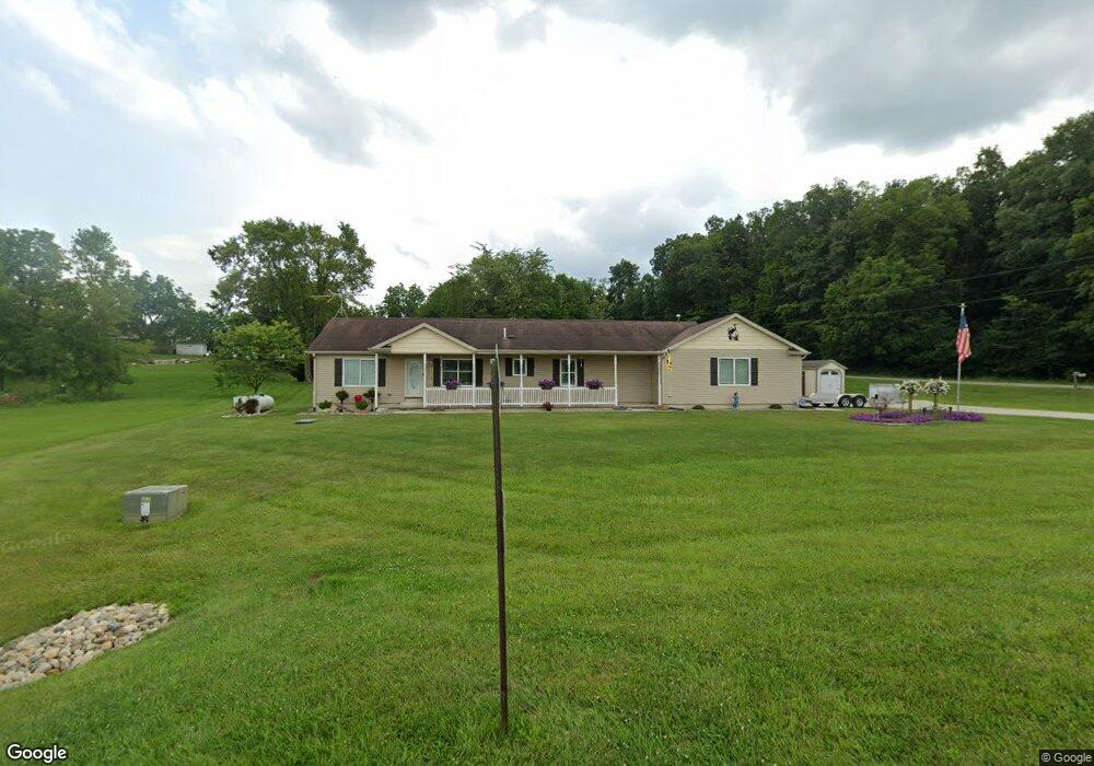
14911 Woodbridge Rd Camden, MI 49232
Estimated Value: $410,000 - $521,000
3
Beds
2
Baths
1,620
Sq Ft
$284/Sq Ft
Est. Value
About This Home
This home is located at 14911 Woodbridge Rd, Camden, MI 49232 and is currently estimated at $460,845, approximately $284 per square foot. 14911 Woodbridge Rd is a home located in Hillsdale County with nearby schools including Camden-Frontier High School and Camden-Frontier K-8 School.
Ownership History
Date
Name
Owned For
Owner Type
Purchase Details
Closed on
Nov 17, 2010
Sold by
Century Bank & Trust
Bought by
Gonder Lawrence A and Gonder Susan Lynn
Current Estimated Value
Purchase Details
Closed on
Sep 22, 2010
Sold by
Century Mortgage Services Inc
Bought by
Century Bank & Trust
Purchase Details
Closed on
Mar 29, 2010
Sold by
Carter Lyn Mae and Carter Lyn M
Bought by
Century Mortgage Services Inc
Purchase Details
Closed on
Nov 2, 2001
Sold by
Gulick Augustus I
Bought by
Carter Lyn M
Purchase Details
Closed on
Mar 7, 2000
Sold by
Carter Harley and Carter Lyn M
Bought by
Gulick Augustus I and Carter Lyn M
Purchase Details
Closed on
Jun 21, 1996
Sold by
Carter Harley and Lyn Mae
Bought by
Carter Harley and Lyn Mae
Create a Home Valuation Report for This Property
The Home Valuation Report is an in-depth analysis detailing your home's value as well as a comparison with similar homes in the area
Home Values in the Area
Average Home Value in this Area
Purchase History
| Date | Buyer | Sale Price | Title Company |
|---|---|---|---|
| Gonder Lawrence A | $125,000 | Public Title Agency | |
| Century Bank & Trust | -- | None Available | |
| Century Mortgage Services Inc | -- | None Available | |
| Carter Lyn M | -- | -- | |
| Gulick Augustus I | -- | -- | |
| Carter Harley | -- | -- |
Source: Public Records
Tax History Compared to Growth
Tax History
| Year | Tax Paid | Tax Assessment Tax Assessment Total Assessment is a certain percentage of the fair market value that is determined by local assessors to be the total taxable value of land and additions on the property. | Land | Improvement |
|---|---|---|---|---|
| 2025 | $2,918 | $197,200 | $0 | $0 |
| 2024 | $1,173 | $232,400 | $0 | $0 |
| 2023 | $1,117 | $171,300 | $0 | $0 |
| 2022 | $2,800 | $139,400 | $0 | $0 |
| 2021 | $2,736 | $140,100 | $0 | $0 |
| 2020 | $2,767 | $138,300 | $0 | $0 |
| 2019 | $2,634 | $128,000 | $0 | $0 |
| 2018 | $2,537 | $122,700 | $0 | $0 |
| 2017 | $2,414 | $122,370 | $0 | $0 |
| 2016 | $2,400 | $119,660 | $0 | $0 |
| 2015 | $941 | $119,660 | $0 | $0 |
| 2013 | $905 | $84,860 | $0 | $0 |
| 2012 | $883 | $80,640 | $0 | $0 |
Source: Public Records
Map
Nearby Homes
- 14934 Heather Ct
- 14364 Horn Dr
- 13551 Hillsdale Rd
- 623-624 Yuma Trail
- 0 W Territorial Rd Unit 25043960
- 0 W Territorial Rd Unit 11603977
- 988-989 Seneca Dr
- 0 Pontiac Trail Unit 10001711
- 207 Modoc Trail
- 213 Navajo Trail
- 155 Navajo Trail
- 600 Seneca Dr
- 234 Seneca Dr
- 638 Seneca Dr
- 131 Choctaw Trail
- 145 Lumbee Ln
- 14621 Laura Ln
- 4002 & 4014 Meadowlawn Dr
- 16993 County Road 12
- 4324 Oak Glen Dr
- 14951 Woodbridge Rd
- 2440 Mindy Ln
- 2410 Mindy Ln
- 14861 Woodbridge Rd
- 2370 Mindy Ln
- 14900 Woodbridge Rd
- 2480 W Territorial Rd
- 14769 Woodbridge Rd
- 14759 Woodbridge Rd
- 2367 Mindy Ln
- 14939 Heather Ct
- 2348 Mindy Ln
- 14911 Heather Ct
- 14955 Heather Ct
- 2351 Mindy Ln
- 2326 Mindy Ln
- 2671 W Territorial Rd
- 2300 Mindy Ln
- 2323 Mindy Ln
- 14705 Woodbridge Rd