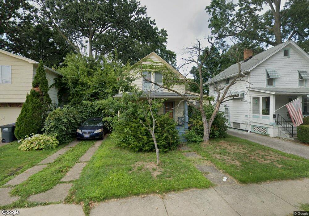
14916 Lanning Ave Lakewood, OH 44107
Estimated Value: $190,503 - $288,000
2
Beds
1
Bath
951
Sq Ft
$240/Sq Ft
Est. Value
About This Home
This home is located at 14916 Lanning Ave, Lakewood, OH 44107 and is currently estimated at $228,126, approximately $239 per square foot. 14916 Lanning Ave is a home located in Cuyahoga County with nearby schools including Hayes Elementary School, Harding Middle School, and Lakewood High School.
Ownership History
Date
Name
Owned For
Owner Type
Purchase Details
Closed on
Oct 15, 1991
Sold by
Hamm Paul W
Bought by
Ellis Mary Ann
Current Estimated Value
Purchase Details
Closed on
Apr 20, 1990
Sold by
Thoms Raymond L
Bought by
Hamm Paul W
Purchase Details
Closed on
Apr 14, 1988
Sold by
Timms Loretta A
Bought by
Thoms Raymond L
Purchase Details
Closed on
Mar 24, 1987
Sold by
Wolfe Roberta Ruth
Bought by
Timms Loretta A
Purchase Details
Closed on
Nov 29, 1978
Sold by
Wolfe Carl L
Bought by
Wolfe Roberta Ruth
Purchase Details
Closed on
Jan 1, 1975
Bought by
Wolfe Carl L
Create a Home Valuation Report for This Property
The Home Valuation Report is an in-depth analysis detailing your home's value as well as a comparison with similar homes in the area
Home Values in the Area
Average Home Value in this Area
Purchase History
| Date | Buyer | Sale Price | Title Company |
|---|---|---|---|
| Ellis Mary Ann | $50,000 | -- | |
| Hamm Paul W | $45,000 | -- | |
| Thoms Raymond L | $32,000 | -- | |
| Timms Loretta A | -- | -- | |
| Wolfe Roberta Ruth | -- | -- | |
| Wolfe Carl L | -- | -- |
Source: Public Records
Tax History Compared to Growth
Tax History
| Year | Tax Paid | Tax Assessment Tax Assessment Total Assessment is a certain percentage of the fair market value that is determined by local assessors to be the total taxable value of land and additions on the property. | Land | Improvement |
|---|---|---|---|---|
| 2024 | $2,702 | $51,870 | $18,200 | $33,670 |
| 2023 | $3,179 | $51,520 | $15,120 | $36,400 |
| 2022 | $3,231 | $51,520 | $15,120 | $36,400 |
| 2021 | $3,198 | $51,520 | $15,120 | $36,400 |
| 2020 | $2,668 | $39,940 | $11,730 | $28,210 |
| 2019 | $2,615 | $114,100 | $33,500 | $80,600 |
| 2018 | $2,611 | $39,940 | $11,730 | $28,210 |
| 2017 | $1,825 | $28,560 | $8,960 | $19,600 |
| 2016 | $1,813 | $28,560 | $8,960 | $19,600 |
| 2015 | $1,784 | $28,560 | $8,960 | $19,600 |
| 2014 | $1,784 | $27,480 | $8,610 | $18,870 |
Source: Public Records
Map
Nearby Homes
- 14926 Esther Ave
- 14909 Arden Ave
- 14924 Delaware Ave
- 2209 Alger Rd
- 14924 Arden Ave
- 2230 Alger Rd
- 2165 Arthur Ave
- 2263 Warren Rd
- 14428 Delaware Ave
- 14404 Bayes Ave
- 15615 Fernway Ave
- 2078 Baxterly Ave
- 2234 Olive Ave
- 15555 Hilliard Rd Unit 401A
- 2099 Olive Ave
- 2209 Woodward Ave
- 2239 Woodward Ave
- 14426 Alger Rd
- 1578 Mars Ave
- 1594 Victoria Ave
- 14912 Lanning Ave
- 14924 Lanning Ave
- 2180 Alger Rd
- 2188 Alger Rd
- 15102 Lanning Ave
- 14915 Esther Ave
- 2174 Alger Rd
- 14919 Esther Ave
- 14911 Lanning Ave
- 15106 Lanning Ave
- 14917 Lanning Ave
- 14921 Lanning Ave
- 14923 Esther Ave
- 2200 Alger Rd
- 14925 Lanning Ave
- 2172 Alger Rd
- 15110 Lanning Ave
- 14927 Esther Ave
- 15103 Lanning Ave
- 2204 Alger Rd