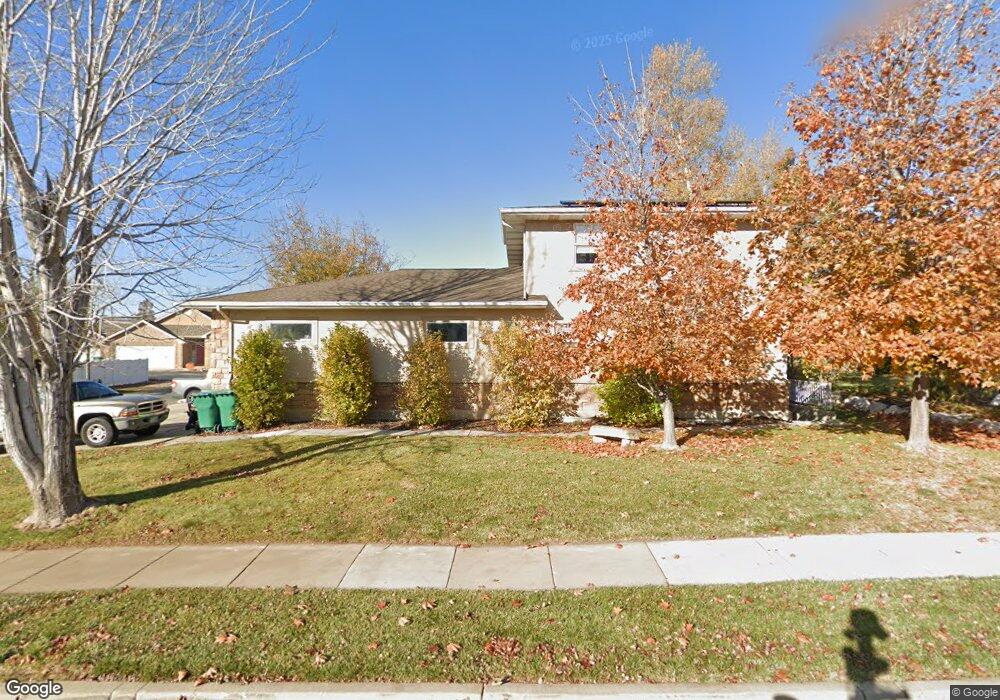
1499 E 575 N Layton, UT 84040
Estimated Value: $688,000 - $876,000
--
Bed
4
Baths
2,725
Sq Ft
$290/Sq Ft
Est. Value
About This Home
This home is located at 1499 E 575 N, Layton, UT 84040 and is currently estimated at $791,402, approximately $290 per square foot. 1499 E 575 N is a home located in Davis County with nearby schools including King Elementary School, Central Davis Junior High School, and Layton High School.
Ownership History
Date
Name
Owned For
Owner Type
Purchase Details
Closed on
Aug 18, 2010
Sold by
Parry Virginia A
Bought by
Parry Virginia A
Current Estimated Value
Home Financials for this Owner
Home Financials are based on the most recent Mortgage that was taken out on this home.
Original Mortgage
$211,000
Interest Rate
4.04%
Mortgage Type
New Conventional
Purchase Details
Closed on
Mar 9, 2000
Sold by
Ramsdell Michael A and Ramsdell Bonnie L
Bought by
Parry Virginia A
Create a Home Valuation Report for This Property
The Home Valuation Report is an in-depth analysis detailing your home's value as well as a comparison with similar homes in the area
Home Values in the Area
Average Home Value in this Area
Purchase History
| Date | Buyer | Sale Price | Title Company |
|---|---|---|---|
| Parry Virginia A | -- | Hickman Land Title Co | |
| Parry Virginia A | -- | Backman Stewart Title Servic |
Source: Public Records
Mortgage History
| Date | Status | Borrower | Loan Amount |
|---|---|---|---|
| Closed | Parry Virginia A | $211,000 |
Source: Public Records
Tax History
| Year | Tax Paid | Tax Assessment Tax Assessment Total Assessment is a certain percentage of the fair market value that is determined by local assessors to be the total taxable value of land and additions on the property. | Land | Improvement |
|---|---|---|---|---|
| 2025 | $4,450 | $435,050 | $129,202 | $305,848 |
| 2024 | $4,171 | $410,850 | $152,197 | $258,653 |
| 2023 | $4,142 | $723,000 | $203,420 | $519,580 |
| 2022 | $4,302 | $410,300 | $109,271 | $301,029 |
| 2021 | $3,973 | $564,000 | $166,551 | $397,449 |
| 2020 | $3,649 | $496,000 | $135,858 | $360,142 |
| 2019 | $3,836 | $515,000 | $121,146 | $393,854 |
| 2018 | $3,563 | $480,000 | $95,086 | $384,914 |
| 2016 | $3,306 | $232,760 | $49,884 | $182,876 |
| 2015 | $3,287 | $219,835 | $49,884 | $169,951 |
| 2014 | $3,317 | $227,116 | $49,884 | $177,232 |
| 2013 | -- | $200,390 | $37,224 | $163,166 |
Source: Public Records
Map
Nearby Homes
- 1503 E 530 N
- 1545 E 975 N
- 1690 E Gentile St
- 479 N 1375 E
- 1515 E Gentile St
- 1033 E 825 N
- 2877 E Gentile St Unit 2
- 997 E 825 N
- 508 N Adamswood Rd
- 556 N Fairfield Rd Unit A2
- 556 N Fairfield Rd Unit D1
- 556 N Fairfield Rd Unit D2
- 556 N Fairfield Rd Unit A3
- 556 N Fairfield Rd Unit D3
- 556 N Fairfield Rd Unit D4
- 556 N Fairfield Rd Unit A1
- 556 N Fairfield Rd Unit A4
- 861 E 575 N
- 1258 E North Lisa St
- 187 N Talbot Dr
- 1499 E 575 N Unit 707
- 1513 E 575 N
- 1479 E 575 N
- 1479 E 575 N Unit 706
- 1498 E 575 N
- 1497 E 575 N
- 1491 E 575 N
- 1491 E 575 N Unit 705
- 1512 E 575 N
- 1474 E 575 N
- 1463 E 575 N
- 1531 E 575 N
- 1530 E 575 N
- 752 Ash Dr
- 1470 E 625 N
- 1470 E 625 N Unit 17
- 752 N 1475 E Unit 701
- 1452 E 575 N
- 1453 E 525 N
- 590 N 1425 E
Your Personal Tour Guide
Ask me questions while you tour the home.