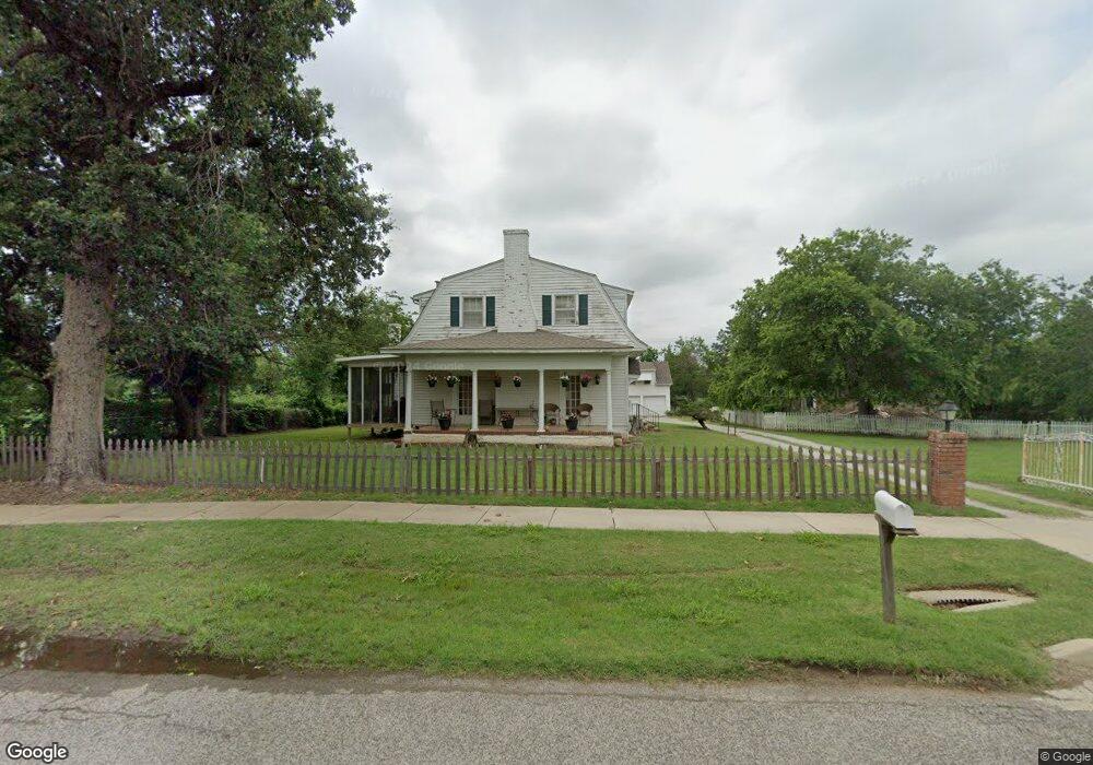
1499 Tim Holt Dr Harrah, OK 73045
Estimated Value: $179,000 - $269,340
3
Beds
2
Baths
2,440
Sq Ft
$92/Sq Ft
Est. Value
About This Home
This home is located at 1499 Tim Holt Dr, Harrah, OK 73045 and is currently estimated at $225,085, approximately $92 per square foot. 1499 Tim Holt Dr is a home located in Oklahoma County with nearby schools including Virginia Smith Elementary School, Russell Babb Elementary School, and Clara Reynolds Elementary School.
Ownership History
Date
Name
Owned For
Owner Type
Purchase Details
Closed on
Apr 26, 2010
Sold by
Deutsche Bank National Trust Company
Bought by
Hunter Family Properties
Current Estimated Value
Purchase Details
Closed on
Jan 11, 2010
Sold by
Banning Mark A and Banning Michelle L
Bought by
Deutsche Bank National Trust Company
Purchase Details
Closed on
Feb 28, 2006
Sold by
Gregory Ted W and Gregory Juanita M
Bought by
Banning Mark A and Banning Michele L
Home Financials for this Owner
Home Financials are based on the most recent Mortgage that was taken out on this home.
Original Mortgage
$27,700
Interest Rate
6.19%
Mortgage Type
Stand Alone Second
Purchase Details
Closed on
Nov 27, 2002
Sold by
Mcclurg Orville G
Bought by
Gregory Ted W and Gregory Juanita M
Create a Home Valuation Report for This Property
The Home Valuation Report is an in-depth analysis detailing your home's value as well as a comparison with similar homes in the area
Home Values in the Area
Average Home Value in this Area
Purchase History
| Date | Buyer | Sale Price | Title Company |
|---|---|---|---|
| Hunter Family Properties | $75,500 | First American Title | |
| Deutsche Bank National Trust Company | -- | None Available | |
| Banning Mark A | $138,500 | Stewart Escrow & Title Midwe | |
| Gregory Ted W | $108,000 | Stewart Escrow & Title | |
| Royse Gary L | -- | Stewart Escrow & Title |
Source: Public Records
Mortgage History
| Date | Status | Borrower | Loan Amount |
|---|---|---|---|
| Previous Owner | Banning Mark A | $27,700 | |
| Previous Owner | Banning Mark A | $110,800 |
Source: Public Records
Tax History Compared to Growth
Tax History
| Year | Tax Paid | Tax Assessment Tax Assessment Total Assessment is a certain percentage of the fair market value that is determined by local assessors to be the total taxable value of land and additions on the property. | Land | Improvement |
|---|---|---|---|---|
| 2024 | $1,720 | $18,450 | $2,122 | $16,328 |
| 2023 | $1,720 | $17,571 | $1,928 | $15,643 |
| 2022 | $1,665 | $16,735 | $2,040 | $14,695 |
| 2021 | $1,586 | $15,939 | $4,540 | $11,399 |
| 2020 | $1,551 | $15,180 | $4,778 | $10,402 |
| 2019 | $1,566 | $15,345 | $4,778 | $10,567 |
| 2018 | $1,623 | $15,620 | $0 | $0 |
| 2017 | $1,594 | $15,649 | $4,310 | $11,339 |
| 2016 | $1,546 | $14,904 | $4,332 | $10,572 |
| 2015 | $1,692 | $16,473 | $4,332 | $12,141 |
| 2014 | $1,740 | $16,980 | $4,332 | $12,648 |
Source: Public Records
Map
Nearby Homes
- Maple Plan at Brush Creek
- Lilac Plan at Brush Creek
- Rosemary Plan at Brush Creek
- Bradford Plan at Brush Creek
- Lavender Plan at Brush Creek
- 1487 N 1st St
- 1650 N 1st St
- 1239 N 2nd St
- 2220 Church Ave
- 20629 Twisted Oak Rd
- 972 Tim Holt Dr
- 20687 Brush Creek Blvd
- 20675 Brush Creek Blvd
- 20661 Brush Creek Blvd
- 20657 Brush Creek Blvd
- 20653 Brush Creek Blvd
- 20649 Brush Creek Blvd
- 20645 Brush Creek Blvd
- 900 Harrison St
- 20684 Brush Creek Blvd