
Seller's Agent in 2025
Kimberly Allard
Century 21 Professionals
(781) 844-8870
1 in this area
78 Total Sales
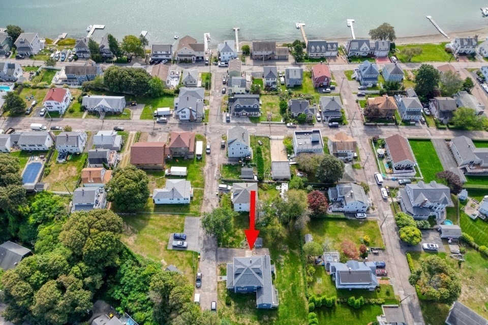


Welcome ! This 6-bedroom, 3-bath Colonial offers over 2,500 sq ft of living space on a rare dead-end/0.37-acre lot in the desirable Whitehead neighborhood. This home offers character w/recent updates: AC, Newer Roof/Siding/Windows, New Heating, and hardwood floors throughout. Sun-filled rooms, a flexible layout, w/a bathroom on each level, a partially finished basement w/ large studio area, full bath, kitchenette and separate entrance, make this home both functional and inviting. 1st floor features electric blinds, wood stove & 2 bedrooms, while the 2nd floor has 3/4 bedrooms with a wet bar & extra fridge for essentials. Enjoy the bright enclosed sun porch & 2 decks/balconies that overlook the neighborhood. Outside, you’ll find two sheds as well as expansive yard space for gardening, play, or gatherings. Minutes from Hull’s beaches and coastline, with easy access to schools, shops, and Boston commuter options, this property offers the perfect South Shore lifestyle. Not in Flood Zone
| Date | Type | Sale Price | Title Company |
|---|---|---|---|
| Quit Claim Deed | -- | -- | |
| Quit Claim Deed | -- | -- | |
| Deed | -- | -- |
| Date | Status | Loan Amount | Loan Type |
|---|---|---|---|
| Previous Owner | $99,999 | No Value Available | |
| Previous Owner | $30,000 | No Value Available |
| Date | Event | Price | List to Sale | Price per Sq Ft |
|---|---|---|---|---|
| 12/18/2025 12/18/25 | Sold | $723,000 | -3.3% | $285 / Sq Ft |
| 11/19/2025 11/19/25 | Pending | -- | -- | -- |
| 11/17/2025 11/17/25 | Price Changed | $748,000 | -6.3% | $295 / Sq Ft |
| 10/23/2025 10/23/25 | Price Changed | $798,000 | -5.3% | $315 / Sq Ft |
| 09/30/2025 09/30/25 | For Sale | $843,000 | -- | $332 / Sq Ft |
| Year | Tax Paid | Tax Assessment Tax Assessment Total Assessment is a certain percentage of the fair market value that is determined by local assessors to be the total taxable value of land and additions on the property. | Land | Improvement |
|---|---|---|---|---|
| 2025 | $7,721 | $689,400 | $338,800 | $350,600 |
| 2024 | $7,686 | $659,700 | $327,900 | $331,800 |
| 2023 | $7,537 | $619,300 | $306,000 | $313,300 |
| 2022 | $7,298 | $582,000 | $284,100 | $297,900 |
| 2021 | $6,918 | $545,600 | $251,400 | $294,200 |
| 2020 | $6,460 | $503,900 | $251,400 | $252,500 |
| 2019 | $6,329 | $485,000 | $240,400 | $244,600 |
| 2018 | $6,089 | $453,700 | $240,400 | $213,300 |
| 2017 | $6,011 | $438,100 | $240,400 | $197,700 |
| 2016 | $5,906 | $438,100 | $240,400 | $197,700 |
| 2015 | $5,575 | $399,900 | $202,200 | $197,700 |
| 2014 | $5,547 | $399,900 | $202,200 | $197,700 |
Seller's Agent in 2025
Kimberly Allard
Century 21 Professionals
(781) 844-8870
1 in this area
78 Total Sales
D
Seller Co-Listing Agent in 2025
Dawn Marsico
Century 21 Professionals
1 in this area
11 Total Sales
Buyer's Agent in 2025
Rachel Bodner
Coldwell Banker Realty - Sudbury
(978) 505-1466
1 in this area
169 Total Sales
Source: MLS Property Information Network (MLS PIN)
MLS Number: 73437491
APN: HULL-000028-000000-000127
Disclaimer: Certain information contained herein is derived from information provided by parties other than Homes.com. All information provided is deemed reliable, but is not guaranteed to be accurate and should be independently verified.
![]() The property listing data and information, or the Images, set forth herein were provided to MLS Property Information Network, Inc. from third party sources, including sellers, lessors and public records, and were compiled by MLS Property Information Network, Inc. The property listing data and information, and the Images, are for the personal, non-commercial use of consumers having a good faith interest in purchasing or leasing listed properties of the type displayed to them and may not be used for any purpose other than to identify prospective properties which such consumers may have a good faith interest in purchasing or leasing. MLS Property Information Network, Inc. and its subscribers disclaim any and all representations and warranties as to the accuracy of the property listing data and information, or as to the accuracy of any of the Images, set forth herein.
The property listing data and information, or the Images, set forth herein were provided to MLS Property Information Network, Inc. from third party sources, including sellers, lessors and public records, and were compiled by MLS Property Information Network, Inc. The property listing data and information, and the Images, are for the personal, non-commercial use of consumers having a good faith interest in purchasing or leasing listed properties of the type displayed to them and may not be used for any purpose other than to identify prospective properties which such consumers may have a good faith interest in purchasing or leasing. MLS Property Information Network, Inc. and its subscribers disclaim any and all representations and warranties as to the accuracy of the property listing data and information, or as to the accuracy of any of the Images, set forth herein.