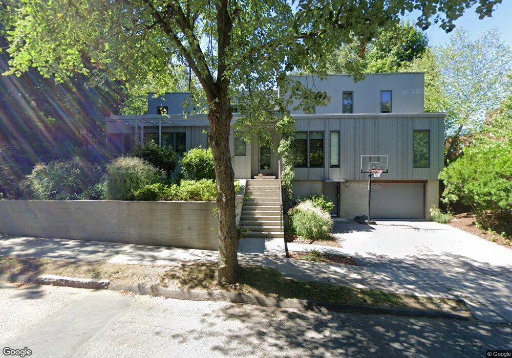
15 Borland St Brookline, MA 02446
Coolidge Corner NeighborhoodEstimated Value: $1,921,000 - $4,062,000
4
Beds
3
Baths
2,228
Sq Ft
$1,456/Sq Ft
Est. Value
About This Home
This home is located at 15 Borland St, Brookline, MA 02446 and is currently estimated at $3,242,932, approximately $1,455 per square foot. 15 Borland St is a home located in Norfolk County with nearby schools including Amos A. Lawrence School, New England Hebrew Academy, and Winsor School.
Ownership History
Date
Name
Owned For
Owner Type
Purchase Details
Closed on
Jun 6, 2018
Sold by
Rock Laura K and Rock Mitchell C
Bought by
Laura K Rock Ret
Current Estimated Value
Purchase Details
Closed on
Aug 27, 2010
Sold by
Wolfman Bernard N and Wolfman Marillyn L
Bought by
Rock Mitchell C and Rock Laura K
Home Financials for this Owner
Home Financials are based on the most recent Mortgage that was taken out on this home.
Original Mortgage
$523,750
Interest Rate
4.57%
Mortgage Type
Purchase Money Mortgage
Create a Home Valuation Report for This Property
The Home Valuation Report is an in-depth analysis detailing your home's value as well as a comparison with similar homes in the area
Home Values in the Area
Average Home Value in this Area
Purchase History
| Date | Buyer | Sale Price | Title Company |
|---|---|---|---|
| Laura K Rock Ret | -- | -- | |
| Rock Mitchell C | $1,200,000 | -- |
Source: Public Records
Mortgage History
| Date | Status | Borrower | Loan Amount |
|---|---|---|---|
| Previous Owner | Rock Mitchell C | $523,750 |
Source: Public Records
Tax History Compared to Growth
Tax History
| Year | Tax Paid | Tax Assessment Tax Assessment Total Assessment is a certain percentage of the fair market value that is determined by local assessors to be the total taxable value of land and additions on the property. | Land | Improvement |
|---|---|---|---|---|
| 2025 | $35,330 | $3,579,500 | $2,066,600 | $1,512,900 |
| 2024 | $33,572 | $3,436,200 | $1,987,100 | $1,449,100 |
| 2023 | $28,854 | $2,894,100 | $1,619,900 | $1,274,200 |
| 2022 | $28,086 | $2,756,200 | $1,542,700 | $1,213,500 |
| 2021 | $25,972 | $2,650,200 | $1,483,400 | $1,166,800 |
| 2020 | $23,310 | $2,466,700 | $1,318,900 | $1,147,800 |
| 2019 | $22,277 | $2,377,500 | $1,284,300 | $1,093,200 |
| 2018 | $21,351 | $2,257,000 | $1,129,200 | $1,127,800 |
| 2017 | $21,037 | $2,129,300 | $1,065,300 | $1,064,000 |
| 2016 | $20,736 | $1,990,000 | $995,600 | $994,400 |
| 2015 | $19,863 | $1,859,800 | $930,500 | $929,300 |
| 2014 | $19,589 | $1,719,800 | $827,500 | $892,300 |
Source: Public Records
Map
Nearby Homes
- 178 Ivy St
- 20 Chapel St Unit APH4
- 20 Chapel St Unit B712
- 20 Chapel St Unit B811
- 180 Ivy St
- 18 Browne St Unit 2
- 132 St Mary's St
- 151 Longwood Ave Unit 1
- 15 Keswick St Unit B1
- 17 James St Unit 1
- 19 Thatcher St Unit E13
- 462 Park Dr
- 79 Pleasant St Unit 4
- 125 Pleasant St Unit 201
- 60 Longwood Ave Unit 802
- 60 Longwood Ave Unit 307
- 60 Longwood Ave Unit 403
- 50 Longwood Ave Unit 611
- 116 Riverway Unit 14
- 65 Francis St Unit 65
- 15 Borland St Unit 17
- 15 Borland St Unit 45
- 21 Borland St
- 21 Borland St Unit 14
- 1131 Beacon St Unit 4
- 1131 Beacon St Unit 1
- 1131 Beacon St Unit 2
- 1131 Beacon St
- 1129 Beacon St Unit 1163
- 1141 Beacon St Unit F-12
- 1141 Beacon St Unit F-10
- 1141 Beacon St Unit 224
- 1141 Beacon St Unit 226
- 1141 Beacon St
- 10 Hawes Place
- 15 Chatham Cir
- 17 Chatham Cir
- 1111 Beacon St Unit 66
- 1111 Beacon St Unit 33
- 1111 Beacon St Unit 51