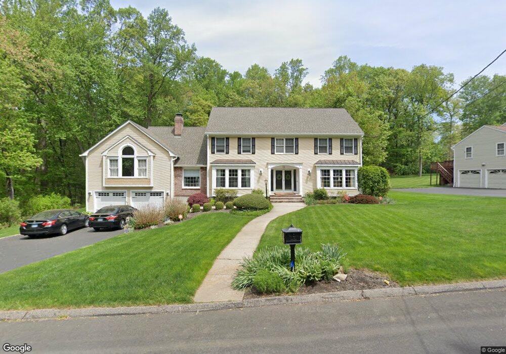
15 Canfield Dr Shelton, CT 06484
Estimated Value: $804,345 - $984,000
3
Beds
3
Baths
3,254
Sq Ft
$273/Sq Ft
Est. Value
About This Home
This home is located at 15 Canfield Dr, Shelton, CT 06484 and is currently estimated at $889,336, approximately $273 per square foot. 15 Canfield Dr is a home located in Fairfield County with nearby schools including Perry Hill School, Shelton Intermediate School, and Shelton High School.
Ownership History
Date
Name
Owned For
Owner Type
Purchase Details
Closed on
Jan 26, 2001
Sold by
Howes Paul D and Howes Eleanor Vl
Bought by
Jones Steven and Jones Coral D
Current Estimated Value
Purchase Details
Closed on
Sep 5, 1990
Sold by
J & G Dev Corp
Bought by
Howes Paul
Purchase Details
Closed on
Sep 4, 1990
Sold by
J & G Dev Corp
Bought by
Howes Paul
Create a Home Valuation Report for This Property
The Home Valuation Report is an in-depth analysis detailing your home's value as well as a comparison with similar homes in the area
Home Values in the Area
Average Home Value in this Area
Purchase History
| Date | Buyer | Sale Price | Title Company |
|---|---|---|---|
| Jones Steven | $435,900 | -- | |
| Jones Steven | $435,900 | -- | |
| Howes Paul | $365,000 | -- | |
| Howes Paul | $365,000 | -- |
Source: Public Records
Mortgage History
| Date | Status | Borrower | Loan Amount |
|---|---|---|---|
| Open | Howes Paul | $334,000 | |
| Closed | Howes Paul | $300,000 | |
| Closed | Howes Paul | $60,000 |
Source: Public Records
Tax History
| Year | Tax Paid | Tax Assessment Tax Assessment Total Assessment is a certain percentage of the fair market value that is determined by local assessors to be the total taxable value of land and additions on the property. | Land | Improvement |
|---|---|---|---|---|
| 2025 | $8,005 | $425,320 | $106,400 | $318,920 |
| 2024 | $8,158 | $425,320 | $106,400 | $318,920 |
| 2023 | $7,430 | $425,320 | $106,400 | $318,920 |
| 2022 | $7,430 | $425,320 | $106,400 | $318,920 |
| 2021 | $12,512 | $360,360 | $57,260 | $303,100 |
| 2020 | $8,079 | $360,360 | $57,260 | $303,100 |
| 2019 | $8,079 | $360,360 | $57,260 | $303,100 |
| 2017 | $8,004 | $360,360 | $57,260 | $303,100 |
| 2015 | $8,453 | $378,910 | $61,180 | $317,730 |
| 2014 | $8,453 | $378,910 | $61,180 | $317,730 |
Source: Public Records
Map
Nearby Homes
- 35 Greenfield Dr
- 311 Isinglass Rd
- 10 Foxwood Rd
- 2449 Huntington Turnpike
- 256 Nichols Ave
- 38 Macdonald Rd
- 244 Strobel Rd
- 176 Strobel Rd
- 0 Pinewood Trail
- 2 Doe Hollow Dr
- 10 Doe Hollow Dr
- 424 Waverly Rd
- 101 Golden Hill St
- 23 Federal Rd
- 85 Teeter Rock Rd
- 0 Lot #4 & Lot #5 W Mischa Rd Unit 24138429
- 97 Greenbrier Rd
- 68 Old Dike Rd
- 7 E Lake Rd
- 1 Steeple View Ln
- 9 Canfield Dr
- 10 Canfield Dr
- 2 Beaver Brook Ln
- 70 September Ln
- 6 Canfield Dr
- 5 Canfield Dr
- 3 Beaver Brook Ln
- 60 September Ln
- 6 Beaver Brook Ln
- 15 October Ln
- 50 Rolling Brook Ln
- 9 October Ln
- 375 Nichols Ave
- 2 Canfield Dr
- 46 Rolling Brook Ln
- 1 Canfield Dr
- 369 Nichols Ave
- 42 Rolling Brook Ln
- 71 September Ln
- 381 Nichols Ave
Your Personal Tour Guide
Ask me questions while you tour the home.