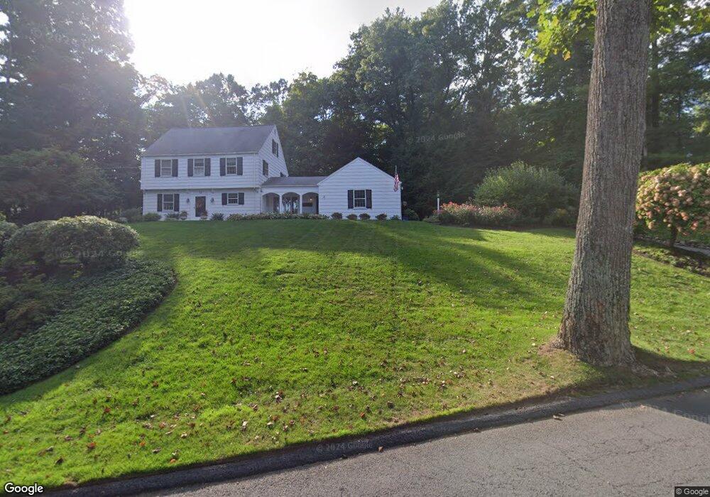
15 Cedar Ledge Rd West Hartford, CT 06107
Estimated Value: $869,000 - $1,014,000
5
Beds
4
Baths
3,788
Sq Ft
$244/Sq Ft
Est. Value
About This Home
This home is located at 15 Cedar Ledge Rd, West Hartford, CT 06107 and is currently estimated at $923,824, approximately $243 per square foot. 15 Cedar Ledge Rd is a home located in Hartford County with nearby schools including Braeburn School, Sedgwick Middle School, and Conard High School.
Ownership History
Date
Name
Owned For
Owner Type
Purchase Details
Closed on
Mar 6, 2021
Sold by
Alberghini Tod V
Bought by
Alberghini Tod V and Massucco Anne M
Current Estimated Value
Purchase Details
Closed on
Feb 21, 1992
Sold by
Cawley Deborah
Bought by
Alberghini Tod
Purchase Details
Closed on
Jan 29, 1988
Sold by
Sherrill C S
Bought by
Cawley M C
Create a Home Valuation Report for This Property
The Home Valuation Report is an in-depth analysis detailing your home's value as well as a comparison with similar homes in the area
Home Values in the Area
Average Home Value in this Area
Purchase History
| Date | Buyer | Sale Price | Title Company |
|---|---|---|---|
| Alberghini Tod V | -- | None Available | |
| Alberghini Tod | $370,000 | -- | |
| Cawley M C | $390,000 | -- |
Source: Public Records
Mortgage History
| Date | Status | Borrower | Loan Amount |
|---|---|---|---|
| Previous Owner | Cawley M C | $232,400 | |
| Previous Owner | Cawley M C | $427,500 | |
| Previous Owner | Cawley M C | $325,000 |
Source: Public Records
Tax History Compared to Growth
Tax History
| Year | Tax Paid | Tax Assessment Tax Assessment Total Assessment is a certain percentage of the fair market value that is determined by local assessors to be the total taxable value of land and additions on the property. | Land | Improvement |
|---|---|---|---|---|
| 2025 | $16,870 | $376,740 | $114,800 | $261,940 |
| 2024 | $15,955 | $376,740 | $114,800 | $261,940 |
| 2023 | $15,416 | $376,740 | $114,800 | $261,940 |
| 2022 | $15,326 | $376,740 | $114,800 | $261,940 |
| 2021 | $14,713 | $346,850 | $120,890 | $225,960 |
| 2020 | $14,674 | $351,050 | $118,720 | $232,330 |
| 2019 | $14,674 | $351,050 | $118,720 | $232,330 |
| 2018 | $14,393 | $351,050 | $118,720 | $232,330 |
| 2017 | $14,407 | $351,050 | $118,720 | $232,330 |
| 2016 | $14,257 | $360,850 | $118,580 | $242,270 |
| 2015 | $13,824 | $360,850 | $118,580 | $242,270 |
| 2014 | $13,485 | $360,850 | $118,580 | $242,270 |
Source: Public Records
Map
Nearby Homes
- 41 Soby Dr
- 170 Hunter Dr
- 186 Hunter Dr
- 37 W Normandy Dr
- 26 Berwyn Rd
- 269 Mountain Rd
- 16 Morningcrest Dr
- 15 Rushleigh Rd
- 56 Fox Chase Ln
- 21 Rushleigh Rd
- 124 High Ridge Rd
- 592 Mountain Rd Unit A
- 57 Wardwell Rd
- 51 Lemay St
- 132 N Main St
- 47 Flagg Rd
- 183 Loomis Dr Unit 109
- 2 Arapahoe Rd Unit 313
- 2 Arapahoe Rd Unit 308
- 2 Arapahoe Rd Unit 611
- 9 Cedar Ledge Rd
- 21 Cedar Ledge Rd
- 80 Hunter Dr
- 74 Hunter Dr
- 66 Hunter Dr
- 18 Cedar Ledge Rd
- 10 Cedar Ledge Rd
- 11 Uplands Dr
- 27 Cedar Ledge Rd
- 7 Uplands Dr
- 22 Cedar Ledge Rd
- 60 Hunter Dr
- 8 Cedar Ledge Rd
- 17 Uplands Dr
- 44 Hillsboro Dr
- 42 Hillsboro Dr
- 40 Hillsboro Dr
- 86 Hunter Dr
- 71 Hunter Dr
- 59 Hunter Dr