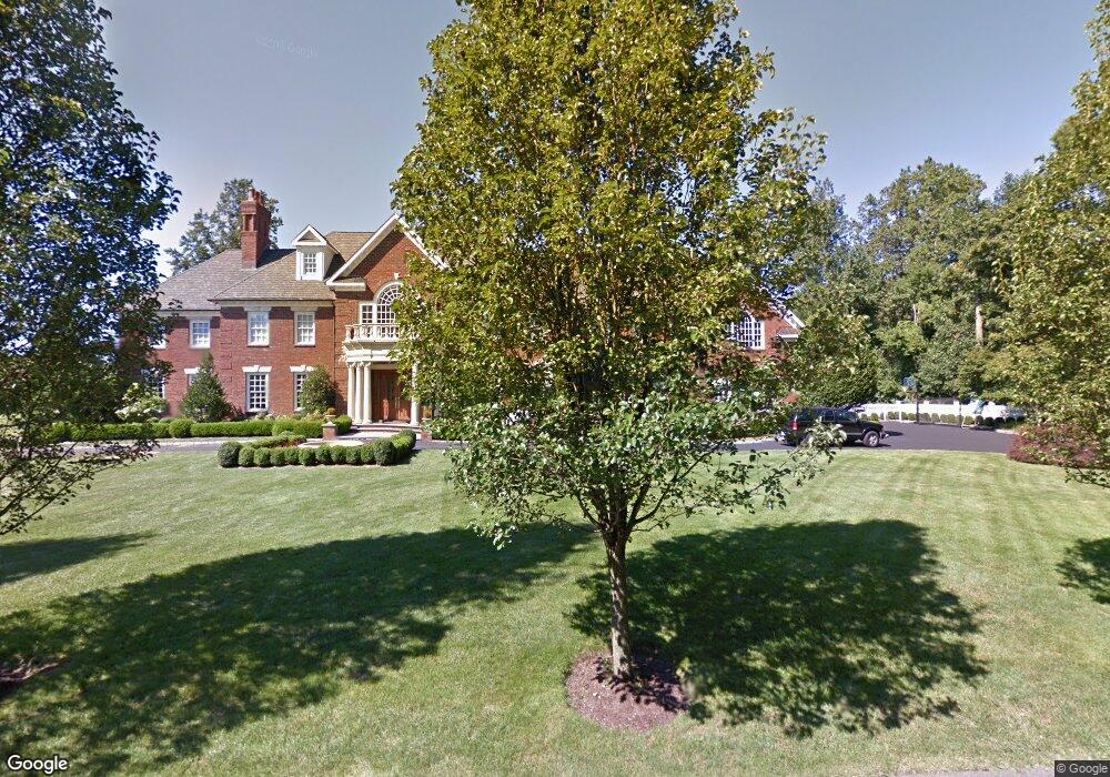
15 Daniel Ct Westport, CT 06880
Staples NeighborhoodEstimated Value: $4,107,645 - $5,819,000
4
Beds
7
Baths
8,757
Sq Ft
$534/Sq Ft
Est. Value
About This Home
This home is located at 15 Daniel Ct, Westport, CT 06880 and is currently estimated at $4,680,215, approximately $534 per square foot. 15 Daniel Ct is a home located in Fairfield County with nearby schools including Long Lots School, Bedford Middle School, and Staples High School.
Ownership History
Date
Name
Owned For
Owner Type
Purchase Details
Closed on
May 13, 2024
Sold by
Mattera Anna M and Mattera Walter J
Bought by
Mattera Anna M and Mattera Walter J
Current Estimated Value
Purchase Details
Closed on
Jun 30, 1997
Sold by
Contr Oly Mattera
Bought by
Mattera Anna and Mattera Walter
Create a Home Valuation Report for This Property
The Home Valuation Report is an in-depth analysis detailing your home's value as well as a comparison with similar homes in the area
Home Values in the Area
Average Home Value in this Area
Purchase History
| Date | Buyer | Sale Price | Title Company |
|---|---|---|---|
| Mattera Anna M | -- | None Available | |
| Mattera Anna M | -- | None Available | |
| Mattera Anna M | -- | None Available | |
| Mattera Anna | $300,000 | -- | |
| Mattera Anna | $300,000 | -- |
Source: Public Records
Tax History
| Year | Tax Paid | Tax Assessment Tax Assessment Total Assessment is a certain percentage of the fair market value that is determined by local assessors to be the total taxable value of land and additions on the property. | Land | Improvement |
|---|---|---|---|---|
| 2025 | $39,485 | $2,093,600 | $597,800 | $1,495,800 |
| 2024 | $38,983 | $2,093,600 | $597,800 | $1,495,800 |
| 2023 | $38,418 | $2,093,600 | $597,800 | $1,495,800 |
| 2022 | $37,831 | $2,093,600 | $597,800 | $1,495,800 |
| 2021 | $6,762 | $2,093,600 | $597,800 | $1,495,800 |
| 2020 | $6,661 | $2,345,800 | $594,600 | $1,751,200 |
| 2019 | $39,550 | $2,345,800 | $594,600 | $1,751,200 |
| 2018 | $4,764 | $2,345,800 | $594,600 | $1,751,200 |
| 2017 | $39,550 | $2,345,800 | $594,600 | $1,751,200 |
| 2016 | $39,550 | $2,345,800 | $594,600 | $1,751,200 |
| 2015 | $51,889 | $2,868,400 | $566,300 | $2,302,100 |
| 2014 | $51,459 | $2,868,400 | $566,300 | $2,302,100 |
Source: Public Records
Map
Nearby Homes
- 2177 Cross Hwy
- 110 Queens Grant Dr
- 21 Sturges Commons
- 6 Nutcracker Ln
- 13 Terhune Dr
- 1 Angora Rd
- 10 Debra Ln
- 44 Pumpkin Hill Rd
- 1 Sturges Hwy Unit 2
- 688 Hulls Farm Rd
- 10 Charcoal Hill Rd
- 1380 Old Academy Rd
- 212 Fence Row Dr
- 24 Warnock Dr
- 19 Joann Cir
- 88 Merry Meet Cir
- 16 Burr School Rd
- 21 Warnock Dr
- 14 Burr School Rd
- 3 Hunt Club Ln
Your Personal Tour Guide
Ask me questions while you tour the home.