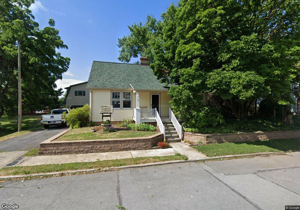
15 E Maple St Funkstown, MD 21734
Estimated Value: $258,000 - $278,000
Studio
--
Bath
1,610
Sq Ft
$165/Sq Ft
Est. Value
About This Home
This home is located at 15 E Maple St, Funkstown, MD 21734 and is currently estimated at $266,055, approximately $165 per square foot. 15 E Maple St is a home with nearby schools including Ruth Ann Monroe Primary School, Eastern Elementary School, and E. Russell Hicks Middle School.
Ownership History
Date
Name
Owned For
Owner Type
Purchase Details
Closed on
Jul 2, 1997
Sold by
Mills Mark J
Bought by
Parks Scott R
Current Estimated Value
Purchase Details
Closed on
Jul 13, 1983
Sold by
Langham Howard P
Bought by
Mills Mark J
Home Financials for this Owner
Home Financials are based on the most recent Mortgage that was taken out on this home.
Original Mortgage
$30,850
Interest Rate
13.3%
Create a Home Valuation Report for This Property
The Home Valuation Report is an in-depth analysis detailing your home's value as well as a comparison with similar homes in the area
Home Values in the Area
Average Home Value in this Area
Purchase History
| Date | Buyer | Sale Price | Title Company |
|---|---|---|---|
| Parks Scott R | $90,000 | -- | |
| Mills Mark J | $40,000 | -- |
Source: Public Records
Mortgage History
| Date | Status | Borrower | Loan Amount |
|---|---|---|---|
| Previous Owner | Mills Mark J | $30,850 | |
| Closed | Parks Scott R | -- |
Source: Public Records
Tax History
| Year | Tax Paid | Tax Assessment Tax Assessment Total Assessment is a certain percentage of the fair market value that is determined by local assessors to be the total taxable value of land and additions on the property. | Land | Improvement |
|---|---|---|---|---|
| 2025 | $1,487 | $209,800 | $0 | $0 |
| 2024 | $1,487 | $188,400 | $53,300 | $135,100 |
| 2023 | $1,408 | $171,767 | $0 | $0 |
| 2022 | $1,333 | $155,133 | $0 | $0 |
| 2021 | $1,289 | $138,500 | $53,300 | $85,200 |
| 2020 | $1,289 | $138,500 | $53,300 | $85,200 |
| 2019 | $1,295 | $138,500 | $53,300 | $85,200 |
| 2018 | $1,379 | $147,500 | $60,800 | $86,700 |
| 2017 | $1,369 | $146,400 | $0 | $0 |
| 2016 | -- | $145,300 | $0 | $0 |
| 2015 | -- | $144,200 | $0 | $0 |
| 2014 | $1,190 | $144,200 | $0 | $0 |
Source: Public Records
Map
Nearby Homes
- 414 Beaver Creek Rd
- 1432 Oak Ridge Place
- 11 Funkstown Rd
- 12.3 AC Southern Blvd
- 2 Charlotte St
- 90 Charlotte St
- 605 Knightsbridge Dr
- 628 Knightsbridge Dr
- 103 Charlotte St
- 104 Charlotte St
- 202 S Fork Dr
- 104 S Edgewood Dr Unit 104
- 0 Kenly Ave
- 1619 Dual Hwy
- 920 Frederick St
- 925 Frederick St
- 329 Emmert Rd
- 1747 Edgewood Hill Cir Unit 201
- 124 Buttercup Dr
- Lot 7-16 Lawton Ln
Your Personal Tour Guide
Ask me questions while you tour the home.