Estimated Value: $306,000 - $319,214
--
Bed
--
Bath
2,456
Sq Ft
$128/Sq Ft
Est. Value
About This Home
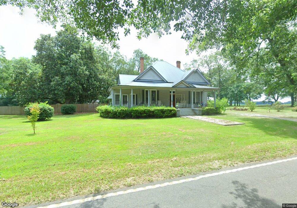
This home is located at 15 Ga Highway 127 W, Mauk, GA 31058 and is currently estimated at $314,804, approximately $128 per square foot. 15 Ga Highway 127 W is a home with nearby schools including Taylor County Primary School, Taylor County Upper Elementary School, and Taylor County Middle School.
Ownership History
Date
Name
Owned For
Owner Type
Purchase Details
Closed on
Oct 23, 2018
Sold by
Kelso John
Bought by
Kelso John and Kelso Rhiannon Marie
Current Estimated Value
Home Financials for this Owner
Home Financials are based on the most recent Mortgage that was taken out on this home.
Original Mortgage
$97,206
Outstanding Balance
$84,950
Interest Rate
4.6%
Mortgage Type
FHA
Estimated Equity
$229,854
Purchase Details
Closed on
Oct 12, 2018
Sold by
Lawhorn Terry Louise
Bought by
Kelso John
Home Financials for this Owner
Home Financials are based on the most recent Mortgage that was taken out on this home.
Original Mortgage
$97,206
Outstanding Balance
$84,950
Interest Rate
4.6%
Mortgage Type
FHA
Estimated Equity
$229,854
Purchase Details
Closed on
Nov 1, 2012
Sold by
Wall Martha Louise
Bought by
Lawhorn Terry Louise and Stewart Telynn Mary
Purchase Details
Closed on
Apr 29, 2009
Sold by
Wall Ulus G
Bought by
Wall Mary Louise
Create a Home Valuation Report for This Property
The Home Valuation Report is an in-depth analysis detailing your home's value as well as a comparison with similar homes in the area
Home Values in the Area
Average Home Value in this Area
Purchase History
| Date | Buyer | Sale Price | Title Company |
|---|---|---|---|
| Kelso John | -- | -- | |
| Kelso John | $99,000 | -- | |
| Lawhorn Terry Louise | -- | -- | |
| Wall Mary Louise | -- | -- |
Source: Public Records
Mortgage History
| Date | Status | Borrower | Loan Amount |
|---|---|---|---|
| Open | Kelso John | $97,206 |
Source: Public Records
Tax History Compared to Growth
Tax History
| Year | Tax Paid | Tax Assessment Tax Assessment Total Assessment is a certain percentage of the fair market value that is determined by local assessors to be the total taxable value of land and additions on the property. | Land | Improvement |
|---|---|---|---|---|
| 2024 | $820 | $69,640 | $2,040 | $67,600 |
| 2023 | $1,240 | $55,360 | $1,760 | $53,600 |
| 2022 | $1,208 | $52,600 | $1,760 | $50,840 |
| 2021 | $1,161 | $49,360 | $1,480 | $47,880 |
| 2020 | $1,171 | $49,360 | $1,480 | $47,880 |
| 2019 | $955 | $49,360 | $1,480 | $47,880 |
| 2018 | $1,271 | $52,800 | $1,480 | $51,320 |
| 2017 | $1,155 | $48,534 | $1,800 | $46,734 |
| 2016 | $1,163 | $48,534 | $1,800 | $46,734 |
| 2015 | -- | $48,534 | $1,800 | $46,734 |
| 2014 | -- | $41,892 | $2,000 | $39,892 |
| 2013 | -- | $43,381 | $2,000 | $41,381 |
Source: Public Records
Map
Nearby Homes
- 0 Miller Rd Unit 10319190
- 0 Miller Rd Unit 25510377
- 0 Miller Rd Unit 25510378
- 0 Moores Chapel Rd Unit 10650485
- 0 Moores Chapel Rd Unit 25800784
- 0 Moores Chapel Rd Unit 25510371
- 0 Moores Chapel Rd Unit 2 10582259
- 0 Moores Chapel Rd Unit 10544008
- 0 Moores Chapel Rd Unit 1 10582252
- Moores Chapel Rd
- 15 Georgia 127
- 0 Montgomery Rd
- 375 Village Ln
- 322 Moores Chapel Rd
- 0 Poll Mill Rd
- 2450 Fort Perry Rd
- 65 Saddle Trail
- 0 Brannon Montgomery Rd Unit 10453495
- 0 Brannon Montgomery Rd Unit 25510431
- 766 Parks Rd
- 2472 Ga Highway 90 W
- 2472 Ga Highway 90 W
- 2057 Ga Highway 90 W
- 46 Will Turner Rd
- 2273 Ga Highway 90 W
- 398 Mount Zion Church Rd
- 1459 Henry Currington Rd
- 45 Will Turner Rd
- 99 Mount Zion Church Rd
- 101 Will Turner Rd
- 15 Simmons Rd
- 2203 Ga Highway 90 W
- 2243 Ga Highway 90 W
- 2240 W Ga Hwy 0090
- 2235 Ga Highway 90 W
- 119 Will Turner Rd
- 481 Sand Pit Rd
- 493 Sandpit Rd
- 267 New Zion Rd
- 2536 Ga Highway 90 W