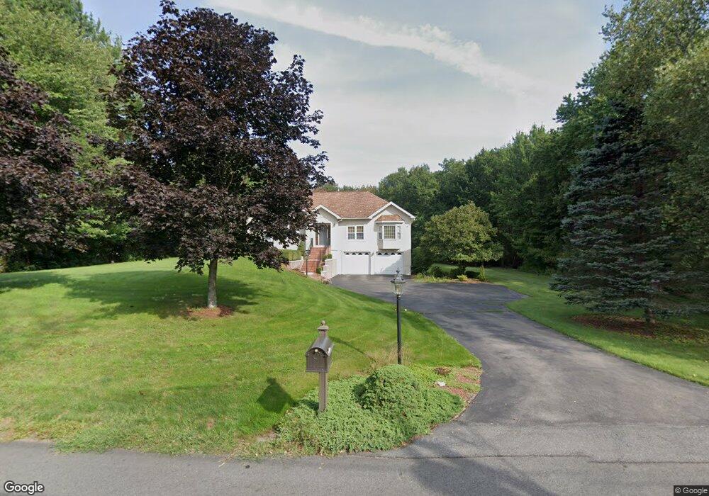
15 Handy Rd Blackstone, MA 01504
Estimated Value: $549,000 - $655,049
3
Beds
2
Baths
1,676
Sq Ft
$347/Sq Ft
Est. Value
About This Home
This home is located at 15 Handy Rd, Blackstone, MA 01504 and is currently estimated at $581,012, approximately $346 per square foot. 15 Handy Rd is a home located in Worcester County with nearby schools including Blackstone-Millville Regional High School, Founders Academy, and Beacon Charter School.
Ownership History
Date
Name
Owned For
Owner Type
Purchase Details
Closed on
Jan 8, 1999
Sold by
Thayer Rt and Hadley Diane
Bought by
Vadenboncoer
Current Estimated Value
Purchase Details
Closed on
Aug 14, 1997
Sold by
Phoenix Realty Holding
Bought by
Thayer Rt and Hadley Diane
Create a Home Valuation Report for This Property
The Home Valuation Report is an in-depth analysis detailing your home's value as well as a comparison with similar homes in the area
Home Values in the Area
Average Home Value in this Area
Purchase History
| Date | Buyer | Sale Price | Title Company |
|---|---|---|---|
| Vadenboncoer | $65,000 | -- | |
| Thayer Rt | $5,000 | -- |
Source: Public Records
Mortgage History
| Date | Status | Borrower | Loan Amount |
|---|---|---|---|
| Open | Thayer Rt | $185,000 | |
| Closed | Thayer Rt | $176,000 | |
| Closed | Thayer Rt | $220,000 |
Source: Public Records
Tax History Compared to Growth
Tax History
| Year | Tax Paid | Tax Assessment Tax Assessment Total Assessment is a certain percentage of the fair market value that is determined by local assessors to be the total taxable value of land and additions on the property. | Land | Improvement |
|---|---|---|---|---|
| 2025 | $9,324 | $617,500 | $206,700 | $410,800 |
| 2024 | $9,187 | $562,600 | $225,100 | $337,500 |
| 2023 | $9,014 | $557,100 | $225,100 | $332,000 |
| 2022 | $8,868 | $495,400 | $177,800 | $317,600 |
| 2021 | $7,217 | $385,500 | $177,800 | $207,700 |
| 2020 | $7,616 | $403,800 | $179,800 | $224,000 |
| 2019 | $7,568 | $400,200 | $169,600 | $230,600 |
| 2018 | $8,575 | $386,600 | $166,400 | $220,200 |
| 2017 | $8,308 | $370,800 | $172,200 | $198,600 |
| 2016 | $6,446 | $333,300 | $145,000 | $188,300 |
| 2015 | $6,376 | $327,300 | $136,900 | $190,400 |
Source: Public Records
Map
Nearby Homes
- 25 Milk St
- 227 Blackstone St
- 1, 3, 5 Old Lincoln St
- 160 Federal St
- 9 Spruce St
- 10 Autumn Ln
- 162 Blackstone St
- 244 Mendon St
- 183-183R Mendon St
- 17 Colonial Dr
- Lot 3 Pickering Rd
- Lot 1 Pickering Rd
- Lot 4 Pickering Rd
- 40 Union St
- 15 Fox Run Rd Unit 15
- 62 Laurel Ln
- 5 Monica Ln
- 44 Federal St
- 19 King Philip Path
- 361 S Main St