Estimated Value: $233,000 - $302,000
3
Beds
2
Baths
1,512
Sq Ft
$170/Sq Ft
Est. Value
About This Home
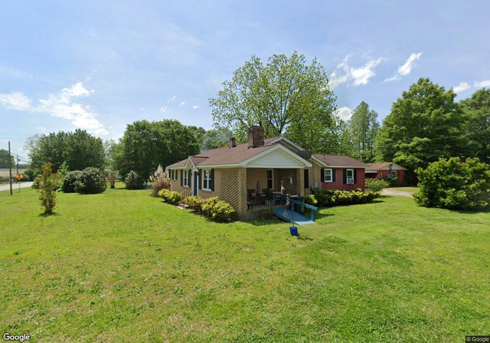
This home is located at 15 Holly Ave, Comer, GA 30629 and is currently estimated at $257,599, approximately $170 per square foot. 15 Holly Ave is a home located in Madison County with nearby schools including Madison County High School.
Ownership History
Date
Name
Owned For
Owner Type
Purchase Details
Closed on
Apr 24, 2021
Sold by
Baxley Belinda Taylor
Bought by
Duhon Rebecca
Current Estimated Value
Purchase Details
Closed on
Jun 2, 2008
Sold by
Brown Debra
Bought by
Baxley Malvin
Home Financials for this Owner
Home Financials are based on the most recent Mortgage that was taken out on this home.
Original Mortgage
$89,600
Interest Rate
6.02%
Mortgage Type
New Conventional
Purchase Details
Closed on
May 24, 2007
Sold by
Bullock Lonnie Merle Scarb
Bought by
Brown Derba Aa
Purchase Details
Closed on
Jan 1, 1959
Bought by
Bullock Lonnie Merle
Create a Home Valuation Report for This Property
The Home Valuation Report is an in-depth analysis detailing your home's value as well as a comparison with similar homes in the area
Home Values in the Area
Average Home Value in this Area
Purchase History
| Date | Buyer | Sale Price | Title Company |
|---|---|---|---|
| Duhon Rebecca | $112,000 | -- | |
| Baxley Malvin | $112,000 | -- | |
| Brown Derba Aa | $111,000 | -- | |
| Bullock Lonnie Merle | -- | -- |
Source: Public Records
Mortgage History
| Date | Status | Borrower | Loan Amount |
|---|---|---|---|
| Previous Owner | Baxley Malvin | $89,600 |
Source: Public Records
Tax History Compared to Growth
Tax History
| Year | Tax Paid | Tax Assessment Tax Assessment Total Assessment is a certain percentage of the fair market value that is determined by local assessors to be the total taxable value of land and additions on the property. | Land | Improvement |
|---|---|---|---|---|
| 2024 | $2,470 | $79,238 | $15,926 | $63,312 |
| 2023 | $2,260 | $72,486 | $13,272 | $59,214 |
| 2022 | $1,964 | $61,384 | $9,127 | $52,257 |
| 2021 | $1,331 | $45,758 | $9,127 | $36,631 |
| 2020 | $1,111 | $44,431 | $7,800 | $36,631 |
| 2019 | $1,099 | $43,658 | $7,800 | $35,858 |
| 2018 | $1,048 | $41,999 | $7,136 | $34,863 |
| 2017 | $1,326 | $38,574 | $6,636 | $31,938 |
| 2016 | $702 | $33,310 | $6,033 | $27,277 |
| 2015 | $699 | $33,310 | $6,033 | $27,277 |
| 2014 | $791 | $36,406 | $9,048 | $27,358 |
| 2013 | -- | $36,406 | $9,048 | $27,358 |
Source: Public Records
Map
Nearby Homes
- 12 Laurel Ave
- 3 Paoli St
- 470 Gholston St
- 40 Kingston Dr
- Trct 1 Paoli St
- 2649 Paoli St
- 135 Shannons Place
- 540 Sunset Ave
- 0 Live Oak Ln Unit lot 3
- 0 Live Oak Ln Unit lot 12
- 0 Live Oak Ln Unit lot 5
- 858 Clairmont Ave
- 0 Lowe Rd Unit 10614126
- 5866 Highway 98 E
- 2975 Georgia 72
- 15 Shady Oaks Ln
- 0 Paoli Rd Unit 23882833
- 0 Poss Rd Unit 11540856
- 305 Gholston St
- TRACT #2 Holly Ave
- 0 Holly Ave
- 304 Gholston St
- 317 Gholston St
- 46 Holly Ave
- 243 Gholston St
- 272 Gholston St
- 2110 College St
- 54 Laurel Ave
- 226 Gholston St
- 2 Laurel Ave
- 0 W Pine Ave
- 0 W Pine Ave Unit CM380922
- 0 W Pine Ave Unit 983043
- 0 W Pine Ave Unit 7238511
- 0 W Pine Ave Unit 7341053
- 0 W Pine Ave Unit 8356106
- 0 W Pine Ave Unit 7104714
- 0 W Pine Ave Unit 9030112