


15 Hudson Ave Chicopee, MA 01020
Fairview NeighborhoodHighlights
- Medical Services
- Property is near public transit and schools
- Porch
- Colonial Architecture
- No HOA
- Shops
About This Home
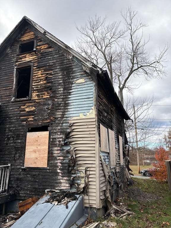
FIRE DAMAGED HOME. SOLD “AS IS, WHERE IS”. NO INTERIOR ACCESS.CASH SALE ONLY All contents of the home, shed and yard to remain and are the buyer's responsibility to remove.
Home Details
Home Type
- Single Family
Year Built
- Built in 1880
Home Design
- Colonial Architecture
- Frame Construction
- Shingle Roof
- Concrete Perimeter Foundation
Interior Spaces
- 1,119 Sq Ft Home
- Basement Fills Entire Space Under The House
Bedrooms and Bathrooms
- 3 Bedrooms
- 1 Full Bathroom
Parking
- 3 Car Parking Spaces
- Driveway
- 3 Open Parking Spaces
- Off-Street Parking
Utilities
- No Cooling
- Hot Water Heating System
Additional Features
- Porch
- 5,138 Sq Ft Lot
- Property is near public transit and schools
Listing and Financial Details
- Assessor Parcel Number 2512726
Community Details
Overview
- No Home Owners Association
Amenities
- Medical Services
- Shops
Map
Home Values in the Area
Average Home Value in this Area
Tax History
| Year | Tax Paid | Tax Assessment Tax Assessment Total Assessment is a certain percentage of the fair market value that is determined by local assessors to be the total taxable value of land and additions on the property. | Land | Improvement |
|---|---|---|---|---|
| 2025 | $3,312 | $218,500 | $84,800 | $133,700 |
| 2024 | $3,141 | $212,800 | $83,100 | $129,700 |
| 2023 | $2,944 | $194,300 | $75,600 | $118,700 |
| 2022 | $2,808 | $165,300 | $65,700 | $99,600 |
| 2021 | $2,647 | $150,300 | $59,700 | $90,600 |
| 2020 | $2,547 | $145,900 | $61,300 | $84,600 |
| 2019 | $2,513 | $139,900 | $61,300 | $78,600 |
| 2018 | $2,413 | $131,800 | $58,400 | $73,400 |
| 2017 | $2,392 | $138,200 | $58,100 | $80,100 |
| 2016 | $2,286 | $135,200 | $58,100 | $77,100 |
| 2015 | $2,412 | $137,500 | $58,100 | $79,400 |
| 2014 | $1,206 | $137,500 | $58,100 | $79,400 |
Property History
| Date | Event | Price | List to Sale | Price per Sq Ft |
|---|---|---|---|---|
| 12/29/2025 12/29/25 | Pending | -- | -- | -- |
| 12/20/2025 12/20/25 | For Sale | $125,000 | 0.0% | $112 / Sq Ft |
| 12/16/2025 12/16/25 | Off Market | $125,000 | -- | -- |
| 12/03/2025 12/03/25 | For Sale | $125,000 | -- | $112 / Sq Ft |
Purchase History
| Date | Type | Sale Price | Title Company |
|---|---|---|---|
| Deed | $85,000 | -- |
Mortgage History
| Date | Status | Loan Amount | Loan Type |
|---|---|---|---|
| Open | $50,000 | No Value Available | |
| Closed | $8,600 | No Value Available |
Source: MLS Property Information Network (MLS PIN)
MLS Number: 73459290
APN: CHIC-000724-000000-000029
Disclaimer: Certain information contained herein is derived from information provided by parties other than Homes.com. All information provided is deemed reliable, but is not guaranteed to be accurate and should be independently verified.
![]() The property listing data and information, or the Images, set forth herein were provided to MLS Property Information Network, Inc. from third party sources, including sellers, lessors and public records, and were compiled by MLS Property Information Network, Inc. The property listing data and information, and the Images, are for the personal, non-commercial use of consumers having a good faith interest in purchasing or leasing listed properties of the type displayed to them and may not be used for any purpose other than to identify prospective properties which such consumers may have a good faith interest in purchasing or leasing. MLS Property Information Network, Inc. and its subscribers disclaim any and all representations and warranties as to the accuracy of the property listing data and information, or as to the accuracy of any of the Images, set forth herein.
The property listing data and information, or the Images, set forth herein were provided to MLS Property Information Network, Inc. from third party sources, including sellers, lessors and public records, and were compiled by MLS Property Information Network, Inc. The property listing data and information, and the Images, are for the personal, non-commercial use of consumers having a good faith interest in purchasing or leasing listed properties of the type displayed to them and may not be used for any purpose other than to identify prospective properties which such consumers may have a good faith interest in purchasing or leasing. MLS Property Information Network, Inc. and its subscribers disclaim any and all representations and warranties as to the accuracy of the property listing data and information, or as to the accuracy of any of the Images, set forth herein.
- 18 Devlin Dr
- 61 Saint Jacques Ave
- 143 Royal St
- 1709 Memorial Dr
- 128 Ann St
- 523 James St
- 41 Susan Ave
- 81 Mccarthy Ave
- 84 Montcalm St
- 90 Anson St
- 35 Ludlow Rd
- 83 Old Farm Rd
- 67 Streiber Dr
- 442 Prospect St
- 104 Johnson Rd Unit 1103
- 104 Johnson Rd Unit 707
- 460 Irene St
- 25 Shadow Brook Estates Unit 25
- 56 Old Lyman Rd
- 144 Horseshoe Dr

Ask me questions while you tour the home.