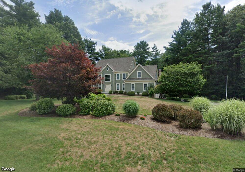
15 Laurel Ln Canton, MA 02021
Estimated Value: $1,256,291 - $1,525,000
4
Beds
3
Baths
3,226
Sq Ft
$427/Sq Ft
Est. Value
About This Home
This home is located at 15 Laurel Ln, Canton, MA 02021 and is currently estimated at $1,376,573, approximately $426 per square foot. 15 Laurel Ln is a home located in Norfolk County with nearby schools including Canton High School.
Ownership History
Date
Name
Owned For
Owner Type
Purchase Details
Closed on
Aug 25, 2020
Sold by
Sullivan Charles V and Sullivan Linda
Bought by
C V Sullivan 2017 Ret
Current Estimated Value
Purchase Details
Closed on
Sep 5, 2008
Sold by
Dibner Hart K and Dibner Trudy E
Bought by
Sullivan Charles and Sullivan Linda
Purchase Details
Closed on
Jan 14, 2000
Sold by
Dukeshire Curt C and Dukeshire Maria
Bought by
Dibner Hart K and Dibner Trudy E
Home Financials for this Owner
Home Financials are based on the most recent Mortgage that was taken out on this home.
Original Mortgage
$240,000
Interest Rate
7.98%
Purchase Details
Closed on
Aug 14, 1998
Sold by
Gibson James R and Gibson Pamela J
Bought by
Dukeshire Curt C and Dukeshire Maria
Create a Home Valuation Report for This Property
The Home Valuation Report is an in-depth analysis detailing your home's value as well as a comparison with similar homes in the area
Home Values in the Area
Average Home Value in this Area
Purchase History
| Date | Buyer | Sale Price | Title Company |
|---|---|---|---|
| C V Sullivan 2017 Ret | -- | None Available | |
| Sullivan Charles | $817,500 | -- | |
| Dibner Hart K | $515,000 | -- | |
| Dukeshire Curt C | $450,000 | -- |
Source: Public Records
Mortgage History
| Date | Status | Borrower | Loan Amount |
|---|---|---|---|
| Previous Owner | Dukeshire Curt C | $240,000 | |
| Previous Owner | Dukeshire Curt C | $463,500 |
Source: Public Records
Tax History
| Year | Tax Paid | Tax Assessment Tax Assessment Total Assessment is a certain percentage of the fair market value that is determined by local assessors to be the total taxable value of land and additions on the property. | Land | Improvement |
|---|---|---|---|---|
| 2025 | $10,950 | $1,107,200 | $386,800 | $720,400 |
| 2024 | $10,706 | $1,073,800 | $372,000 | $701,800 |
| 2023 | $10,231 | $967,900 | $372,000 | $595,900 |
| 2022 | $10,175 | $896,500 | $354,300 | $542,200 |
| 2021 | $9,969 | $817,100 | $321,800 | $495,300 |
| 2020 | $9,522 | $778,600 | $306,600 | $472,000 |
| 2019 | $9,481 | $764,600 | $278,700 | $485,900 |
| 2018 | $9,490 | $764,100 | $290,900 | $473,200 |
| 2017 | $9,658 | $755,100 | $285,200 | $469,900 |
| 2016 | $9,498 | $742,600 | $278,200 | $464,400 |
| 2015 | $9,261 | $722,400 | $270,100 | $452,300 |
Source: Public Records
Map
Nearby Homes
- 140 York St
- 79 Gold St
- 50 Indian Ln
- 106 Indian Ln
- 1831 Turnpike St
- 902 Irving Rd Unit 902
- 232 Canton St Unit 308
- 232 Canton St Unit 104
- 195 High St
- 555 Page St Unit 105
- 43 Emily Jeffers Rd
- 888 Turnpike St
- 10 Michael Rd
- 17 Mazzeo Dr
- Lot 43 Pondview Ln
- Lot 2 Pondview Ln
- 4 Franklin Square Unit 4F
- 51 Himoor Cir
- 25 Edward St
- 153 West St
Your Personal Tour Guide
Ask me questions while you tour the home.