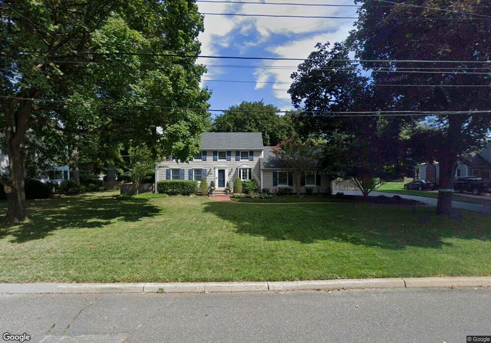
15 Laurelwood Dr Little Silver, NJ 07739
Estimated Value: $1,008,000 - $1,153,000
4
Beds
2
Baths
1,840
Sq Ft
$588/Sq Ft
Est. Value
About This Home
This home is located at 15 Laurelwood Dr, Little Silver, NJ 07739 and is currently estimated at $1,082,541, approximately $588 per square foot. 15 Laurelwood Dr is a home located in Monmouth County with nearby schools including Point Road School, Markham Place School, and Red Bank Regional High School.
Ownership History
Date
Name
Owned For
Owner Type
Purchase Details
Closed on
Dec 21, 1993
Sold by
Burno Anthony
Bought by
Bollinger John and Bollinger Lisa
Current Estimated Value
Home Financials for this Owner
Home Financials are based on the most recent Mortgage that was taken out on this home.
Original Mortgage
$245,000
Interest Rate
7.03%
Create a Home Valuation Report for This Property
The Home Valuation Report is an in-depth analysis detailing your home's value as well as a comparison with similar homes in the area
Home Values in the Area
Average Home Value in this Area
Purchase History
| Date | Buyer | Sale Price | Title Company |
|---|---|---|---|
| Bollinger John | $272,000 | -- |
Source: Public Records
Mortgage History
| Date | Status | Borrower | Loan Amount |
|---|---|---|---|
| Closed | Bollinger John | $245,000 |
Source: Public Records
Tax History Compared to Growth
Tax History
| Year | Tax Paid | Tax Assessment Tax Assessment Total Assessment is a certain percentage of the fair market value that is determined by local assessors to be the total taxable value of land and additions on the property. | Land | Improvement |
|---|---|---|---|---|
| 2025 | $14,574 | $1,055,800 | $739,700 | $316,100 |
| 2024 | $13,613 | $863,400 | $558,000 | $305,400 |
| 2023 | $13,613 | $756,300 | $458,000 | $298,300 |
| 2022 | $12,053 | $642,000 | $358,000 | $284,000 |
| 2021 | $12,053 | $610,600 | $358,000 | $252,600 |
| 2020 | $12,261 | $604,900 | $358,000 | $246,900 |
| 2019 | $11,944 | $600,200 | $358,000 | $242,200 |
| 2018 | $11,768 | $589,000 | $358,000 | $231,000 |
| 2017 | $11,685 | $581,900 | $358,000 | $223,900 |
| 2016 | $11,434 | $576,300 | $358,000 | $218,300 |
| 2015 | $11,335 | $564,200 | $328,000 | $236,200 |
| 2014 | $11,410 | $530,700 | $328,000 | $202,700 |
Source: Public Records
Map
Nearby Homes
- 87 Rumson Rd
- 55 Cheshire Square
- 172 Woods End Dr
- 30 Crest Dr
- 32 Woodbine Ave
- 26 Prince Place
- 33 Willow Dr
- 50 Willow Dr
- 199 Pinckney Rd
- 420 Rumson Rd
- 82 Little Silver Pkwy
- 82 Ridge Rd
- 492 Hance Rd
- 69 Harvard Rd
- 135 Harrison Ave
- 132 Harrison Ave
- 40 Brookside Ln
- 1 George St
- 91 Forrest Ave
- 85 Tower Hill Dr Unit 608
- 11 Laurelwood Dr
- 19 Laurelwood Dr
- 14 Laurelwood Dr
- 18 Laurelwood Dr
- 25 Laurelwood Dr
- 8 Laurelwood Dr
- 24 Laurelwood Dr
- 179 Rumson Rd
- 167 Rumson Rd
- 189 Rumson Rd
- 163 Rumson Rd
- 175 Rumson Rd
- 29 Laurelwood Dr
- 389 Prospect Ave
- 395 Prospect Ave
- 157 Rumson Rd
- 401 Prospect Ave
- 193 Rumson Rd
- 385 Prospect Ave
- 381 Prospect Ave