15 Mansfield St Unit 2 Allston, MA 02134
Allston NeighborhoodEstimated Value: $1,414,000 - $1,806,173
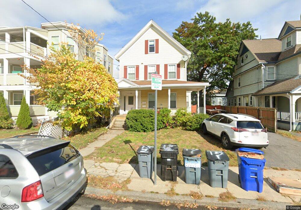
About This Home
Welcome to 15 Mansfield St #2, a spacious and convenient residence offering comfortable living in a highly sought-after location. This beautifully maintained unit boasts four bedrooms and two bathrooms.
As you step inside, you'll immediately notice the thoughtfully designed layout and well-appointed features. The open living area provides a warm and inviting atmosphere, perfect for entertaining guests or simply relaxing after a long day. The unit is equipped with modern in-unit laundry facilities, allowing for the utmost convenience and eliminating the need to visit a laundromat.
One of the standout features of this property is the private deck, providing a serene outdoor space where you can unwind, enjoy a morning coffee, or host summer gatherings with friends and loved ones. It offers a retreat from the bustling city, allowing you to soak in the fresh air and enjoy some downtime.
Furthermore, off-street parking is available, making it convenient for residents to come and go without the hassle of searching for parking spaces. This sought-after amenity ensures that your vehicle is secure and easily accessible whenever you need it.
The location of 15 Mansfield St #2 is truly unbeatable. Situated in close proximity to Harvard Business School and Boston Landing, you'll have easy access to world-class educational institutions, renowned employers, and vibrant business centers.
Don't miss the opportunity to make this remarkable residence your own. Schedule a viewing today and experience the comfort, convenience, and charm that 15 Mansfield St #2 has to offer.
* Prices and availability subject to change without notice. Square footage definitions vary. Displayed square footage may be approximate. Round Room is not liable for any errors, omissions, or changes to terms and conditions of this rental.
Ownership History
Purchase Details
Purchase Details
Home Financials for this Owner
Home Financials are based on the most recent Mortgage that was taken out on this home.Purchase Details
Purchase Details
Home Values in the Area
Average Home Value in this Area
Purchase History
| Date | Buyer | Sale Price | Title Company |
|---|---|---|---|
| Quintic Llc | -- | -- | |
| Lian Bong | $1,150,000 | -- | |
| Juvalles Paul J | -- | -- | |
| John A Juvalles Ret | -- | -- |
Mortgage History
| Date | Status | Borrower | Loan Amount |
|---|---|---|---|
| Previous Owner | Lian Bong | $747,500 |
Property History
| Date | Event | Price | List to Sale | Price per Sq Ft |
|---|---|---|---|---|
| 07/19/2025 07/19/25 | Off Market | $4,200 | -- | -- |
| 06/11/2025 06/11/25 | For Rent | $4,200 | -- | -- |
Tax History Compared to Growth
Tax History
| Year | Tax Paid | Tax Assessment Tax Assessment Total Assessment is a certain percentage of the fair market value that is determined by local assessors to be the total taxable value of land and additions on the property. | Land | Improvement |
|---|---|---|---|---|
| 2025 | $16,391 | $1,415,500 | $522,500 | $893,000 |
| 2024 | $13,406 | $1,229,900 | $305,600 | $924,300 |
| 2023 | $12,457 | $1,159,900 | $288,200 | $871,700 |
| 2022 | $11,905 | $1,094,200 | $271,900 | $822,300 |
| 2021 | $11,675 | $1,094,200 | $271,900 | $822,300 |
| 2020 | $10,358 | $980,900 | $251,900 | $729,000 |
| 2019 | $9,006 | $854,500 | $189,800 | $664,700 |
| 2018 | $8,291 | $791,100 | $189,800 | $601,300 |
| 2017 | $8,214 | $775,600 | $189,800 | $585,800 |
| 2016 | $7,420 | $674,500 | $189,800 | $484,700 |
| 2015 | $6,803 | $561,735 | $174,040 | $387,695 |
| 2014 | $6,009 | $477,700 | $179,200 | $298,500 |
Map
- 27 Coolidge Rd Unit 1
- 1 Highgate St
- 8 Franklin St Unit 202
- 8 Franklin St Unit 401
- 4 Franklin St Unit 403
- 106 Chester St Unit 3
- 195 Cambridge St Unit 3
- 97 Chester St Unit 8
- 35 Adamson St
- 42 Hopedale St
- 20 Penniman Rd Unit P3
- 20 Penniman Rd Unit 208
- 59 Brighton Ave Unit 1
- 57 Brighton Ave Unit C
- 57 Brighton Ave Unit B
- 30 Penniman Rd Unit 201
- 54-60 Holton St Unit 58
- 231 Everett St Unit 1
- 21 Park Vale Ave Unit 2
- 15 N Beacon St Unit 328
- 15 Mansfield St
- 17 Mansfield St
- 17 Mansfield St Unit 2
- 17 Mansfield St Unit 3
- 17 Mansfield St Unit 1
- 13 Mansfield St Unit 4
- 11 Mansfield St Unit 13
- 11 Mansfield St Unit 13
- 11 Mansfield St Unit 13
- 11 Mansfield St Unit 13
- 11 Mansfield St Unit 2
- 13 Mansfield St
- 13 Mansfield St Unit 1R
- 11 Mansfield St Unit 9 1
- 11-13 Mansfield St Unit 2
- 11 Mansfield St Unit 4
- 11 Mansfield St Unit 9 4
- 11 Mansfield St
- 13 Mansfield St Unit 7
- 11-13 Mansfield St