Estimated Value: $749,416 - $800,000
4
Beds
2
Baths
1,712
Sq Ft
$458/Sq Ft
Est. Value
About This Home
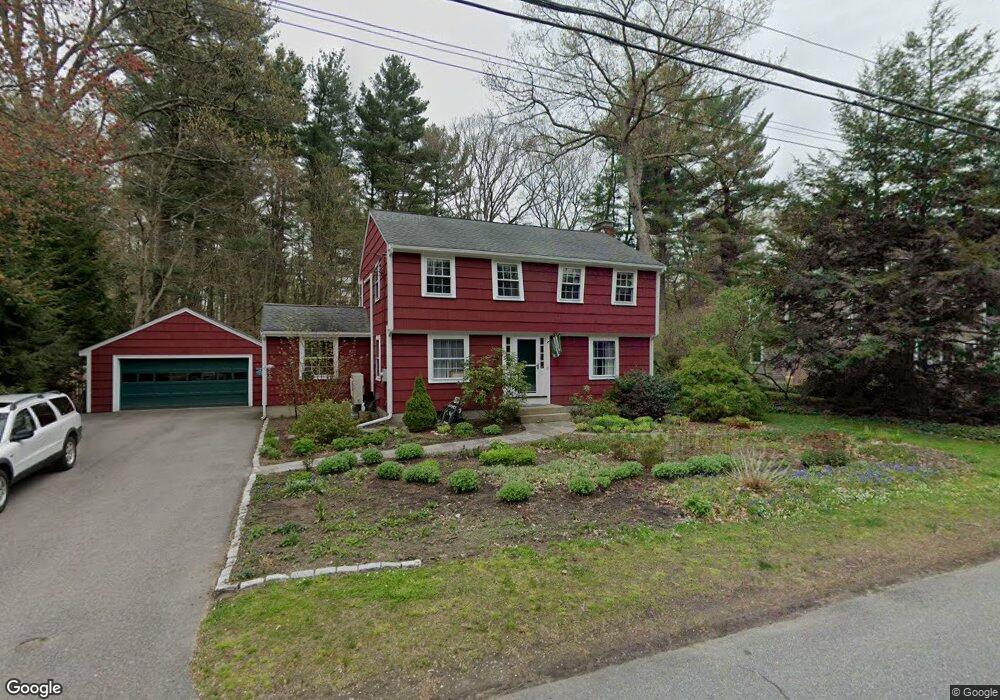
This home is located at 15 Mohegan Rd, Acton, MA 01720 and is currently estimated at $784,354, approximately $458 per square foot. 15 Mohegan Rd is a home located in Middlesex County with nearby schools including Acton-Boxborough Regional High School.
Ownership History
Date
Name
Owned For
Owner Type
Purchase Details
Closed on
Jan 27, 2021
Sold by
Trostorff Astrid C and Berliner Harvey P
Bought by
Berliner & Trostorff Ft
Current Estimated Value
Purchase Details
Closed on
Aug 21, 1985
Bought by
Trostorff Astrid C
Create a Home Valuation Report for This Property
The Home Valuation Report is an in-depth analysis detailing your home's value as well as a comparison with similar homes in the area
Home Values in the Area
Average Home Value in this Area
Purchase History
| Date | Buyer | Sale Price | Title Company |
|---|---|---|---|
| Berliner & Trostorff Ft | -- | None Available | |
| Trostorff Astrid C | -- | -- |
Source: Public Records
Mortgage History
| Date | Status | Borrower | Loan Amount |
|---|---|---|---|
| Previous Owner | Trostorff Astrid C | $150,000 | |
| Previous Owner | Trostorff Astrid C | $73,700 | |
| Previous Owner | Trostorff Astrid C | $130,000 |
Source: Public Records
Tax History
| Year | Tax Paid | Tax Assessment Tax Assessment Total Assessment is a certain percentage of the fair market value that is determined by local assessors to be the total taxable value of land and additions on the property. | Land | Improvement |
|---|---|---|---|---|
| 2025 | $11,220 | $654,200 | $312,500 | $341,700 |
| 2024 | $10,545 | $632,600 | $312,500 | $320,100 |
| 2023 | $10,259 | $584,200 | $284,100 | $300,100 |
| 2022 | $9,731 | $500,300 | $246,800 | $253,500 |
| 2021 | $9,480 | $468,600 | $228,400 | $240,200 |
| 2020 | $9,091 | $472,500 | $228,400 | $244,100 |
| 2019 | $8,587 | $443,300 | $228,400 | $214,900 |
| 2018 | $8,461 | $436,600 | $228,400 | $208,200 |
| 2017 | $8,259 | $433,300 | $228,400 | $204,900 |
| 2016 | $8,140 | $423,300 | $228,400 | $194,900 |
| 2015 | $7,999 | $419,900 | $228,400 | $191,500 |
| 2014 | $7,809 | $401,500 | $228,400 | $173,100 |
Source: Public Records
Map
Nearby Homes
- 5 Perkins Ln
- 60 Nashoba Rd
- 79 Charter Rd
- 20 Joseph Reed Ln
- 4 Littlefield Rd
- 235 Arlington St
- 18 Hayward Rd
- 246 Main St Unit 2
- 11 Braebrook
- 7 Kelley Rd
- 4 Omega Way
- 92 Willow St Unit 3
- 92 Willow St Unit 2
- 90 Willow St Unit 1
- 33 Meadowbrook Rd
- 46 Taylor Rd
- 184 Main St Unit 3
- 491 Main St
- 25 Nylander Way
- 524 Main St
Your Personal Tour Guide
Ask me questions while you tour the home.