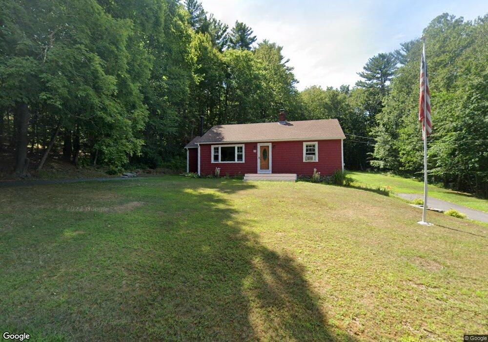
15 Norton Passway Harwinton, CT 06791
Estimated Value: $293,000 - $324,920
2
Beds
1
Bath
962
Sq Ft
$318/Sq Ft
Est. Value
About This Home
This home is located at 15 Norton Passway, Harwinton, CT 06791 and is currently estimated at $305,480, approximately $317 per square foot. 15 Norton Passway is a home located in Litchfield County with nearby schools including Harwinton Consolidated School, Har-Bur Middle School, and Lewis S. Mills High School.
Ownership History
Date
Name
Owned For
Owner Type
Purchase Details
Closed on
Dec 5, 2006
Sold by
Sullivan Jeanette F and Sullivan Dennis J
Bought by
Lockhart David J
Current Estimated Value
Home Financials for this Owner
Home Financials are based on the most recent Mortgage that was taken out on this home.
Original Mortgage
$153,400
Interest Rate
6.36%
Create a Home Valuation Report for This Property
The Home Valuation Report is an in-depth analysis detailing your home's value as well as a comparison with similar homes in the area
Home Values in the Area
Average Home Value in this Area
Purchase History
| Date | Buyer | Sale Price | Title Company |
|---|---|---|---|
| Lockhart David J | $168,000 | -- | |
| Lockhart David J | $168,000 | -- |
Source: Public Records
Mortgage History
| Date | Status | Borrower | Loan Amount |
|---|---|---|---|
| Open | Lockhart David J | $40,000 | |
| Open | Lockhart David J | $117,000 | |
| Closed | Lockhart David J | $153,400 |
Source: Public Records
Tax History Compared to Growth
Tax History
| Year | Tax Paid | Tax Assessment Tax Assessment Total Assessment is a certain percentage of the fair market value that is determined by local assessors to be the total taxable value of land and additions on the property. | Land | Improvement |
|---|---|---|---|---|
| 2025 | $3,917 | $170,310 | $64,240 | $106,070 |
| 2024 | $3,900 | $170,310 | $64,240 | $106,070 |
| 2023 | $2,780 | $95,200 | $45,890 | $49,310 |
| 2022 | $2,713 | $95,200 | $45,890 | $49,310 |
| 2021 | $2,718 | $94,710 | $45,890 | $48,820 |
| 2020 | $2,652 | $94,710 | $45,890 | $48,820 |
| 2019 | $2,652 | $94,710 | $45,890 | $48,820 |
| 2018 | $2,741 | $97,880 | $52,160 | $45,720 |
| 2017 | $2,721 | $97,880 | $52,160 | $45,720 |
| 2016 | $2,721 | $97,880 | $52,160 | $45,720 |
| 2015 | $2,672 | $97,880 | $52,160 | $45,720 |
| 2014 | $2,633 | $97,880 | $52,160 | $45,720 |
Source: Public Records
Map
Nearby Homes
- 29 Branch Rd
- 172 Pierce St
- 2 Perkins St Unit 14
- 505 Harwinton Ave Unit 27
- 505 Harwinton Ave Unit 21
- 528 Clearview Ave
- 50 King St
- 699 S Main St Unit 323
- 615 S Main St
- 59 Lincoln Ave
- 29 Hannah Way
- 241 Harwinton Ave
- 71 Tognalli Dr
- 119 Tognalli Dr
- 393 S Main St
- 84 Wilmot St
- 37 Linden St
- 184 Harwinton Ave
- 63 Barbero Dr
- 77 Marion Ave Unit 2
- 000 Norton Passway
- 21 Norton Passway
- 14 Norton Passway
- 22 Norton Passway
- 300 Scoville Hill Rd
- 296 Scoville Hill Rd
- 294 Scoville Hill Rd
- 308 Scoville Hill Rd
- 312 Scoville Hill Rd
- 292 Scoville Hill Rd
- 305 Scoville Hill Rd
- 293 Scoville Hill Rd
- 299 Scoville Hill Rd
- 320 Scoville Hill Rd
- 317 Scoville Hill Rd
- 288 Scoville Hill Rd
- 16 Branch Rd
- 27 Branch Rd
- 284 Scoville Hill Rd
- 20 Branch Rd