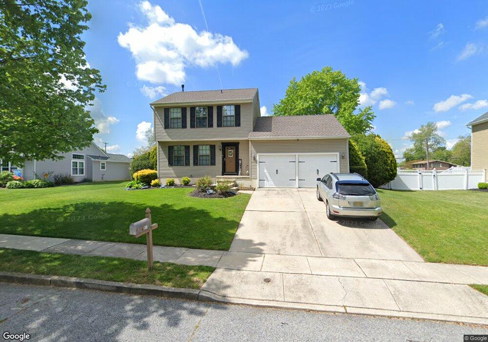
15 Oakton Dr Mantua, NJ 08051
Mantua Township NeighborhoodEstimated Value: $416,000 - $451,000
--
Bed
--
Bath
1,576
Sq Ft
$273/Sq Ft
Est. Value
About This Home
This home is located at 15 Oakton Dr, Mantua, NJ 08051 and is currently estimated at $429,966, approximately $272 per square foot. 15 Oakton Dr is a home located in Gloucester County with nearby schools including Centre City School, Clearview Regional Middle School, and Clearview Regional High School.
Ownership History
Date
Name
Owned For
Owner Type
Purchase Details
Closed on
Feb 27, 2007
Sold by
Sikora Lynn
Bought by
Grabowski Frank and Grabowski Patricia
Current Estimated Value
Home Financials for this Owner
Home Financials are based on the most recent Mortgage that was taken out on this home.
Original Mortgage
$196,000
Outstanding Balance
$118,896
Interest Rate
6.3%
Mortgage Type
Purchase Money Mortgage
Estimated Equity
$311,070
Purchase Details
Closed on
Nov 8, 1999
Sold by
Berry Marion M
Bought by
Sikora Lynn M
Create a Home Valuation Report for This Property
The Home Valuation Report is an in-depth analysis detailing your home's value as well as a comparison with similar homes in the area
Home Values in the Area
Average Home Value in this Area
Purchase History
| Date | Buyer | Sale Price | Title Company |
|---|---|---|---|
| Grabowski Frank | $245,000 | -- | |
| Sikora Lynn M | $131,000 | -- |
Source: Public Records
Mortgage History
| Date | Status | Borrower | Loan Amount |
|---|---|---|---|
| Open | Grabowski Frank | $196,000 |
Source: Public Records
Tax History Compared to Growth
Tax History
| Year | Tax Paid | Tax Assessment Tax Assessment Total Assessment is a certain percentage of the fair market value that is determined by local assessors to be the total taxable value of land and additions on the property. | Land | Improvement |
|---|---|---|---|---|
| 2025 | $7,885 | $306,200 | $108,600 | $197,600 |
| 2024 | $7,802 | $306,200 | $108,600 | $197,600 |
| 2023 | $7,802 | $306,200 | $108,600 | $197,600 |
| 2022 | $7,234 | $206,800 | $60,300 | $146,500 |
| 2021 | $7,288 | $206,800 | $60,300 | $146,500 |
| 2020 | $7,230 | $206,800 | $60,300 | $146,500 |
| 2019 | $7,108 | $206,800 | $60,300 | $146,500 |
| 2018 | $7,006 | $206,800 | $60,300 | $146,500 |
| 2017 | $6,901 | $206,800 | $60,300 | $146,500 |
| 2016 | $6,822 | $206,800 | $60,300 | $146,500 |
| 2015 | $6,655 | $206,800 | $60,300 | $146,500 |
| 2014 | $6,431 | $206,800 | $60,300 | $146,500 |
Source: Public Records
Map
Nearby Homes
- 17 Oakton Dr
- 333 Jackson Rd
- 284 Columbus Dr
- 41 Woodbrook Dr Unit C041
- 26 Woodstream Ct
- 290 Montgomery Dr
- 590 Bridgeton Pike
- 119 Monroe Ave
- 485 Harrison Ave
- 36 Bluebird Rd
- 204 W Landing Rd
- 380 Heritage Rd
- 325 Bridgeton Pike
- 261 Tony Cir
- 190 Mockingbird Ln
- 580 Mount Royal Rd
- 155 Whippoorwill Way
- 1433 Tristram Cir
- 8 Barry Dr
- 608 Main St