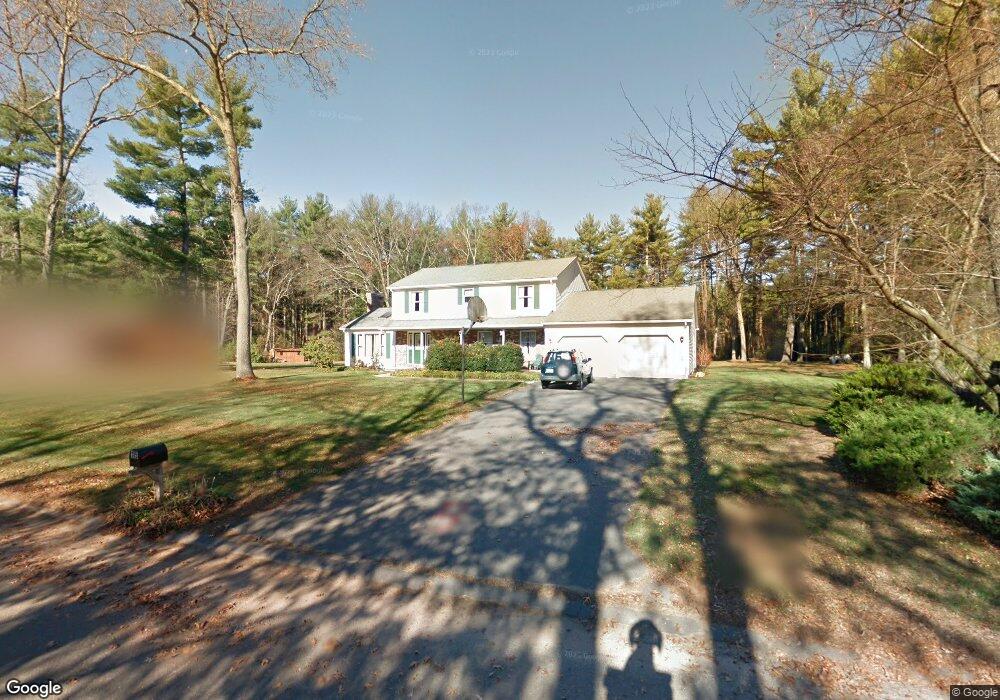
15 Pheasant Dr Holyoke, MA 01040
Estimated Value: $407,000 - $503,643
4
Beds
3
Baths
2,264
Sq Ft
$212/Sq Ft
Est. Value
About This Home
This home is located at 15 Pheasant Dr, Holyoke, MA 01040 and is currently estimated at $478,911, approximately $211 per square foot. 15 Pheasant Dr is a home located in Hampden County with nearby schools including Harriet Bishop Elementary School, Lt. Elmer J. McMahon Elementary School, and Holyoke High School.
Ownership History
Date
Name
Owned For
Owner Type
Purchase Details
Closed on
Sep 11, 2018
Sold by
Shevlin Steven F
Bought by
Tripathi Elizabeth A and Shevlin Patrick J
Current Estimated Value
Purchase Details
Closed on
Jan 4, 1988
Sold by
B & L Nominee Trust
Bought by
Shevlin Steven F
Purchase Details
Closed on
Oct 15, 1987
Sold by
Theroux John L
Bought by
Stathis Peter
Create a Home Valuation Report for This Property
The Home Valuation Report is an in-depth analysis detailing your home's value as well as a comparison with similar homes in the area
Home Values in the Area
Average Home Value in this Area
Purchase History
| Date | Buyer | Sale Price | Title Company |
|---|---|---|---|
| Tripathi Elizabeth A | -- | -- | |
| Tripathi Elizabeth A | -- | -- | |
| Shevlin Steven F | $208,500 | -- | |
| Stathis Peter | $190,000 | -- |
Source: Public Records
Mortgage History
| Date | Status | Borrower | Loan Amount |
|---|---|---|---|
| Previous Owner | Stathis Peter | $65,600 | |
| Previous Owner | Stathis Peter | $90,000 | |
| Previous Owner | Stathis Peter | $100,000 |
Source: Public Records
Tax History Compared to Growth
Tax History
| Year | Tax Paid | Tax Assessment Tax Assessment Total Assessment is a certain percentage of the fair market value that is determined by local assessors to be the total taxable value of land and additions on the property. | Land | Improvement |
|---|---|---|---|---|
| 2025 | $7,681 | $439,900 | $74,200 | $365,700 |
| 2024 | $7,417 | $391,400 | $70,700 | $320,700 |
| 2023 | $7,067 | $376,700 | $70,700 | $306,000 |
| 2022 | $6,756 | $350,800 | $70,700 | $280,100 |
| 2021 | $6,465 | $335,500 | $67,600 | $267,900 |
| 2020 | $6,111 | $320,300 | $67,600 | $252,700 |
| 2019 | $6,159 | $319,300 | $67,600 | $251,700 |
| 2018 | $5,917 | $306,200 | $67,600 | $238,600 |
| 2017 | $5,870 | $306,200 | $67,600 | $238,600 |
| 2016 | $5,759 | $301,200 | $69,800 | $231,400 |
| 2015 | $5,735 | $301,200 | $69,800 | $231,400 |
Source: Public Records
Map
Nearby Homes
- 405 Rock Valley Rd
- 4 Fitch Farm Way
- 36 County Rd
- 103 Dupuis Rd
- Lot 57 White Loaf Rd
- 94 Pequot Rd (Rear)
- 150 Middle Rd
- 64 Old Stage Rd
- 7 Western View Rd
- 56 Pomeroy St
- Lot A Homestead Ave
- 33 Maple Crest Cir Unit D
- 15 Maple Crest Cir Unit D
- 34 Maple Crest Cir Unit B
- 59 Campbell Dr
- 14 Eastwood Dr
- 794 Homestead Ave
- 369 College Hwy
- 22 Eastwood Ln
- 0 Char Dr