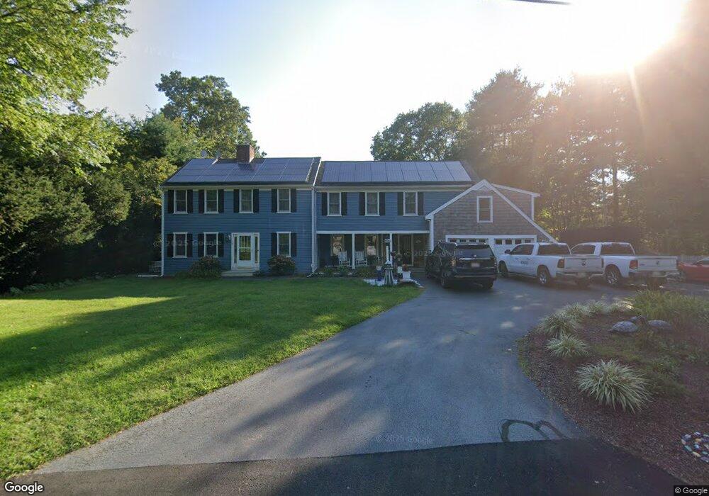
15 Rosewood Ln Cotuit, MA 02635
Cotuit NeighborhoodEstimated Value: $891,000 - $1,075,000
5
Beds
3
Baths
2,764
Sq Ft
$349/Sq Ft
Est. Value
About This Home
This home is located at 15 Rosewood Ln, Cotuit, MA 02635 and is currently estimated at $964,324, approximately $348 per square foot. 15 Rosewood Ln is a home located in Barnstable County with nearby schools including West Villages Elementary School, Barnstable United Elementary School, and Barnstable Intermediate School.
Ownership History
Date
Name
Owned For
Owner Type
Purchase Details
Closed on
Aug 11, 2011
Sold by
Cranks Della
Bought by
Pierce Melissa
Current Estimated Value
Purchase Details
Closed on
Nov 15, 2005
Sold by
Cohen Alison M
Bought by
Cranks Della
Purchase Details
Closed on
Jan 10, 1990
Sold by
Edward James Gilmer
Bought by
Cohen Richard A
Create a Home Valuation Report for This Property
The Home Valuation Report is an in-depth analysis detailing your home's value as well as a comparison with similar homes in the area
Home Values in the Area
Average Home Value in this Area
Purchase History
| Date | Buyer | Sale Price | Title Company |
|---|---|---|---|
| Pierce Melissa | $60,000 | -- | |
| Cranks Della | $400,000 | -- | |
| Cohen Richard A | $186,000 | -- |
Source: Public Records
Mortgage History
| Date | Status | Borrower | Loan Amount |
|---|---|---|---|
| Open | Cohen Richard A | $200,000 | |
| Previous Owner | Cohen Richard A | $35,000 | |
| Previous Owner | Cohen Richard A | $130,000 |
Source: Public Records
Tax History Compared to Growth
Tax History
| Year | Tax Paid | Tax Assessment Tax Assessment Total Assessment is a certain percentage of the fair market value that is determined by local assessors to be the total taxable value of land and additions on the property. | Land | Improvement |
|---|---|---|---|---|
| 2025 | $7,310 | $875,500 | $218,700 | $656,800 |
| 2024 | $6,589 | $836,200 | $218,700 | $617,500 |
| 2023 | $6,173 | $737,500 | $198,800 | $538,700 |
| 2022 | $6,045 | $584,600 | $136,700 | $447,900 |
| 2021 | $0 | $553,200 | $138,800 | $414,400 |
| 2020 | $5,866 | $500,900 | $138,800 | $362,100 |
| 2019 | $6,122 | $515,300 | $147,200 | $368,100 |
| 2018 | $0 | $493,000 | $171,600 | $321,400 |
| 2017 | $0 | $485,200 | $171,600 | $313,600 |
| 2016 | $5,603 | $486,800 | $173,200 | $313,600 |
| 2015 | $5,257 | $456,300 | $136,600 | $319,700 |
Source: Public Records
Map
Nearby Homes
- 75 Bob White Run
- 783
- 4701 Falmouth Rd
- 170 Forest Hills Rd
- 6 Mayfair Ct
- 6 Mayfair Ct Unit 6
- 30 Windsor Point
- 226 Dunrobin Rd
- 4 Bishops Park
- 95 Brittany Dr
- 220 Dunrobin Rd
- 5 Darby Point Unit 5
- 22 Stratford Ridge Unit 22
- 16 Spring Brook Ln
- 78 Brittany Dr
- 70 Cape Dr Unit 14D
- 70 Cape Dr Unit 11D
- 70 Cape Dr Unit 11D
- 45 Pequot Rd
- 9 Tarragon Cir
- 27 Rosewood Ln
- 194 Sandalwood Dr
- 178 Sandalwood Dr
- 16 Rosewood Ln
- 216 Sandalwood Dr
- 30 Rosewood Ln
- 193 Sandalwood Dr
- 52 Curlew Way
- 205 Sandalwood Dr
- 181 Sandalwood Dr
- 164 Sandalwood Dr
- 66 Curlew Way
- 38 Curlew Way
- 217 Sandalwood Dr
- 169 Sandalwood Dr
- 38 Rosewood Ln
- 19 Eastwood Ln
- 234 Sandalwood Dr
- 148 Sandalwood Dr
- 22 Curlew Way