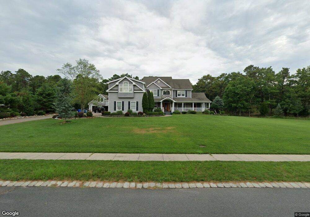
15 Royal Oak Ct West Creek, NJ 08092
Stafford NeighborhoodEstimated Value: $1,089,000 - $1,527,000
4
Beds
4
Baths
3,579
Sq Ft
$353/Sq Ft
Est. Value
About This Home
This home is located at 15 Royal Oak Ct, West Creek, NJ 08092 and is currently estimated at $1,262,231, approximately $352 per square foot. 15 Royal Oak Ct is a home located in Ocean County with nearby schools including Oxycocus Elementary School, Ocean Acres Elementary School, and McKinley Avenue Elementary School.
Ownership History
Date
Name
Owned For
Owner Type
Purchase Details
Closed on
Nov 19, 2018
Sold by
Schuler Therese M
Bought by
Schuler Kevin J
Current Estimated Value
Purchase Details
Closed on
Aug 2, 2011
Sold by
Wunnenberg William Eugene and Wunnenberg Suzanne
Bought by
Schuler Kevin J and Schuler Therese M
Purchase Details
Closed on
Feb 17, 2006
Sold by
Andev Corp
Bought by
Wunnenberg William Eugene and Wunnenberg Suzanne G
Home Financials for this Owner
Home Financials are based on the most recent Mortgage that was taken out on this home.
Original Mortgage
$183,000
Interest Rate
6.28%
Mortgage Type
Credit Line Revolving
Create a Home Valuation Report for This Property
The Home Valuation Report is an in-depth analysis detailing your home's value as well as a comparison with similar homes in the area
Home Values in the Area
Average Home Value in this Area
Purchase History
| Date | Buyer | Sale Price | Title Company |
|---|---|---|---|
| Schuler Kevin J | -- | None Available | |
| Schuler Kevin J | $579,000 | None Available | |
| Wunnenberg William Eugene | $750,000 | None Available |
Source: Public Records
Mortgage History
| Date | Status | Borrower | Loan Amount |
|---|---|---|---|
| Closed | Wunnenberg William Eugene | $183,000 | |
| Open | Wunnenberg William Eugene | $417,000 |
Source: Public Records
Tax History Compared to Growth
Tax History
| Year | Tax Paid | Tax Assessment Tax Assessment Total Assessment is a certain percentage of the fair market value that is determined by local assessors to be the total taxable value of land and additions on the property. | Land | Improvement |
|---|---|---|---|---|
| 2025 | $17,408 | $701,100 | $134,800 | $566,300 |
| 2024 | $17,240 | $701,100 | $134,800 | $566,300 |
| 2023 | $16,504 | $701,100 | $134,800 | $566,300 |
| 2022 | $16,504 | $701,100 | $134,800 | $566,300 |
| 2021 | $16,280 | $701,100 | $134,800 | $566,300 |
| 2020 | $12,727 | $547,400 | $134,800 | $412,600 |
| 2019 | $12,546 | $547,400 | $134,800 | $412,600 |
| 2018 | $12,470 | $547,400 | $134,800 | $412,600 |
| 2017 | $12,692 | $539,400 | $134,800 | $404,600 |
| 2016 | $12,563 | $539,400 | $134,800 | $404,600 |
| 2015 | $12,120 | $539,400 | $134,800 | $404,600 |
| 2014 | $11,919 | $523,900 | $134,800 | $389,100 |
Source: Public Records
Map
Nearby Homes
- 71 Oak Ridge Ln
- 75 Perry Ln
- 36 Fort Lee Dr
- 30 Fort Lee Dr
- 40 Pine Grove Ave
- 15 Cedar Hill Dr
- 1076 S Main St
- 3 Bryce Ln Unit 1502
- 3 Bryce Ln
- 106 Bryce Ln Unit 802
- 303 S Lakeshore Dr
- 670 Julian Ct
- 34 Holly Rd
- 138 Bradshaw Dr
- 26 Osprey Ave
- 49 Oxycocus Rd
- 50 Osprey
- 155 Corliss Way
- 84 Jennings Rd
- 0 Dinner Point Unit NJOC2036750