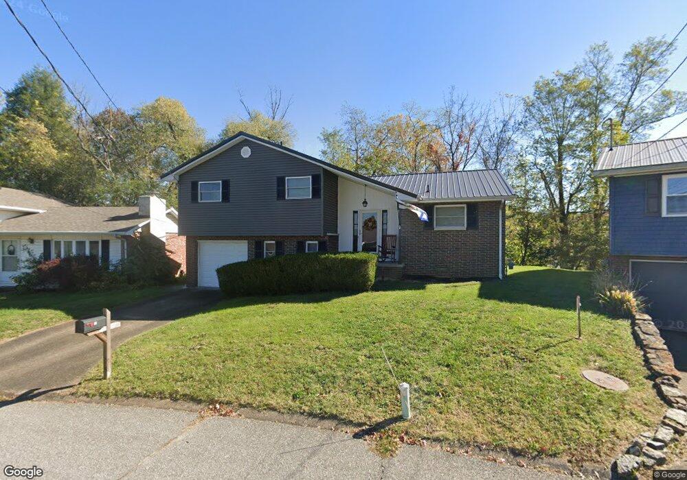
15 Simpson Dr Huntington, WV 25705
Southeast Hills NeighborhoodEstimated Value: $150,000 - $212,503
3
Beds
2
Baths
1,624
Sq Ft
$111/Sq Ft
Est. Value
About This Home
This home is located at 15 Simpson Dr, Huntington, WV 25705 and is currently estimated at $180,376, approximately $111 per square foot. 15 Simpson Dr is a home located in Cabell County with nearby schools including Explorer Academy, Huntington East Middle School, and Huntington High School.
Ownership History
Date
Name
Owned For
Owner Type
Purchase Details
Closed on
Aug 24, 2020
Sold by
Booker Brent E
Bought by
Ross Joshua C
Current Estimated Value
Home Financials for this Owner
Home Financials are based on the most recent Mortgage that was taken out on this home.
Original Mortgage
$82,400
Outstanding Balance
$73,259
Interest Rate
3%
Mortgage Type
New Conventional
Estimated Equity
$107,117
Purchase Details
Closed on
Jun 15, 2017
Sold by
Fryson Susan K
Bought by
Booker Brent E
Create a Home Valuation Report for This Property
The Home Valuation Report is an in-depth analysis detailing your home's value as well as a comparison with similar homes in the area
Home Values in the Area
Average Home Value in this Area
Purchase History
| Date | Buyer | Sale Price | Title Company |
|---|---|---|---|
| Ross Joshua C | $103,000 | Bestitle | |
| Booker Brent E | -- | None Available |
Source: Public Records
Mortgage History
| Date | Status | Borrower | Loan Amount |
|---|---|---|---|
| Open | Ross Joshua C | $82,400 |
Source: Public Records
Tax History Compared to Growth
Tax History
| Year | Tax Paid | Tax Assessment Tax Assessment Total Assessment is a certain percentage of the fair market value that is determined by local assessors to be the total taxable value of land and additions on the property. | Land | Improvement |
|---|---|---|---|---|
| 2024 | $1,221 | $66,960 | $17,160 | $49,800 |
| 2023 | $1,131 | $66,960 | $17,160 | $49,800 |
| 2022 | $1,140 | $66,960 | $17,160 | $49,800 |
| 2021 | $1,146 | $66,960 | $17,160 | $49,800 |
| 2020 | $1,061 | $64,200 | $17,160 | $47,040 |
| 2019 | $1,086 | $64,200 | $17,160 | $47,040 |
| 2018 | $936 | $55,260 | $13,740 | $41,520 |
| 2017 | $937 | $55,260 | $13,740 | $41,520 |
| 2016 | $936 | $55,260 | $13,740 | $41,520 |
| 2015 | $985 | $58,260 | $13,740 | $44,520 |
| 2014 | $1,085 | $64,140 | $13,740 | $50,400 |
Source: Public Records
Map
Nearby Homes
- 929 Norway Ave
- 935 Norway Ave
- 1778 Woodward Terrace
- 1771 Woodward Terrace
- 1770 Woodward Terrace
- 887 Norway Ave
- 5 Highland Dr Unit PT LOT 5 Rankin Sub
- 3663 Thomas Ave
- 58 Holley Ave
- 49 Blossom Dr
- 983 Turner Rd
- 2932 Thomas Ave
- 3119 Brereton Ct
- 12 Romar Ct
- 3105 Brereton Ct
- Lot 31 Seneca Rd
- 131 Elwood Ave
- 157 Bryn Myrr Dr Unit 3356 Bryn Myrr Dr
- 109 River Ave
- 118