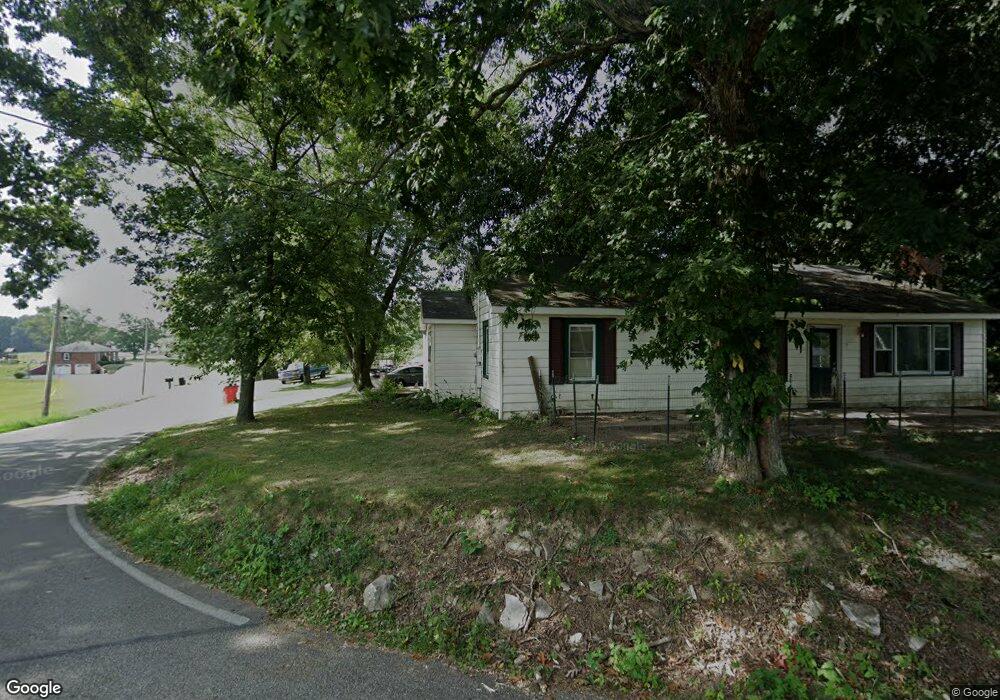
15 Sky Aire Rd NW Corydon, IN 47112
Estimated Value: $254,089 - $332,000
3
Beds
1
Bath
1,484
Sq Ft
$190/Sq Ft
Est. Value
About This Home
This home is located at 15 Sky Aire Rd NW, Corydon, IN 47112 and is currently estimated at $282,272, approximately $190 per square foot. 15 Sky Aire Rd NW is a home located in Harrison County with nearby schools including North Harrison High School.
Ownership History
Date
Name
Owned For
Owner Type
Purchase Details
Closed on
May 14, 2013
Sold by
Joe Anthony Arbuckle
Bought by
William Vest
Current Estimated Value
Create a Home Valuation Report for This Property
The Home Valuation Report is an in-depth analysis detailing your home's value as well as a comparison with similar homes in the area
Home Values in the Area
Average Home Value in this Area
Purchase History
| Date | Buyer | Sale Price | Title Company |
|---|---|---|---|
| William Vest | $71,000 | Mull & Heinz, Llc |
Source: Public Records
Tax History Compared to Growth
Tax History
| Year | Tax Paid | Tax Assessment Tax Assessment Total Assessment is a certain percentage of the fair market value that is determined by local assessors to be the total taxable value of land and additions on the property. | Land | Improvement |
|---|---|---|---|---|
| 2024 | $2,153 | $179,200 | $47,800 | $131,400 |
| 2023 | $2,197 | $169,500 | $44,800 | $124,700 |
| 2022 | $1,905 | $146,000 | $39,800 | $106,200 |
| 2021 | $1,688 | $124,800 | $32,300 | $92,500 |
| 2020 | $1,632 | $116,100 | $27,300 | $88,800 |
| 2019 | $1,555 | $110,500 | $24,600 | $85,900 |
| 2018 | $1,493 | $106,600 | $24,600 | $82,000 |
| 2017 | $1,385 | $103,800 | $24,600 | $79,200 |
| 2016 | $1,236 | $102,900 | $24,600 | $78,300 |
| 2014 | $1,096 | $97,500 | $22,400 | $75,100 |
Source: Public Records
Map
Nearby Homes
- 4425 Old Highway 135 NE
- 974 Pinewood Trail NE
- 261 Indian Hills Dr NE
- 0 Lost Creek Rd NE
- 1121 Poplar Trace Way NW
- 710 Sky Way Dr NW
- 7045 Corydon Junction Rd NE
- 1230 Karen Ave NW
- 1414 Deer Ridge Way NE
- 1944 Andrew Ct NW
- 151 Old State Road 64 NE
- 895 Brigetta Dr NE
- The Paislee Plan at Poplar Trace
- The Eleanor Plan at Poplar Trace
- The Bedford Plan at Poplar Trace
- The Ivy Plan at Poplar Trace
- The Harrison Plan at Poplar Trace
- 1052 Poplar Trace Way
- 1371 Poplar Trace Way NW
- DUPONT Plan at Poplar Trace
- 4674 Angelo Rd NE
- 35 Sky Aire Rd NE
- 55 Sky Aire Rd NE
- 40 Sky Aire Rd NW
- 4645 Angelo Rd NW
- 4632 Angelo Rd NW
- 105 Sky Aire Rd NE
- 105 Sky Aire Rd NE
- 4605 Angelo Rd NW
- 4650 Angelo Rd
- 175 Sky Aire Rd NW
- 4593 Angelo Rd NW
- 100 Sky Aire Rd NW
- 4505 Angelo Rd NW
- 30 Ponder Ln NE
- 0 Ponder Ln NE Unit 201101010
- 0 Ponder Ln NE Unit 201103145
- 0 Ponder Ln NE Unit 201105567
- 0 Ponder Ln NE Unit Lot3 201200584
- 0 Ponder Ln NE