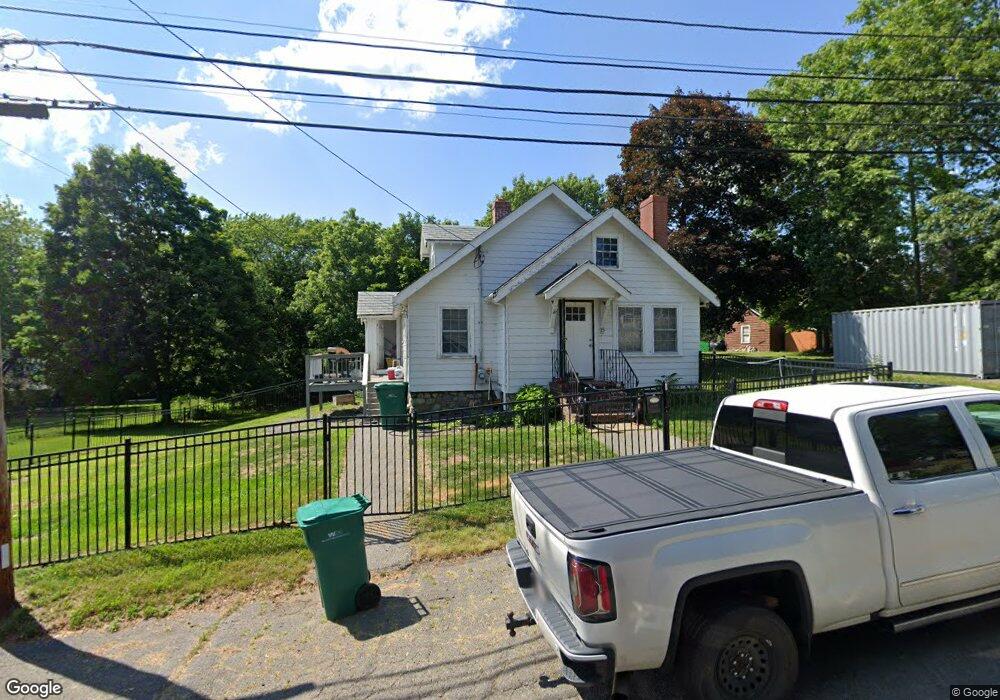
15 Sparhawk Rd Lynn, MA 01905
Upper Walnut Street NeighborhoodEstimated Value: $583,000 - $677,000
3
Beds
1
Bath
1,523
Sq Ft
$402/Sq Ft
Est. Value
About This Home
This home is located at 15 Sparhawk Rd, Lynn, MA 01905 and is currently estimated at $612,783, approximately $402 per square foot. 15 Sparhawk Rd is a home located in Essex County with nearby schools including Cromwell-Wright Elementary School, Julia F. Callahan Elementary School, and William R. Fallon School.
Ownership History
Date
Name
Owned For
Owner Type
Purchase Details
Closed on
Apr 23, 2025
Sold by
Odonnell William H
Bought by
15 Sparhawk Road Llc
Current Estimated Value
Purchase Details
Closed on
Jan 11, 2023
Sold by
15 Sparhawk Road Rt and Odonnell
Bought by
Odonnell William J
Purchase Details
Closed on
Jan 11, 2017
Sold by
Odonnell William H and Odonnell Joan
Bought by
15 Sparhawk Road Rt and Odonnell
Purchase Details
Closed on
Jan 14, 2013
Sold by
Odonnell William H
Bought by
Odonnell William H and Odonnell Joan
Create a Home Valuation Report for This Property
The Home Valuation Report is an in-depth analysis detailing your home's value as well as a comparison with similar homes in the area
Home Values in the Area
Average Home Value in this Area
Purchase History
| Date | Buyer | Sale Price | Title Company |
|---|---|---|---|
| 15 Sparhawk Road Llc | -- | None Available | |
| 15 Sparhawk Road Llc | -- | None Available | |
| 15 Sparhawk Road Llc | -- | None Available | |
| Odonnell William J | -- | None Available | |
| Odonnell William J | -- | None Available | |
| Odonnell William J | -- | None Available | |
| 15 Sparhawk Road Rt | -- | -- | |
| 15 Sparhawk Road Rt | -- | -- | |
| Odonnell William H | -- | -- | |
| Odonnell William H | -- | -- |
Source: Public Records
Tax History Compared to Growth
Tax History
| Year | Tax Paid | Tax Assessment Tax Assessment Total Assessment is a certain percentage of the fair market value that is determined by local assessors to be the total taxable value of land and additions on the property. | Land | Improvement |
|---|---|---|---|---|
| 2025 | $5,328 | $514,300 | $229,800 | $284,500 |
| 2024 | $5,193 | $493,200 | $228,300 | $264,900 |
| 2023 | $4,991 | $447,600 | $210,800 | $236,800 |
| 2022 | $5,145 | $413,900 | $193,600 | $220,300 |
| 2021 | $4,795 | $368,000 | $180,600 | $187,400 |
| 2020 | $4,543 | $339,000 | $161,100 | $177,900 |
| 2019 | $4,738 | $331,300 | $165,600 | $165,700 |
| 2018 | $4,245 | $280,200 | $155,100 | $125,100 |
| 2017 | $3,942 | $252,700 | $135,100 | $117,600 |
| 2016 | $3,848 | $237,800 | $127,700 | $110,100 |
| 2015 | $3,925 | $234,300 | $126,200 | $108,100 |
Source: Public Records
Map
Nearby Homes
- 32 Birch Brook Rd Unit 27
- 32 Birch Brook Rd Unit 16
- 32 Birch Brook Rd Unit 1
- 32 Birch Brook Rd Unit 25
- 32 Birch Brook Rd Unit 22
- 32 Birch Brook Rd Unit 28
- 268 Walnut St
- 110 Holyoke St
- 35 Curran Rd
- 92-94 Newton Ave
- 20 Houston St
- 14 Atkinson St
- 27 Bradford Terrace
- 725 Boston St
- 28 Wyman St
- 8 Newcomb Ave
- 100 Ashland St
- 93 Robinson St
- 771 Boston St
- 29 Fenton Ave
- 23 Sparhawk Rd
- 452 Walnut St
- 3 Sparhawk Rd
- 460 Walnut St
- 8 Sparhawk Rd
- 20 Sparhawk Rd
- 6 Sparhawk Rd Unit 2
- 6 Sparhawk Rd
- 6 Sparhawk Rd Unit 6
- 4 Sparhawk Rd
- 575 Walnut St
- 16 Ocallaghan Way
- 22 Sparhawk Rd Unit A
- 22 Sparhawk Rd Unit B
- 22 Ocallaghan Way
- 439 Walnut St
- 439 Walnut St Unit single fam
- 12 Ocallaghan Way
- 12 O'Callaghan Way
- 28 Ocallaghan Way