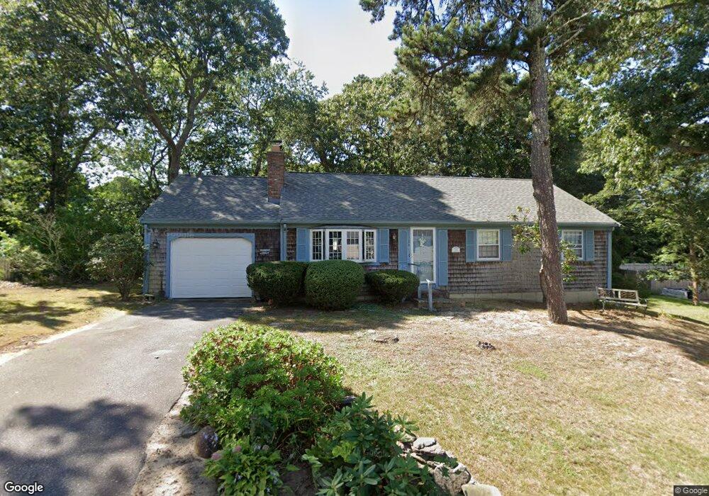
15 Waggon Rd Yarmouth Port, MA 02675
Yarmouth Port NeighborhoodEstimated Value: $536,000 - $713,000
3
Beds
2
Baths
1,092
Sq Ft
$552/Sq Ft
Est. Value
About This Home
This home is located at 15 Waggon Rd, Yarmouth Port, MA 02675 and is currently estimated at $602,771, approximately $551 per square foot. 15 Waggon Rd is a home located in Barnstable County with nearby schools including Dennis-Yarmouth Regional High School and St. Pius X. School.
Ownership History
Date
Name
Owned For
Owner Type
Purchase Details
Closed on
Nov 30, 2016
Sold by
Tardo Frank S and Tardo Marie E
Bought by
Story Stephanie M and Tardo Frank S
Current Estimated Value
Purchase Details
Closed on
Aug 14, 2015
Sold by
15 Waggon Road Rt and Tardo Frank S
Bought by
Tardo Frank S and Tardo Marie E
Purchase Details
Closed on
Mar 4, 1998
Sold by
Wallace Delmar and Wallace Alma S
Bought by
Tardo Frank S and Tardo Marie
Home Financials for this Owner
Home Financials are based on the most recent Mortgage that was taken out on this home.
Original Mortgage
$45,000
Interest Rate
6.93%
Mortgage Type
Purchase Money Mortgage
Create a Home Valuation Report for This Property
The Home Valuation Report is an in-depth analysis detailing your home's value as well as a comparison with similar homes in the area
Home Values in the Area
Average Home Value in this Area
Purchase History
| Date | Buyer | Sale Price | Title Company |
|---|---|---|---|
| Story Stephanie M | -- | -- | |
| Tardo Frank S | -- | -- | |
| Tardo Frank S | $111,000 | -- |
Source: Public Records
Mortgage History
| Date | Status | Borrower | Loan Amount |
|---|---|---|---|
| Previous Owner | Tardo Frank S | $45,000 |
Source: Public Records
Tax History Compared to Growth
Tax History
| Year | Tax Paid | Tax Assessment Tax Assessment Total Assessment is a certain percentage of the fair market value that is determined by local assessors to be the total taxable value of land and additions on the property. | Land | Improvement |
|---|---|---|---|---|
| 2025 | $3,376 | $476,800 | $165,700 | $311,100 |
| 2024 | $3,172 | $429,800 | $144,100 | $285,700 |
| 2023 | $3,114 | $384,000 | $131,000 | $253,000 |
| 2022 | $2,994 | $326,100 | $125,000 | $201,100 |
| 2021 | $2,823 | $295,300 | $125,000 | $170,300 |
| 2020 | $2,841 | $284,100 | $132,300 | $151,800 |
| 2019 | $2,644 | $261,800 | $132,300 | $129,500 |
| 2018 | $2,467 | $239,700 | $110,200 | $129,500 |
| 2017 | $2,402 | $239,700 | $110,200 | $129,500 |
| 2016 | $2,304 | $230,900 | $101,400 | $129,500 |
| 2015 | $2,324 | $231,500 | $97,000 | $134,500 |
Source: Public Records
Map
Nearby Homes
- 44 Stratford Ln
- 86 Pompano Rd
- 43 Canterbury Rd
- 34 Kates Path
- 34 Kates Path Unit 34
- 6 Nimble Hill Dr
- 64 Kates Path
- 17 Kates Path Unit A
- 228 Kates Path
- 25 Oak Glen Village Unit 25
- 25 Oak Glen
- 50 John Hall Cartway
- 50 John Hall Cartway Unit 50
- 42 John Hall Cartway Unit 42
- 1 Barnacle Rd
- 7 Forest Gate Unit 7
- 111 Merchant Ave
- 2 Pine Grove
- 59 Main St Unit 19-2
- 59 Route 6a Unit 29-4