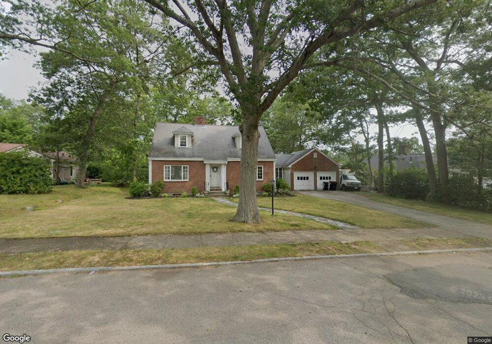
15 West Ave Brockton, MA 02301
Winters Corner NeighborhoodEstimated Value: $557,000 - $689,000
3
Beds
2
Baths
1,458
Sq Ft
$408/Sq Ft
Est. Value
About This Home
This home is located at 15 West Ave, Brockton, MA 02301 and is currently estimated at $594,655, approximately $407 per square foot. 15 West Ave is a home located in Plymouth County with nearby schools including Manthala George Jr. School, Hancock Elementary School, and Louis F Angelo Elementary School.
Ownership History
Date
Name
Owned For
Owner Type
Purchase Details
Closed on
Dec 28, 2011
Sold by
Jones Dellarita L
Bought by
Jones Dellarita L
Current Estimated Value
Purchase Details
Closed on
May 18, 1998
Sold by
Katzew Amy B
Bought by
Gaskins Dellarita L
Home Financials for this Owner
Home Financials are based on the most recent Mortgage that was taken out on this home.
Original Mortgage
$118,655
Interest Rate
7.08%
Mortgage Type
Purchase Money Mortgage
Create a Home Valuation Report for This Property
The Home Valuation Report is an in-depth analysis detailing your home's value as well as a comparison with similar homes in the area
Home Values in the Area
Average Home Value in this Area
Purchase History
| Date | Buyer | Sale Price | Title Company |
|---|---|---|---|
| Jones Dellarita L | -- | -- | |
| Gaskins Dellarita L | $124,901 | -- |
Source: Public Records
Mortgage History
| Date | Status | Borrower | Loan Amount |
|---|---|---|---|
| Previous Owner | Gaskins Dellarita L | $25,000 | |
| Previous Owner | Gaskins Dellarita L | $145,000 | |
| Previous Owner | Gaskins Dellarita L | $118,655 | |
| Closed | Gaskins Dellarita L | $8,035 |
Source: Public Records
Tax History
| Year | Tax Paid | Tax Assessment Tax Assessment Total Assessment is a certain percentage of the fair market value that is determined by local assessors to be the total taxable value of land and additions on the property. | Land | Improvement |
|---|---|---|---|---|
| 2025 | $6,147 | $507,600 | $152,500 | $355,100 |
| 2024 | $5,713 | $475,300 | $152,500 | $322,800 |
| 2023 | $5,376 | $414,200 | $118,000 | $296,200 |
| 2022 | $5,170 | $370,100 | $107,500 | $262,600 |
| 2021 | $5,061 | $349,000 | $99,800 | $249,200 |
| 2020 | $4,606 | $304,000 | $95,600 | $208,400 |
| 2019 | $4,828 | $310,700 | $89,400 | $221,300 |
| 2018 | $5,515 | $285,000 | $89,400 | $195,600 |
| 2017 | $4,318 | $268,200 | $89,400 | $178,800 |
| 2016 | $4,371 | $251,800 | $85,600 | $166,200 |
| 2015 | $4,583 | $252,500 | $85,600 | $166,900 |
| 2014 | $4,186 | $230,900 | $85,600 | $145,300 |
Source: Public Records
Map
Nearby Homes
- 109 Lenox St
- 47 N Belcher Ave
- 131 Moraine St
- 69 W Elm Terrace Unit 1
- 29 Auna Dr Unit 3
- 433 W Elm St Unit 2
- 11 Auna Dr Unit 6
- 425 W Elm St Unit 7
- 436 Pleasant St
- 18 Belmont Place
- 75 Colonel Bell Dr Unit 77-11
- 130 Braemoor Rd
- 81 Colonel Bell Dr Unit 9
- 193 Boylston St
- 77 Highland Terrace
- 97 Colonel Bell Dr Unit 8
- 155 Rockland Dr
- 990 Pleasant St
- 66 Cross Ave
- 102 Alandale Ave
Your Personal Tour Guide
Ask me questions while you tour the home.