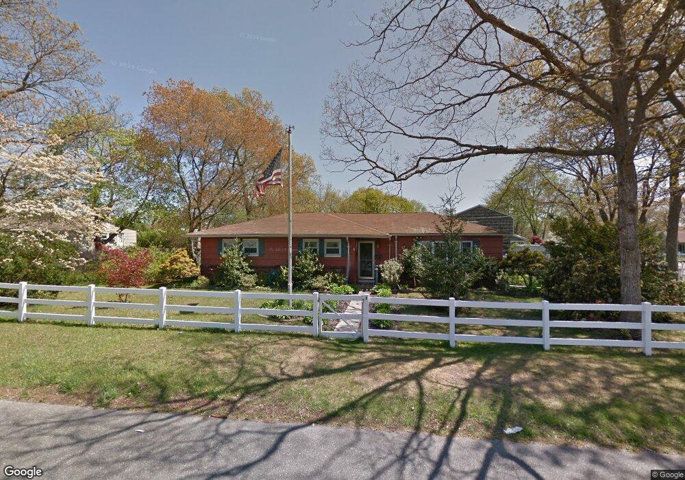
15 Wilson St Blue Point, NY 11715
Estimated Value: $665,002 - $783,000
4
Beds
2
Baths
1,666
Sq Ft
$422/Sq Ft
Est. Value
About This Home
This home is located at 15 Wilson St, Blue Point, NY 11715 and is currently estimated at $703,751, approximately $422 per square foot. 15 Wilson St is a home located in Suffolk County with nearby schools including James Wilson Young Middle School, Bayport Blue Point High School, and Holy Angels Regional School.
Ownership History
Date
Name
Owned For
Owner Type
Purchase Details
Closed on
Jul 22, 2021
Sold by
Sheehan Neal and Sheehan Jeannette
Bought by
Church Sean and Church Rebecca
Current Estimated Value
Purchase Details
Closed on
Jul 2, 1998
Sold by
Thommen Arthur C and Thommen Carole L
Bought by
Chopik Richard J and Chopik Lois
Home Financials for this Owner
Home Financials are based on the most recent Mortgage that was taken out on this home.
Original Mortgage
$138,037
Interest Rate
7.02%
Mortgage Type
FHA
Create a Home Valuation Report for This Property
The Home Valuation Report is an in-depth analysis detailing your home's value as well as a comparison with similar homes in the area
Home Values in the Area
Average Home Value in this Area
Purchase History
| Date | Buyer | Sale Price | Title Company |
|---|---|---|---|
| Church Sean | $525,000 | None Available | |
| Chopik Richard J | $150,000 | Commonwealth Land Title Ins | |
| Chopik Richard J | $150,000 | Commonwealth Land Title Ins |
Source: Public Records
Mortgage History
| Date | Status | Borrower | Loan Amount |
|---|---|---|---|
| Previous Owner | Chopik Richard J | $138,037 |
Source: Public Records
Tax History Compared to Growth
Tax History
| Year | Tax Paid | Tax Assessment Tax Assessment Total Assessment is a certain percentage of the fair market value that is determined by local assessors to be the total taxable value of land and additions on the property. | Land | Improvement |
|---|---|---|---|---|
| 2024 | $11,669 | $2,400 | $350 | $2,050 |
| 2023 | $11,669 | $2,400 | $350 | $2,050 |
| 2022 | $7,202 | $2,400 | $350 | $2,050 |
| 2021 | $7,202 | $2,400 | $350 | $2,050 |
| 2020 | $7,567 | $2,400 | $350 | $2,050 |
| 2019 | $7,567 | $0 | $0 | $0 |
| 2018 | $7,174 | $2,400 | $350 | $2,050 |
| 2017 | $7,174 | $2,400 | $350 | $2,050 |
| 2016 | $7,325 | $2,400 | $350 | $2,050 |
| 2015 | -- | $2,400 | $350 | $2,050 |
| 2014 | -- | $2,400 | $350 | $2,050 |
Source: Public Records
Map
Nearby Homes
- 92 Park St
- 53 Oyster Cove Ln
- 25 Oyster Cove Ln
- 19 Kuebler St
- 2 Oyster Cove Ln
- 62 Hill St
- 63 Division Ave
- 42 Corey Ave
- 49 S Summit Ave
- 146 Fairharbor Dr
- 151 Fairharbor Dr Unit 151
- 159 Fairharbor Dr
- 93 S Summit Ave
- 181 Blue Point Ave
- 145 Fair Harbor Dr Unit 145
- 135 Fair Harbor Dr Unit 135
- 63 Fair Harbor Dr Unit 63
- 55 Fair Harbor Dr Unit 55
- 54 Fair Harbor Dr Unit 54
- 8 Atlantic Ave