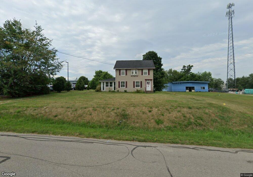
150 Branstetter St Wooster, OH 44691
Estimated Value: $110,000 - $181,000
3
Beds
1
Bath
1,352
Sq Ft
$114/Sq Ft
Est. Value
About This Home
This home is located at 150 Branstetter St, Wooster, OH 44691 and is currently estimated at $153,885, approximately $113 per square foot. 150 Branstetter St is a home located in Wayne County with nearby schools including Parkview Elementary School, Edgewood Middle School, and Wooster High School.
Ownership History
Date
Name
Owned For
Owner Type
Purchase Details
Closed on
Oct 3, 2014
Sold by
Delpropost Matthew O and Delpropost Elizabeth
Bought by
Brocoltie Ltd
Current Estimated Value
Purchase Details
Closed on
Feb 4, 2011
Sold by
Wilson Terry
Bought by
Delpropost Matthew O
Purchase Details
Closed on
Feb 1, 2011
Sold by
Wilson Terry
Bought by
Delpropost Matthew O
Purchase Details
Closed on
Apr 27, 2010
Sold by
Miles Kathy Jo
Bought by
Wilson Terry
Create a Home Valuation Report for This Property
The Home Valuation Report is an in-depth analysis detailing your home's value as well as a comparison with similar homes in the area
Home Values in the Area
Average Home Value in this Area
Purchase History
| Date | Buyer | Sale Price | Title Company |
|---|---|---|---|
| Brocoltie Ltd | -- | Attorney | |
| Delpropost Matthew O | -- | -- | |
| Delpropost Matthew O | -- | -- | |
| Wilson Terry | -- | Taggart Law Firm | |
| Wilson Terry | -- | Taggart Law Firm |
Source: Public Records
Tax History Compared to Growth
Tax History
| Year | Tax Paid | Tax Assessment Tax Assessment Total Assessment is a certain percentage of the fair market value that is determined by local assessors to be the total taxable value of land and additions on the property. | Land | Improvement |
|---|---|---|---|---|
| 2024 | $1,028 | $24,160 | $10,550 | $13,610 |
| 2023 | $1,028 | $24,160 | $10,550 | $13,610 |
| 2022 | $1,105 | $20,650 | $9,020 | $11,630 |
| 2021 | $1,139 | $20,650 | $9,020 | $11,630 |
| 2020 | $1,082 | $20,650 | $9,020 | $11,630 |
| 2019 | $1,101 | $20,150 | $8,930 | $11,220 |
| 2018 | $1,104 | $20,150 | $8,930 | $11,220 |
| 2017 | $1,113 | $20,150 | $8,930 | $11,220 |
| 2016 | $1,148 | $19,380 | $8,590 | $10,790 |
| 2015 | $1,128 | $19,380 | $8,590 | $10,790 |
| 2014 | $1,129 | $19,380 | $8,590 | $10,790 |
| 2013 | $1,565 | $26,580 | $9,420 | $17,160 |
Source: Public Records
Map
Nearby Homes
- 429 Woodland Ave
- 1047 Ashwood Dr
- 349 W North St
- 450 N Grant St
- 323 N Grant St
- 537 N Grant St
- 227 N Walnut St
- 229 N Walnut St
- 143 Park Ave
- 423 N Market St
- 1680 Carlin Trail
- 1633 Carlin Trail
- Tupelo Plan at Clear Creek Run
- Hazel Plan at Clear Creek Run
- Aspen Plan at Clear Creek Run
- Spruce Plan at Clear Creek Run
- Cedar Plan at Clear Creek Run
- 554 N Buckeye St
- 534 N Buckeye St
- 0 Heyl Rd
- 214 Branstetter St
- 0 W Old Lincoln Way
- 211 Branstetter St
- 226 Branstetter St
- 221 Branstetter St
- 231 Branstetter St
- 1319 W Old Lincoln Way
- 239 Branstetter St
- 1305 W Old Lincoln Way
- 268 Branstetter St
- 255 Branstetter St
- 269 Branstetter St
- 274 Branstetter St
- 1284 W Old Lincoln Way
- 292 Branstetter St
- 1187 W Old Lincoln Way
- 1122 W Old Lincoln Way
- 1505 Old Mansfield Rd
- 1525 Old Mansfield Rd
- 1559 Old Mansfield Rd