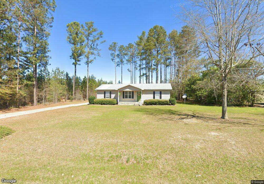
150 Old Swainsboro Rd Twin City, GA 30471
Estimated Value: $146,893 - $171,000
3
Beds
2
Baths
1,248
Sq Ft
$127/Sq Ft
Est. Value
About This Home
This home is located at 150 Old Swainsboro Rd, Twin City, GA 30471 and is currently estimated at $158,723, approximately $127 per square foot. 150 Old Swainsboro Rd is a home located in Emanuel County with nearby schools including Twin City Elementary School.
Ownership History
Date
Name
Owned For
Owner Type
Purchase Details
Closed on
Nov 2, 2021
Sold by
Miller Michael K
Bought by
Miller Meghin L
Current Estimated Value
Purchase Details
Closed on
Oct 28, 2016
Bought by
Miller Michael
Home Financials for this Owner
Home Financials are based on the most recent Mortgage that was taken out on this home.
Original Mortgage
$62,525
Interest Rate
3.42%
Mortgage Type
New Conventional
Purchase Details
Closed on
Jul 2, 2015
Sold by
Hodges Donna
Bought by
Jdk Rental Properties Llc
Purchase Details
Closed on
Jan 1, 2006
Bought by
Hodges Donna B
Create a Home Valuation Report for This Property
The Home Valuation Report is an in-depth analysis detailing your home's value as well as a comparison with similar homes in the area
Home Values in the Area
Average Home Value in this Area
Purchase History
| Date | Buyer | Sale Price | Title Company |
|---|---|---|---|
| Miller Meghin L | -- | -- | |
| Miller Meghin Lane | -- | -- | |
| Miller Michael | $61,900 | -- | |
| Jdk Rental Properties Llc | -- | -- | |
| Hodges Donna B | $68,200 | -- |
Source: Public Records
Mortgage History
| Date | Status | Borrower | Loan Amount |
|---|---|---|---|
| Previous Owner | Miller Michael | $62,525 |
Source: Public Records
Tax History Compared to Growth
Tax History
| Year | Tax Paid | Tax Assessment Tax Assessment Total Assessment is a certain percentage of the fair market value that is determined by local assessors to be the total taxable value of land and additions on the property. | Land | Improvement |
|---|---|---|---|---|
| 2024 | $1,335 | $38,914 | $1,682 | $37,232 |
| 2023 | $936 | $34,450 | $1,321 | $33,128 |
| 2022 | $828 | $30,709 | $1,321 | $29,388 |
| 2021 | $741 | $28,872 | $1,201 | $27,671 |
| 2020 | $743 | $27,513 | $1,257 | $26,256 |
| 2019 | $739 | $27,513 | $1,257 | $26,256 |
| 2018 | $754 | $27,513 | $1,257 | $26,256 |
| 2017 | $757 | $27,513 | $1,257 | $26,256 |
| 2016 | $773 | $28,099 | $1,257 | $26,842 |
| 2015 | -- | $28,099 | $1,257 | $26,842 |
| 2014 | -- | $27,403 | $1,257 | $26,146 |
| 2013 | -- | $27,044 | $1,134 | $25,910 |
Source: Public Records
Map
Nearby Homes
- 317 5th Ave
- 164 5th Ave
- 211 6th Ave
- 912 5th Ave
- 1120 5th Ave
- 0 Scarboro Church Rd Unit 25066343
- 889 Ga Highway 192 N
- 501 S Old Reidsville Rd
- S S Old Reidsville Rd
- 184 Eagle Pass
- 56 Rock Creek Rd
- 3770 Hill Rd
- 11 Plantation Dr
- 75 Scuffletown Rd
- 000 Scuffletown Rd
- 410 L B Hall Rd
- 875 Prosperity Dr
- 849 Prosperity Dr
- 843 Prosperity Dr
- 760 Memphis Rd
- 150 Swainsboro Rd
- 144 Old Swainsboro Rd
- 149 Old Swainsboro Rd
- 143 Old Swainsboro Rd
- 139 Old Swainsboro Rd
- 134 Lane Ave
- 134 Leonard Ave
- 204 Old Swainsboro Rd
- 139 Lane Ave
- 104 Central St
- 135 Lane Ave
- 124 Leonard Ave
- 130 Leonard Ave
- 0 Lane Ave Unit 3066981
- 118 Sergeant St
- 127 Lane Ave
- 214 Old Swainsboro Rd
- 0 Central St Unit 7375076
- 0 Central St Unit 7074358
- 0 Central St