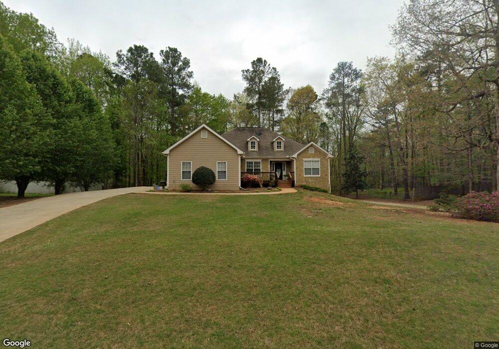
150 River Park Cir McDonough, GA 30252
Estimated Value: $327,201 - $358,000
3
Beds
3
Baths
2,053
Sq Ft
$169/Sq Ft
Est. Value
About This Home
This home is located at 150 River Park Cir, McDonough, GA 30252 and is currently estimated at $347,550, approximately $169 per square foot. 150 River Park Cir is a home located in Henry County with nearby schools including New Hope Elementary School, Ola Middle School, and New Creation Christian Academy.
Ownership History
Date
Name
Owned For
Owner Type
Purchase Details
Closed on
Mar 8, 2002
Sold by
Howe John G
Bought by
Diddle John J and Diddle Lori L
Current Estimated Value
Home Financials for this Owner
Home Financials are based on the most recent Mortgage that was taken out on this home.
Original Mortgage
$139,000
Outstanding Balance
$56,662
Interest Rate
6.86%
Mortgage Type
New Conventional
Estimated Equity
$290,888
Purchase Details
Closed on
Jul 28, 2000
Sold by
New Image Builders Inc
Bought by
Howe John G
Home Financials for this Owner
Home Financials are based on the most recent Mortgage that was taken out on this home.
Original Mortgage
$157,700
Interest Rate
8.23%
Mortgage Type
New Conventional
Create a Home Valuation Report for This Property
The Home Valuation Report is an in-depth analysis detailing your home's value as well as a comparison with similar homes in the area
Home Values in the Area
Average Home Value in this Area
Purchase History
| Date | Buyer | Sale Price | Title Company |
|---|---|---|---|
| Diddle John J | $164,500 | -- | |
| Howe John G | $166,000 | -- |
Source: Public Records
Mortgage History
| Date | Status | Borrower | Loan Amount |
|---|---|---|---|
| Open | Diddle John J | $139,000 | |
| Previous Owner | Howe John G | $157,700 |
Source: Public Records
Tax History Compared to Growth
Tax History
| Year | Tax Paid | Tax Assessment Tax Assessment Total Assessment is a certain percentage of the fair market value that is determined by local assessors to be the total taxable value of land and additions on the property. | Land | Improvement |
|---|---|---|---|---|
| 2025 | $4,599 | $164,480 | $18,000 | $146,480 |
| 2024 | $4,599 | $147,040 | $18,000 | $129,040 |
| 2023 | $3,541 | $135,720 | $14,000 | $121,720 |
| 2022 | $3,494 | $112,320 | $14,000 | $98,320 |
| 2021 | $2,979 | $90,560 | $14,000 | $76,560 |
| 2020 | $2,904 | $87,360 | $12,000 | $75,360 |
| 2019 | $2,814 | $83,560 | $12,000 | $71,560 |
| 2018 | $2,581 | $73,720 | $12,000 | $61,720 |
| 2016 | $2,307 | $66,160 | $10,000 | $56,160 |
| 2015 | $2,102 | $59,440 | $8,000 | $51,440 |
| 2014 | $1,913 | $54,160 | $8,000 | $46,160 |
Source: Public Records
Map
Nearby Homes
- 151 River Park Cir
- 845 Graeme Dr
- 812 Graeme Dr
- 767 Old Jackson Rd
- 225 Laney Ct
- 175 Laney Ct Unit 1
- 461 Old Jackson Rd
- 215 Laney Rd
- 125 Laney Ct
- 153 Hilda Way
- 136 Hilda Way
- 315 S Bethany Rd
- 995 Old Jackson Rd
- 275 S Bethany Rd
- 281 Laney Dr
- 125 Karen Dr
- 2563 Highway 81 E
- 242 Old Jackson Rd
- 121, 125, 129 Case Dr
- 705 S Bethany Rd
- 152 River Park Cir
- 148 River Park Cir
- 154 River Park Cir
- 125 Creekside Way
- 146 River Park Cir
- 149 River Park Cir
- 147 River Park Cir
- 115 Creekside Way
- 157 River Park Cir
- 145 River Park Cir
- 144 River Park Cir
- 105 Creekside Way
- 135 Creekside Way
- 158 River Park Cir
- 0 Chestatee Trace Unit 8624823
- 0 Chestatee Trace Unit 8524063
- 0 Chestatee Trace Unit 8873344
- 0 Chestatee Trace Unit 3173154
- 0 Chestatee Trace Unit 7595756
- 307 Oconee Ct