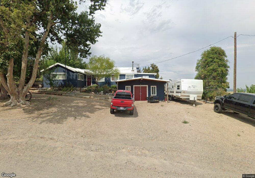
1500 Hill Rd Homedale, ID 83628
Estimated Value: $372,000 - $544,000
--
Bed
1
Bath
2,116
Sq Ft
$201/Sq Ft
Est. Value
About This Home
This home is located at 1500 Hill Rd, Homedale, ID 83628 and is currently estimated at $426,221, approximately $201 per square foot. 1500 Hill Rd is a home with nearby schools including Homedale Elementary School, Homedale Middle School, and Homedale High School.
Ownership History
Date
Name
Owned For
Owner Type
Purchase Details
Closed on
Jun 27, 2006
Sold by
Aberasturi Daniel P and Aberasturi Wendy R
Bought by
Taylor David A and Taylor Charmaine D
Current Estimated Value
Home Financials for this Owner
Home Financials are based on the most recent Mortgage that was taken out on this home.
Original Mortgage
$128,000
Outstanding Balance
$75,654
Interest Rate
6.57%
Mortgage Type
New Conventional
Estimated Equity
$350,567
Create a Home Valuation Report for This Property
The Home Valuation Report is an in-depth analysis detailing your home's value as well as a comparison with similar homes in the area
Home Values in the Area
Average Home Value in this Area
Purchase History
| Date | Buyer | Sale Price | Title Company |
|---|---|---|---|
| Taylor David A | -- | -- |
Source: Public Records
Mortgage History
| Date | Status | Borrower | Loan Amount |
|---|---|---|---|
| Open | Taylor David A | $128,000 |
Source: Public Records
Tax History Compared to Growth
Tax History
| Year | Tax Paid | Tax Assessment Tax Assessment Total Assessment is a certain percentage of the fair market value that is determined by local assessors to be the total taxable value of land and additions on the property. | Land | Improvement |
|---|---|---|---|---|
| 2024 | -- | $309,699 | $47,079 | $262,620 |
| 2023 | $1,064 | $309,699 | $47,079 | $262,620 |
| 2022 | $1,099 | $282,189 | $47,079 | $235,110 |
| 2021 | $790 | $182,469 | $34,599 | $147,870 |
| 2020 | $571 | $129,650 | $16,046 | $113,604 |
| 2019 | $601 | $114,734 | $16,046 | $98,688 |
| 2018 | $648 | $118,804 | $13,372 | $105,432 |
| 2017 | $558 | $109,180 | $13,372 | $95,808 |
| 2016 | $418 | $76,170 | $12,858 | $63,312 |
| 2014 | $417 | $56,921 | $12,128 | $44,793 |
| 2011 | -- | $71,096 | $11,000 | $60,096 |
Source: Public Records
Map
Nearby Homes
- 1006 Hill Rd
- TBD River Rd
- 1212 River Rd
- 1964 River Rd
- 00 Peckham Rd
- 28323 Silo Way
- 00 Lower Pleasant Ridge Rd
- 20383 Riverpoint Ln
- 0 Riverpoint Ln
- 21488 Case Ln
- 0 Tbd Unit 25095901
- 0 Tbd Unit 23668088
- 0 Tbd Unit 11500486
- TBD
- 27607 Petolla Rd
- 1547 Highway 201
- 0 Tbd Peckham Rd
- Rd
- 28282 Fox Ln
- 501 W California Ave