Estimated Value: $162,000 - $182,000
3
Beds
2
Baths
1,126
Sq Ft
$152/Sq Ft
Est. Value
About This Home
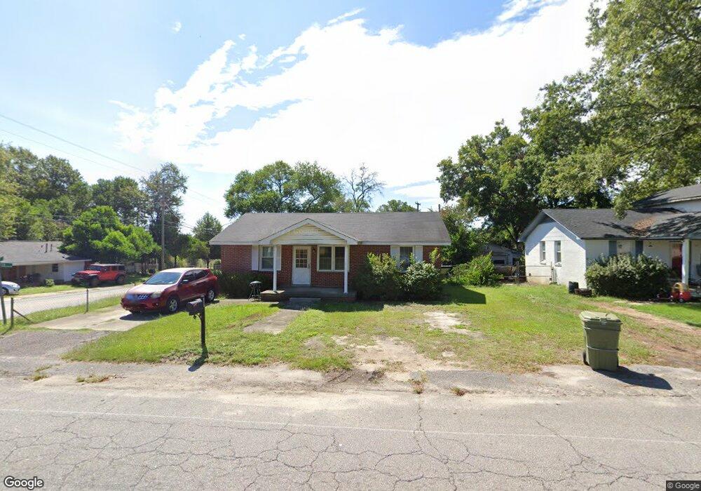
This home is located at 1501 Dunbar Rd, Cayce, SC 29033 and is currently estimated at $171,354, approximately $152 per square foot. 1501 Dunbar Rd is a home located in Lexington County with nearby schools including Cayce Elementary, Cyril B. Busbee Creative Arts Academy, and Brookland-Cayce High School.
Ownership History
Date
Name
Owned For
Owner Type
Purchase Details
Closed on
Feb 5, 2020
Sold by
Gabe Michael John
Bought by
Pierson William Clay
Current Estimated Value
Home Financials for this Owner
Home Financials are based on the most recent Mortgage that was taken out on this home.
Original Mortgage
$70,000
Outstanding Balance
$62,144
Interest Rate
3.74%
Mortgage Type
New Conventional
Estimated Equity
$109,210
Purchase Details
Closed on
May 18, 2017
Sold by
Gunter James Guy
Bought by
Gabe Michael and Gabe Michael John
Purchase Details
Closed on
Jan 26, 2016
Sold by
Woodruff Jeannie R
Bought by
Gunter James Guy and Woodruff Jeannie R
Create a Home Valuation Report for This Property
The Home Valuation Report is an in-depth analysis detailing your home's value as well as a comparison with similar homes in the area
Home Values in the Area
Average Home Value in this Area
Purchase History
| Date | Buyer | Sale Price | Title Company |
|---|---|---|---|
| Pierson William Clay | -- | None Available | |
| Pierson William Clay | -- | None Available | |
| Gabe Michael | $80,000 | None Available | |
| Gunter James Guy | -- | None Available |
Source: Public Records
Mortgage History
| Date | Status | Borrower | Loan Amount |
|---|---|---|---|
| Open | Pierson William Clay | $70,000 |
Source: Public Records
Tax History Compared to Growth
Tax History
| Year | Tax Paid | Tax Assessment Tax Assessment Total Assessment is a certain percentage of the fair market value that is determined by local assessors to be the total taxable value of land and additions on the property. | Land | Improvement |
|---|---|---|---|---|
| 2024 | $1,801 | $4,303 | $1,200 | $3,103 |
| 2023 | $1,651 | $4,303 | $1,200 | $3,103 |
| 2022 | $1,544 | $4,303 | $1,200 | $3,103 |
| 2020 | $1,474 | $4,303 | $1,200 | $3,103 |
| 2019 | $1,663 | $4,800 | $1,200 | $3,600 |
| 2018 | $1,629 | $4,800 | $1,200 | $3,600 |
| 2017 | $1,194 | $3,566 | $1,200 | $2,366 |
| 2016 | $410 | $2,377 | $800 | $1,577 |
| 2014 | $1,181 | $4,084 | $1,200 | $2,884 |
| 2013 | -- | $4,080 | $1,200 | $2,880 |
Source: Public Records
Map
Nearby Homes
- Dunbar II Plan at Dunbar Village
- 1519 Benedict St
- 1515 Benedict St
- 105 Odell Dr
- 109 Odell Dr
- 113 Odell Dr
- 1414 Hazel St
- 117 Odell Dr
- 121 Odell Dr
- 1409 Hazel St
- 125 Odell Dr
- 133 Odell Dr
- 129 Odell Dr
- 141 Odell Dr
- 000 Frink St
- 2335 Laurie St
- 2337 Laurie St
- 2342 Laurie St
- 2326 Baxter St
- TBD Poplar Lots A B & C St
- 1505 Dunbar Rd
- 1425 Dunbar Rd
- 1509 Dunbar Rd
- 1500 Abbott Rd
- 1502 Abbott Rd
- 1421 Dunbar Rd
- 1513 Dunbar Rd
- 1508 Abbott Rd
- 2101 Wilkinson St
- 1512 Abbott Rd
- 1423 Dunbar Rd
- 1519 Dunbar Rd
- 1518 Abbott Rd
- 1419 Dunbar Rd
- 1523 Dunbar Rd
- 1516 Abbott Rd
- 1508 Dunbar Rd
- 1424 Dunbar Rd
- 1501 Abbott Rd
- 1505 Abbott Rd