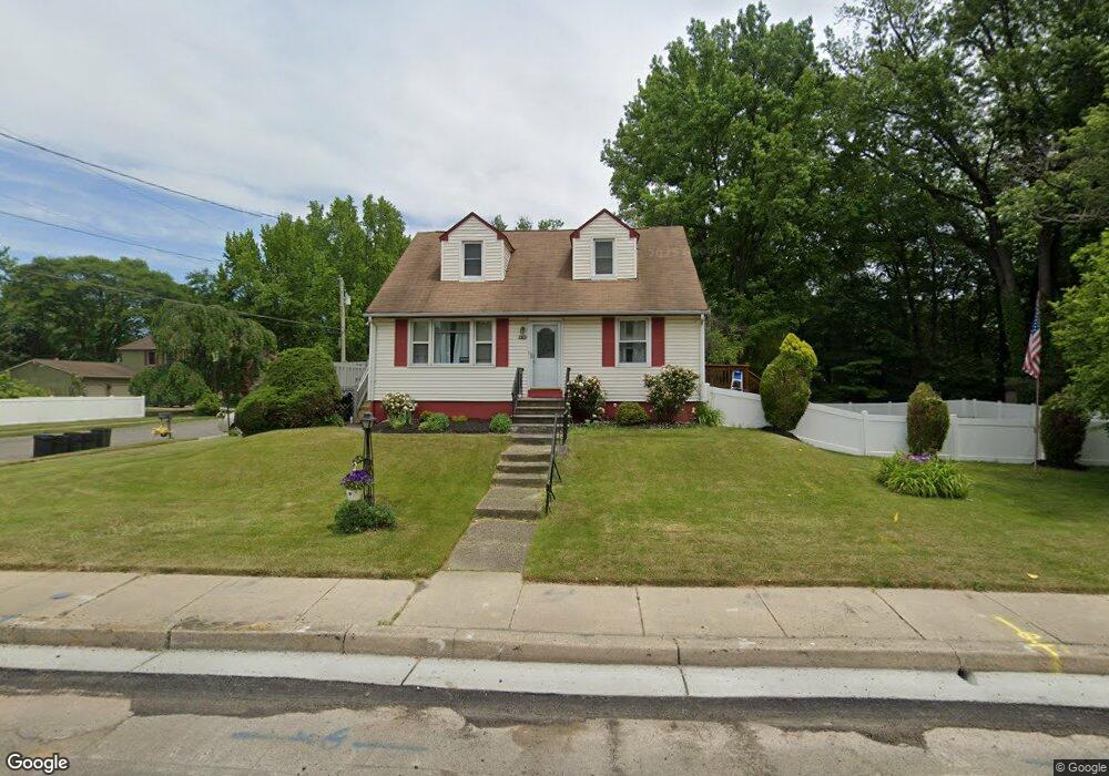
1501 S Burnt Mill Rd Voorhees, NJ 08043
Estimated Value: $272,427 - $398,000
--
Bed
--
Bath
1,434
Sq Ft
$247/Sq Ft
Est. Value
About This Home
This home is located at 1501 S Burnt Mill Rd, Voorhees, NJ 08043 and is currently estimated at $354,357, approximately $247 per square foot. 1501 S Burnt Mill Rd is a home located in Camden County with nearby schools including Osage Elementary School, Voorhees Middle School, and Eastern Regional High School.
Ownership History
Date
Name
Owned For
Owner Type
Purchase Details
Closed on
Sep 22, 1972
Bought by
German Peter
Current Estimated Value
Create a Home Valuation Report for This Property
The Home Valuation Report is an in-depth analysis detailing your home's value as well as a comparison with similar homes in the area
Home Values in the Area
Average Home Value in this Area
Purchase History
| Date | Buyer | Sale Price | Title Company |
|---|---|---|---|
| German Peter | $23,000 | -- |
Source: Public Records
Tax History Compared to Growth
Tax History
| Year | Tax Paid | Tax Assessment Tax Assessment Total Assessment is a certain percentage of the fair market value that is determined by local assessors to be the total taxable value of land and additions on the property. | Land | Improvement |
|---|---|---|---|---|
| 2025 | $6,261 | $262,900 | $69,800 | $193,100 |
| 2024 | $6,149 | $145,600 | $70,500 | $75,100 |
| 2023 | $6,149 | $145,600 | $70,500 | $75,100 |
| 2022 | $6,025 | $145,600 | $70,500 | $75,100 |
| 2021 | $5,987 | $145,600 | $70,500 | $75,100 |
| 2020 | $5,955 | $145,600 | $70,500 | $75,100 |
| 2019 | $5,745 | $145,600 | $70,500 | $75,100 |
| 2018 | $5,708 | $145,600 | $70,500 | $75,100 |
| 2017 | $5,610 | $145,600 | $70,500 | $75,100 |
| 2016 | $5,352 | $145,600 | $70,500 | $75,100 |
| 2015 | $5,457 | $145,600 | $70,500 | $75,100 |
| 2014 | $5,389 | $145,600 | $70,500 | $75,100 |
Source: Public Records
Map
Nearby Homes
- 37 Dunhill Dr
- 1800 S Burnt Mill Rd
- 1309 Locust Ave
- 1135 Gibbsboro Rd
- 3401 Jennifer Ct
- 113 Harvard Ave
- 5102 Tracy Ct
- 804 S Burnt Mill Rd
- 18 Yale Ave
- 1193 Kirkwood-Gibbsboro R
- 6 Turnberry Ct
- 1100 Rural Ave
- 116 Van Buren Rd Unit 8
- 1256 Kirkwood-Gibbsboro R
- 8 Pennsylvania Ave
- 401 S Browning Ave
- 7 Sidney Ln
- 7 Wright Ave
- 121 Union Ave
- 126 1 Kirkbride Rd
- 1500 S Burnt Mill Rd
- 1308 Poplar Ave
- 1505 S Burnt Mill Rd
- 1405 S Burnt Mill Rd
- 1309 Linden Ave
- 1201 Linden Ave
- 1204 Poplar Ave
- 1201 Poplar Ave
- 1313 Linden Ave
- 1312 Poplar Ave
- 1208 Poplar Ave
- 1400 S Burnt Mill Rd
- 1401 S Burnt Mill Rd
- 1601 S Burnt Mill Rd
- 1315 Poplar Ave
- 1205 Poplar Ave
- 1304 Maple Ave
- 1317 Linden Ave
- 1308 Linden Ave
- 1600 S Burnt Mill Rd