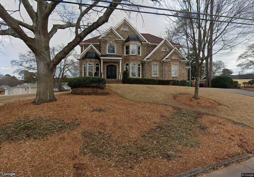
1503 Springbrook Dr Decatur, GA 30033
Estimated Value: $904,827 - $1,480,000
6
Beds
6
Baths
560
Sq Ft
$1,981/Sq Ft
Est. Value
About This Home
This home is located at 1503 Springbrook Dr, Decatur, GA 30033 and is currently estimated at $1,109,457, approximately $1,981 per square foot. 1503 Springbrook Dr is a home located in DeKalb County with nearby schools including Briarlake Elementary School, Henderson Middle School, and Lakeside High School.
Ownership History
Date
Name
Owned For
Owner Type
Purchase Details
Closed on
Mar 9, 2007
Sold by
Precision Dev Inc
Bought by
Mason Racquel H
Current Estimated Value
Home Financials for this Owner
Home Financials are based on the most recent Mortgage that was taken out on this home.
Original Mortgage
$672,086
Outstanding Balance
$399,552
Interest Rate
6.3%
Mortgage Type
New Conventional
Estimated Equity
$709,905
Purchase Details
Closed on
Aug 18, 2006
Sold by
Secured Group Investors Inc & +
Bought by
Precision Dev Inc
Purchase Details
Closed on
Feb 23, 2006
Sold by
Secured Group Investors Inc
Bought by
Secured Group Investors Inc
Purchase Details
Closed on
Nov 26, 1997
Sold by
Melton Charlotte C and Cofer Shirley B
Bought by
Lowenhaupt Carol
Home Financials for this Owner
Home Financials are based on the most recent Mortgage that was taken out on this home.
Original Mortgage
$65,550
Interest Rate
7.38%
Mortgage Type
New Conventional
Create a Home Valuation Report for This Property
The Home Valuation Report is an in-depth analysis detailing your home's value as well as a comparison with similar homes in the area
Purchase History
| Date | Buyer | Sale Price | Title Company |
|---|---|---|---|
| Mason Racquel H | $840,200 | -- | |
| Precision Dev Inc | $200,000 | -- | |
| Secured Group Investors Inc | -- | -- | |
| Secured Group Investors Inc | $167,000 | -- | |
| Lowenhaupt Carol | $71,900 | -- |
Source: Public Records
Mortgage History
| Date | Status | Borrower | Loan Amount |
|---|---|---|---|
| Open | Mason Racquel H | $672,086 | |
| Previous Owner | Lowenhaupt Carol | $65,550 |
Source: Public Records
Tax History
| Year | Tax Paid | Tax Assessment Tax Assessment Total Assessment is a certain percentage of the fair market value that is determined by local assessors to be the total taxable value of land and additions on the property. | Land | Improvement |
|---|---|---|---|---|
| 2025 | $10,817 | $349,280 | $52,680 | $296,600 |
| 2024 | $11,313 | $349,160 | $52,680 | $296,480 |
| 2023 | $11,313 | $332,960 | $52,680 | $280,280 |
Source: Public Records
Map
Nearby Homes
- 2983 Frazier Ct
- 1463 Crescent Walk
- 1507 Frazier Rd
- 1597 Frazier Rd
- 2951 Haralson Rd
- 1542 Riderwood Ct
- 2927 Ponderosa Cir
- 1362 Faraday Place Unit 4
- 2771 Pangborn Rd
- 3031 Wilson Rd
- 3084 Turman Cir
- 1402 Mclendon Dr
- 1300 Hopkins Dr
- 2986 Wilson Cir
- 3009 Eltham Place
- 2427 Lawrenceville Hwy Unit 4
- 2981 Wilsons Crossing Ct
- 2425 Lawrenceville Hwy Unit 7
- 2425 Lawrenceville Hwy
- 1792 Frazier Rd
- 2988 Pangborn Rd
- 2974 Pangborn Rd
- 2980 Pangborn Rd
- 1512 Springbrook Dr
- 1519 Springbrook Dr
- 2987 Frazier Ct
- 2966 Pangborn Rd
- 2996 Pangborn Rd
- 1502 Springbrook Dr
- 2993 Frazier Ct
- 1525 Springbrook Dr
- 2958 Pangborn Rd
- 2997 Frazier Ct
- 1527 Springbrook Dr
- 2961 Sandra Ln
- 3003 Frazier Ct
- 1476 Crescent Walk
- 2984 Frazier Ct
- 1526 Springbrook Dr
- 2973 Pangborn Rd
Your Personal Tour Guide
Ask me questions while you tour the home.