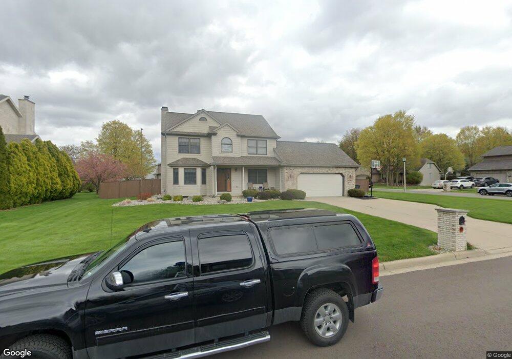
1504 Smokedrift Ln Lansing, MI 48917
Estimated Value: $325,647 - $370,000
3
Beds
3
Baths
1,722
Sq Ft
$196/Sq Ft
Est. Value
About This Home
This home is located at 1504 Smokedrift Ln, Lansing, MI 48917 and is currently estimated at $337,412, approximately $195 per square foot. 1504 Smokedrift Ln is a home located in Eaton County with nearby schools including Willow Ridge Elementary School, Leon W. Hayes Middle School, and Grand Ledge High School.
Ownership History
Date
Name
Owned For
Owner Type
Purchase Details
Closed on
Oct 7, 2022
Sold by
Vedder Erich G and Vedder Tiffany C
Bought by
Erich And Tiffany Vedder Trust and Vedder
Current Estimated Value
Purchase Details
Closed on
Jul 26, 2022
Sold by
Erich G Vedder Trust
Bought by
Erich And Tiffany Vedder Family Trust
Purchase Details
Closed on
Mar 18, 2015
Sold by
Vedder Erich G and Vedder Tiffany C
Bought by
Erich G Vedder Trust and Tiffany C Vedder Trust
Create a Home Valuation Report for This Property
The Home Valuation Report is an in-depth analysis detailing your home's value as well as a comparison with similar homes in the area
Home Values in the Area
Average Home Value in this Area
Purchase History
| Date | Buyer | Sale Price | Title Company |
|---|---|---|---|
| Erich And Tiffany Vedder Trust | -- | None Listed On Document | |
| Erich And Tiffany Vedder Family Trust | -- | -- | |
| Erich G Vedder Trust | -- | None Available |
Source: Public Records
Tax History Compared to Growth
Tax History
| Year | Tax Paid | Tax Assessment Tax Assessment Total Assessment is a certain percentage of the fair market value that is determined by local assessors to be the total taxable value of land and additions on the property. | Land | Improvement |
|---|---|---|---|---|
| 2025 | $4,373 | $138,300 | $0 | $0 |
| 2024 | $2,114 | $130,500 | $0 | $0 |
| 2023 | $1,970 | $121,800 | $0 | $0 |
| 2022 | $3,749 | $113,300 | $0 | $0 |
| 2021 | $3,589 | $109,700 | $0 | $0 |
| 2020 | $3,521 | $100,900 | $0 | $0 |
| 2019 | $3,460 | $98,303 | $0 | $0 |
| 2018 | $3,253 | $97,200 | $0 | $0 |
| 2017 | $3,186 | $92,000 | $0 | $0 |
| 2016 | -- | $88,600 | $0 | $0 |
| 2015 | -- | $84,300 | $0 | $0 |
| 2014 | -- | $80,700 | $0 | $0 |
| 2013 | -- | $79,600 | $0 | $0 |
Source: Public Records
Map
Nearby Homes
- 5910 Cabrena Dr
- 6512 Spring Tree Ln Unit 14
- 6333 Larocque Cir
- 6542 Brook Trail
- 6361 Larocque Cir
- 6606 Windsong Way
- 6725 French Creek Dr
- 1516 Elmwood Rd
- 5754 River Ridge Dr
- 1108 Summergreen Ln Unit 103
- 2212 Holiday Ln
- 1527 Lindy Dr
- 1120 Rolling Green Ln
- 5201 Greenbriar Rd
- 1031 Mall Dr E
- 4915 Canyon Trail
- 1205 Woodmeadow Unit 201
- 1049 Maycroft Rd
- 4806 W Willow Hwy
- 1106 S Ridge Rd
- 1514 Smokedrift Ln
- 6000 Stoney Point Dr
- 6015 Stoney Point Dr
- 1522 Smokedrift Ln
- 1505 Smokedrift Ln
- 5930 Stoney Point Dr
- 6003 Stoney Point Dr
- 1515 Smokedrift Ln
- 5935 Stoney Point Dr
- 1415 Smokedrift Ln
- 5922 Stoney Point Dr
- 1521 Smokedrift Ln
- 1530 Smokedrift Ln
- 5925 Sunchase Cir
- 5925 Stoney Point Dr
- 6034 Stoney Point Dr
- 5931 Sunchase Cir
- 5904 Cabrena Dr
- 1409 Smokedrift Ln
- 1514 Alan Ln