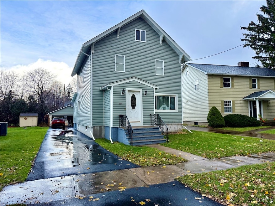


1505 Brookside Ave Utica, NY 13501
East Utica NeighborhoodEstimated payment $1,542/month
Highlights
- Deck
- Eat-In Kitchen
- Forced Air Heating System
- Wood Flooring
- Laundry Room
- 4-minute walk to O'Connor Park
About This Home
THIS HOME DEFINETELY CHECKS ALL THE BOXES AND SOME!! All Major updates within a 5- year period including a roof, Vinyl siding, windows, electric, hot water tank, driveway and the list goes on! This 3 Bdrm 1.5 Bath home boasts gleaming hardwoods throughout, generously sized Bdrms, formal living and dining room, bright and open kitchen fully equipped with stainless appliances. Rear family room leading out to a deck, large, partially fenced yard, 2 stall garage in a very idyllic location!
Listing Agent
Listing by Coldwell Banker Faith Properties License #40BR1114558 Listed on: 11/13/2025

Home Details
Home Type
- Single Family
Est. Annual Taxes
- $4,777
Year Built
- Built in 1925
Lot Details
- 7,938 Sq Ft Lot
- Lot Dimensions are 49x162
- Partially Fenced Property
- Rectangular Lot
- Historic Home
Parking
- 2 Car Garage
- Carport
- Driveway
Home Design
- Block Foundation
- Vinyl Siding
Interior Spaces
- 1,728 Sq Ft Home
- 2-Story Property
- Laundry Room
Kitchen
- Eat-In Kitchen
- Gas Oven
- Gas Range
- Microwave
- Dishwasher
Flooring
- Wood
- Laminate
- Ceramic Tile
Bedrooms and Bathrooms
- 3 Bedrooms
Basement
- Basement Fills Entire Space Under The House
- Laundry in Basement
Outdoor Features
- Deck
Schools
- Thomas R Proctor High School
Utilities
- Forced Air Heating System
- Heating System Uses Gas
- Gas Water Heater
Community Details
- Brookside Park Subdivision
Listing and Financial Details
- Tax Lot 33
- Assessor Parcel Number 301600-330-008-0003-033-000-0000
Map
Home Values in the Area
Average Home Value in this Area
Tax History
| Year | Tax Paid | Tax Assessment Tax Assessment Total Assessment is a certain percentage of the fair market value that is determined by local assessors to be the total taxable value of land and additions on the property. | Land | Improvement |
|---|---|---|---|---|
| 2024 | $2,628 | $65,000 | $12,500 | $52,500 |
| 2023 | $1,743 | $65,000 | $12,500 | $52,500 |
| 2022 | $2,637 | $65,000 | $12,500 | $52,500 |
| 2021 | $2,622 | $65,000 | $12,500 | $52,500 |
| 2020 | $2,571 | $65,000 | $12,500 | $52,500 |
| 2019 | $781 | $65,000 | $12,500 | $52,500 |
| 2018 | $2,580 | $65,000 | $12,500 | $52,500 |
| 2017 | $2,523 | $65,000 | $12,500 | $52,500 |
| 2016 | $3,454 | $65,000 | $12,500 | $52,500 |
| 2015 | -- | $65,000 | $12,500 | $52,500 |
| 2014 | -- | $65,000 | $12,500 | $52,500 |
Property History
| Date | Event | Price | List to Sale | Price per Sq Ft |
|---|---|---|---|---|
| 01/12/2026 01/12/26 | Pending | -- | -- | -- |
| 11/13/2025 11/13/25 | For Sale | $219,900 | -- | $127 / Sq Ft |
Purchase History
| Date | Type | Sale Price | Title Company |
|---|---|---|---|
| Deed | $39,000 | -- | |
| Deed | $88,000 | -- | |
| Deed | $59,900 | -- | |
| Deed | $11,666 | -- | |
| Deed | $23,334 | -- |
Source: Mid New York Regional MLS
MLS Number: S1650854
APN: 330-008-0003-033-000-0000
Disclaimer: Certain information contained herein is derived from information provided by parties other than Homes.com. All information provided is deemed reliable, but is not guaranteed to be accurate and should be independently verified.
![]() IDX information is provided exclusively for personal, non-commercial use, and may not be used for any purpose other than to identify prospective properties consumers may be interested in purchasing. Information is deemed reliable but not guaranteed.
IDX information is provided exclusively for personal, non-commercial use, and may not be used for any purpose other than to identify prospective properties consumers may be interested in purchasing. Information is deemed reliable but not guaranteed.
- 1603 Harrison Ave
- 653 Parkway E
- 902 James St
- 722 Eleanor Place Unit 724
- 1504 Conkling Ave
- 1235 Hammond Ave Unit 2
- 8 Waterford Ln
- 1534 Brinckerhoff Ave
- 1569 & 1565 Dudley Ave
- 733 Eagle St
- 914 Eagle St
- 1610 Dudley Ave
- 1573 Seymour Ave
- 1577 Seymour Ave
- 1242 Hilton Ave
- 1227 Hillview Dr
- 504 Eagle St
- 1624 Seymour Ave
- 1302 Seymour Ave
- 324-326 Jmaes St
Ask me questions while you tour the home.